An official website of the United States government
Here's how you know
Official websites use .gov
A .gov website belongs to an official government organization in the United States.
Secure .gov websites use HTTPS
A lock () or https:// means you’ve safely connected to the .gov website. Share sensitive information only on official, secure websites.
The Colorado Water Science Center Network Integration and Science Innovation team has focused on installing cameras at U.S. Geological Survey (USGS) monitoring locations for situational and observational awareness of conditions at streams, rivers, and lakes in Colorado. Several USGS monitoring locations have been configured with cellular modems and network cameras to obtain still and video imagery of real-time flow conditions and telemeter those images in real time to where they are available online. Imagery obtained at the monitoring locations are served through the web applications USGS Hydrologic Imagery and Visualization Information System (HIVIS) and the USGS National Water Dashboard to the public.
The number of camera installations at USGS monitoring locations have been increasing substantially during the past several years. USGS currently operates more than 850 cameras nationwide, with 1 to 5 new cameras installed every week. The imagery obtained from these installations is used for a wide variety of applications. Nationally, the main purpose of imagery is to provide situational or observational awareness. Other uses include image velocimetry for river discharge computation, ice or algae detection, and water level estimation.
Figure 1- Map of camera locations at USGS monitoring sites as of March 2025.
The Colorado Water Science Center has operated a small network of cameras for several years at monitoring locations across the state. USGS staff use these cameras, among other things, to document hydrologic conditions, identify changes in channel conditions, and provide general observations of river, lake, or stream conditions in real-time. Moreover, real-time imagery can be used to improve efficiency by prioritizing field efforts, such as discharge measurements and water-quality sampling, based on observed river conditions; thereby saving time by optimizing field trips to changing conditions. In addition, stored imagery can improve hydrologic data analysis by providing visual documentation of unusual environmental conditions, which may affect remotely collected data. The camera imagery also is used by cooperators and the public to observe river conditions in real-time; identify natural hazards such as ice, debris, or high turbidity events; or make business or recreational decisions based on real-time conditions.
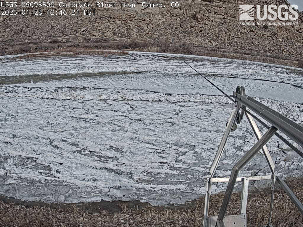
Figure 2- Camera view illustrating ice cover conditions. Camera image and additional information are available on the HIVIS website.
Camera installations typically consist of a network camera, a cellular modem or gateway, and a variety of power and networking hardware. The hardware can be installed to operate stand-alone, that is with no other hardware interfaced with the camera system, or can be installed to interface with datalogging equipment typically used at streamflow monitoring locations. The stand-alone configuration is simpler to install but requires additional power capacity (batteries and solar panels) because the equipment is continuously powered. In contrast, a camera system, which is integrated with data logging equipment, can have smaller batteries and needs less solar energy because the power cycle can be controlled by the data logger using scripts.
Imagery at locations used for situational or observational awareness are typically collected at 15-minute intervals during daylight hours. The imagery then can be aligned with time-series data collected at the location, for example, streamflow. The images are served through the web applications USGS HIVIS and USGS National Water Dashboard for USGS, cooperator, and public use. Imagery can be an efficient, valuable, and reliable source of information for USGS staff, cooperators, businesses, and the public.
The Next Generation Water Observing System (NGWOS) supports water availability assessments, management, and prediction by enhancing water observations in basins that represent major U.S. hydrologic regions. NGWOS provides high-resolution, real-time data on water quantity, quality, and use, as well as advance the development and application of new sensor technologies and remote sensing methods.
The Next Generation Water Observing System (NGWOS) supports water availability assessments, management, and prediction by enhancing water observations in basins that represent major U.S. hydrologic regions. NGWOS provides high-resolution, real-time data on water quantity, quality, and use, as well as advance the development and application of new sensor technologies and remote sensing methods.
The Next Generation Water Observing System (NGWOS) provides high-fidelity, real-time data on water quantity, quality, and use to support modern prediction and decision-support systems that are necessary for informing water operations on a daily basis and decision-making during water emergencies. The headwaters of the Colorado and Gunnison River Basins provide an opportunity to implement NGWOS in a...
Next Generation Water Observing System: Upper Colorado River Basin
The Next Generation Water Observing System (NGWOS) provides high-fidelity, real-time data on water quantity, quality, and use to support modern prediction and decision-support systems that are necessary for informing water operations on a daily basis and decision-making during water emergencies. The headwaters of the Colorado and Gunnison River Basins provide an opportunity to implement NGWOS in a...
Colorado River above Roaring Fork River at Glenwood Springs, Colorado
Contrasting conditions on the Colorado and Roaring Fork Rivers at streamgage 393259107194801, Colorado River above Roaring Fork River at Glenwood Springs, CO.
Contrasting conditions on the Colorado and Roaring Fork Rivers at streamgage 393259107194801, Colorado River above Roaring Fork River at Glenwood Springs, CO.
The National Imagery Management System (NIMS) is a comprehensive infrastructure designed to collect, store, process, and deliver imagery collected by cameras managed by the U.S. Geological Survey (USGS) for public and scientific use. NIMS supports a wide range of hydrologic and environmental monitoring applications.
Many USGS water-resource monitoring sites have webcams installed to allow remote visibility of current water and environmental conditions, identify technical issues, verify remote measurements, and gather data for visual analyses. The Hydrologic Imagery Visualization and Information System (HIVIS) provides access to still-frame images and timelapse videos from our active webcams.
The Colorado Water Science Center Network Integration and Science Innovation team has focused on installing cameras at U.S. Geological Survey (USGS) monitoring locations for situational and observational awareness of conditions at streams, rivers, and lakes in Colorado. Several USGS monitoring locations have been configured with cellular modems and network cameras to obtain still and video imagery of real-time flow conditions and telemeter those images in real time to where they are available online. Imagery obtained at the monitoring locations are served through the web applications USGS Hydrologic Imagery and Visualization Information System (HIVIS) and the USGS National Water Dashboard to the public.
The number of camera installations at USGS monitoring locations have been increasing substantially during the past several years. USGS currently operates more than 850 cameras nationwide, with 1 to 5 new cameras installed every week. The imagery obtained from these installations is used for a wide variety of applications. Nationally, the main purpose of imagery is to provide situational or observational awareness. Other uses include image velocimetry for river discharge computation, ice or algae detection, and water level estimation.
Figure 1- Map of camera locations at USGS monitoring sites as of March 2025.
The Colorado Water Science Center has operated a small network of cameras for several years at monitoring locations across the state. USGS staff use these cameras, among other things, to document hydrologic conditions, identify changes in channel conditions, and provide general observations of river, lake, or stream conditions in real-time. Moreover, real-time imagery can be used to improve efficiency by prioritizing field efforts, such as discharge measurements and water-quality sampling, based on observed river conditions; thereby saving time by optimizing field trips to changing conditions. In addition, stored imagery can improve hydrologic data analysis by providing visual documentation of unusual environmental conditions, which may affect remotely collected data. The camera imagery also is used by cooperators and the public to observe river conditions in real-time; identify natural hazards such as ice, debris, or high turbidity events; or make business or recreational decisions based on real-time conditions.
Figure 2- Camera view illustrating ice cover conditions. Camera image and additional information are available on the HIVIS website.
Camera installations typically consist of a network camera, a cellular modem or gateway, and a variety of power and networking hardware. The hardware can be installed to operate stand-alone, that is with no other hardware interfaced with the camera system, or can be installed to interface with datalogging equipment typically used at streamflow monitoring locations. The stand-alone configuration is simpler to install but requires additional power capacity (batteries and solar panels) because the equipment is continuously powered. In contrast, a camera system, which is integrated with data logging equipment, can have smaller batteries and needs less solar energy because the power cycle can be controlled by the data logger using scripts.
Imagery at locations used for situational or observational awareness are typically collected at 15-minute intervals during daylight hours. The imagery then can be aligned with time-series data collected at the location, for example, streamflow. The images are served through the web applications USGS HIVIS and USGS National Water Dashboard for USGS, cooperator, and public use. Imagery can be an efficient, valuable, and reliable source of information for USGS staff, cooperators, businesses, and the public.
The Next Generation Water Observing System (NGWOS) supports water availability assessments, management, and prediction by enhancing water observations in basins that represent major U.S. hydrologic regions. NGWOS provides high-resolution, real-time data on water quantity, quality, and use, as well as advance the development and application of new sensor technologies and remote sensing methods.
The Next Generation Water Observing System (NGWOS) supports water availability assessments, management, and prediction by enhancing water observations in basins that represent major U.S. hydrologic regions. NGWOS provides high-resolution, real-time data on water quantity, quality, and use, as well as advance the development and application of new sensor technologies and remote sensing methods.
The Next Generation Water Observing System (NGWOS) provides high-fidelity, real-time data on water quantity, quality, and use to support modern prediction and decision-support systems that are necessary for informing water operations on a daily basis and decision-making during water emergencies. The headwaters of the Colorado and Gunnison River Basins provide an opportunity to implement NGWOS in a...
Next Generation Water Observing System: Upper Colorado River Basin
The Next Generation Water Observing System (NGWOS) provides high-fidelity, real-time data on water quantity, quality, and use to support modern prediction and decision-support systems that are necessary for informing water operations on a daily basis and decision-making during water emergencies. The headwaters of the Colorado and Gunnison River Basins provide an opportunity to implement NGWOS in a...
Colorado River above Roaring Fork River at Glenwood Springs, Colorado
Contrasting conditions on the Colorado and Roaring Fork Rivers at streamgage 393259107194801, Colorado River above Roaring Fork River at Glenwood Springs, CO.
Contrasting conditions on the Colorado and Roaring Fork Rivers at streamgage 393259107194801, Colorado River above Roaring Fork River at Glenwood Springs, CO.
Colorado River above Roaring Fork River at Glenwood Springs, Colorado
Contrasting conditions on the Colorado and Roaring Fork Rivers at streamgage 393259107194801, Colorado River above Roaring Fork River at Glenwood Springs, CO.
Contrasting conditions on the Colorado and Roaring Fork Rivers at streamgage 393259107194801, Colorado River above Roaring Fork River at Glenwood Springs, CO.
The National Imagery Management System (NIMS) is a comprehensive infrastructure designed to collect, store, process, and deliver imagery collected by cameras managed by the U.S. Geological Survey (USGS) for public and scientific use. NIMS supports a wide range of hydrologic and environmental monitoring applications.
Many USGS water-resource monitoring sites have webcams installed to allow remote visibility of current water and environmental conditions, identify technical issues, verify remote measurements, and gather data for visual analyses. The Hydrologic Imagery Visualization and Information System (HIVIS) provides access to still-frame images and timelapse videos from our active webcams.