
USGS fishery biologist (GLSC; Ashland, Wisconsin) suturing a round whitefish (Prosopium cylindraceum) from Lake Superior as part of an acoustic telemetry project, a type of advanced technology. By tagging the specimen with an acoustic transmitter, the project team will be able to track the fish’s movement around the lake.
Multimedia
Welcome to the Great Lakes Science Center's Multimedia page.
Images
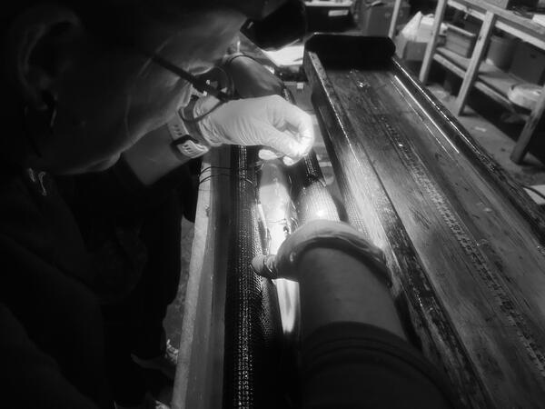
Tagging Round Whitefish
USGS fishery biologist (GLSC; Ashland, Wisconsin) suturing a round whitefish (Prosopium cylindraceum) from Lake Superior as part of an acoustic telemetry project, a type of advanced technology. By tagging the specimen with an acoustic transmitter, the project team will be able to track the fish’s movement around the lake.
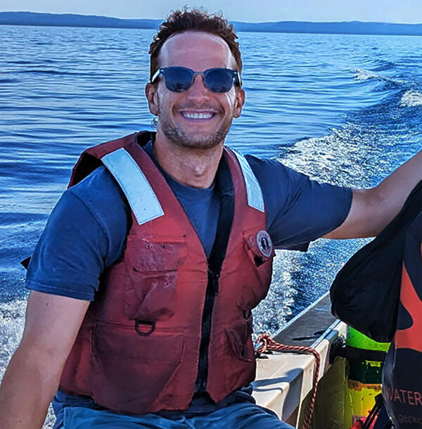
Benjamin Kramer on Lake Michigan in 2025
Dr. Benjamin Kramer is shown on a small research vessel in July 2025 near Sleeping Bear Dunes in Leelanau County, MI collecting benthic mats on Good Harbor Reef as part of USGS's UMESC SWIM (Spawning Whitefish Invasive Mussels) project. Photo Credi: Megan Lewan, USGS
Dr. Benjamin Kramer is shown on a small research vessel in July 2025 near Sleeping Bear Dunes in Leelanau County, MI collecting benthic mats on Good Harbor Reef as part of USGS's UMESC SWIM (Spawning Whitefish Invasive Mussels) project. Photo Credi: Megan Lewan, USGS
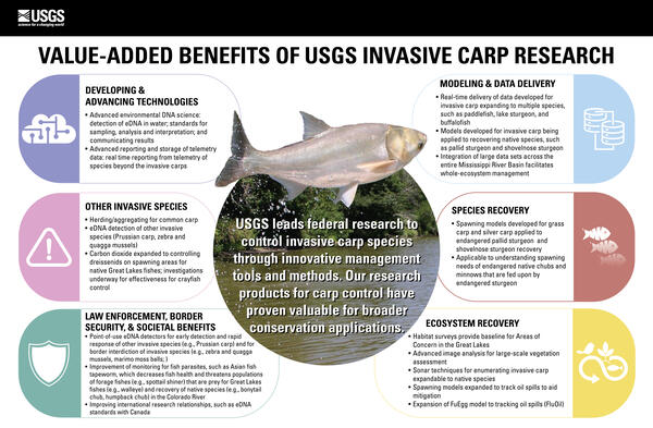
Value-added Benefits of USGS Invasive Carp Research
Value-added Benefits of USGS Invasive Carp ResearchThe USGS leads federal research to control invasive carp species through innovative management tools and methods. Our research products for carp control have proven valuable for broader conservation applications.
DEVELOPING & ADVANCING TECHNOLOGIES

How Fish Hear
Olivia Mitchinson demonstrates alewife otolith removal to participants of angler workshop held at the State University of New York in Oswego. Otoliths are the structures that allow a fish to hear by picking up vibrations in the water. Photo credit: Jacob Bulich, USGS.
Olivia Mitchinson demonstrates alewife otolith removal to participants of angler workshop held at the State University of New York in Oswego. Otoliths are the structures that allow a fish to hear by picking up vibrations in the water. Photo credit: Jacob Bulich, USGS.

Three-Dimensional Data Visualization
Three-dimensional reconstruction of a short section of lakebed imagery into a color point cloud (top) and orthomosaic (bottom), with a zoomed in view (right). These georeferenced data products are typical to many mobile platforms. Photo credit: Phil Wernette, USGS.
Three-dimensional reconstruction of a short section of lakebed imagery into a color point cloud (top) and orthomosaic (bottom), with a zoomed in view (right). These georeferenced data products are typical to many mobile platforms. Photo credit: Phil Wernette, USGS.
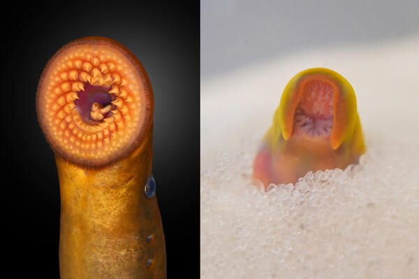
Double Take
The mouth of an adult sea lamprey captured from the Great Lakes (left) and the newly-developing mouth region of a sea lamprey transformer growing in experimental substrate at the USGS Hammond Bay Biological Station (GLSC; Millersburg, Michigan) as part of the Sea Lamprey Aquaculture and Procurement (SLAP) project.
The mouth of an adult sea lamprey captured from the Great Lakes (left) and the newly-developing mouth region of a sea lamprey transformer growing in experimental substrate at the USGS Hammond Bay Biological Station (GLSC; Millersburg, Michigan) as part of the Sea Lamprey Aquaculture and Procurement (SLAP) project.
Videos

Saildrone Deployment on Lake Erie, July 2023
This video shows a Saildrone Explorer in the harbor and being towed out onto Lake Erie for the beginning of a mission to collect data to improve fishery surveys on July 14, 2023.
This video shows a Saildrone Explorer in the harbor and being towed out onto Lake Erie for the beginning of a mission to collect data to improve fishery surveys on July 14, 2023.

Phragmites Adaptive Management Framework: Model Overview
Phragmites Adaptive Management Framework: Model OverviewThis animation is the third video in a series explaining different aspects of the Phragmites Adaptive Management Framework (PAMF). This video focuses on the machine learning model that PAMF uses to systematically learn from participant's data and then provide site-specific management guidance in return.

10 frame 3D reconstruction
Digital 3D reconstruction of lake bottom using 10 photo frames taken by the dive camera system. This reconstruction allows us to gain more insight about the lake bottom since elevation has been added to the photographs.
Digital 3D reconstruction of lake bottom using 10 photo frames taken by the dive camera system. This reconstruction allows us to gain more insight about the lake bottom since elevation has been added to the photographs.

50 frame 3D reconstruction
Digital 3D reconstruction of lake bottom using 50 photo frames taken by the dive camera system. This example shows an arc since the sampling transect is a circle. This reconstruction allows us to gain more insight about the lake bottom since elevation has been added to the photographs.
Digital 3D reconstruction of lake bottom using 50 photo frames taken by the dive camera system. This example shows an arc since the sampling transect is a circle. This reconstruction allows us to gain more insight about the lake bottom since elevation has been added to the photographs.

Playing with a Crayfish Before Sampling
Close up of crayfish next to center pivot. When crayfish swims away, then a diver can be seen next to the center pivot attaching the line for the dive camera transects.
Close up of crayfish next to center pivot. When crayfish swims away, then a diver can be seen next to the center pivot attaching the line for the dive camera transects.
Partial Transect with Dive Camera
Photos taken by the dive camera system of the lake bottom covering sections of sandy and rocky substrate with lots of dreissenid mussels dead and alive.
Photos taken by the dive camera system of the lake bottom covering sections of sandy and rocky substrate with lots of dreissenid mussels dead and alive.