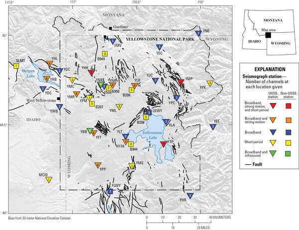
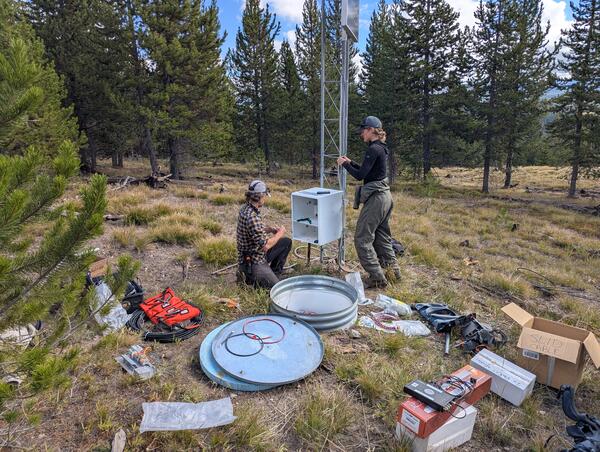
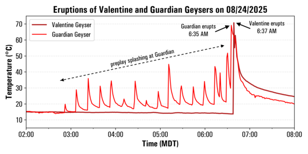
U.S. flag

An official website of the United States government

Images

Images related to Yellowstone Volcano Observatory.

Filter Total Items: 612
Map showing the geologic domains of the Greater Yellowstone Ecosystem in differing colors
Geologic domains of the Greater Yellowstone Ecosystem

Map of the geologic domains of the Greater Yellowstone Ecosystem (GYE). Boundaries are approximate.

Map of the geologic domains of the Greater Yellowstone Ecosystem (GYE). Boundaries are approximate.

Shaded relief map of the Yellowstone region showing earthquakes during the year 2024 as red dots
Map of earthquakes in the Yellowstone National Park region in 2024

Map of seismicity (red circles) in the Yellowstone region during 2024. Gray lines are roads, black dashed line shows the caldera boundary, Yellowstone National Park is outlined by black dot-dashed line, and gray dashed lines denote state boundaries.

Map of seismicity (red circles) in the Yellowstone region during 2024. Gray lines are roads, black dashed line shows the caldera boundary, Yellowstone National Park is outlined by black dot-dashed line, and gray dashed lines denote state boundaries.

Graphic with two panels. Top shows steep subduction. Bottom shows flat-slab subduction
Comparison of steep subduction and flat-slab subduction

Comparison of steep subduction (like that occurring today beneath the Pacific Northwest of the United States) and flat-slab subduction (which led to the formation of the Rocky Mountains a few tens of millions of years ago). Black arrows indicate the relative direction of movement of the oceanic plate.

Comparison of steep subduction (like that occurring today beneath the Pacific Northwest of the United States) and flat-slab subduction (which led to the formation of the Rocky Mountains a few tens of millions of years ago). Black arrows indicate the relative direction of movement of the oceanic plate.

Schematic showing magma storage beneath Yellowstone caldera as colored shapes
Schematic showing magma storage beneath Yellowstone caldera based on magnetotelluric data

Schematic showing magma storage beneath Yellowstone caldera. Nested calderas resulting from the Huckleberry Ridge Tuff, Mesa Falls Tuff, and Lava Creek Tuff caldera forming eruptions are shown as solid black, green, and orange lines, respectively.

Schematic showing magma storage beneath Yellowstone caldera. Nested calderas resulting from the Huckleberry Ridge Tuff, Mesa Falls Tuff, and Lava Creek Tuff caldera forming eruptions are shown as solid black, green, and orange lines, respectively.

Vegetation history based on pollen records from three small lakes on different geological substrates in Yellowstone National
Vegetation history based on pollen records from three small lakes on different geological substrates in Yellowstone National Park

Vegetation history based on pollen records from three small lakes on different geological substrates in Yellowstone National Park.   Blue is open vegetation, light green is parkland, dark green is forest.  Top plot is from Slough Creek Pond, in a present grassland area dominated by glacial and lake sediment in the northeast part of Yellowstone Nationa

Vegetation history based on pollen records from three small lakes on different geological substrates in Yellowstone National Park.   Blue is open vegetation, light green is parkland, dark green is forest.  Top plot is from Slough Creek Pond, in a present grassland area dominated by glacial and lake sediment in the northeast part of Yellowstone Nationa

Three-panel figure showing scrubland vegetation (left), conifers (center), and lodgepole pines (right)
Modern vegetation on different geological substrates in Yellowstone

Modern vegetation on different geological substrates in Yellowstone.  Left: steppe/grassland on glacial clay found in places like Lamar and Hayden Valleys.  Center: Mixed conifer forest in the Absaroka andesite volcanic field in the eastern part of Yellowstone National Park.  Right: Lodgepole pine forest on Central Plateau rhyolite (hydrothermal grass

Modern vegetation on different geological substrates in Yellowstone.  Left: steppe/grassland on glacial clay found in places like Lamar and Hayden Valleys.  Center: Mixed conifer forest in the Absaroka andesite volcanic field in the eastern part of Yellowstone National Park.  Right: Lodgepole pine forest on Central Plateau rhyolite (hydrothermal grass

Graphic showing how InSAR detects ground deformation

Graphic showing how InSAR detects ground deformation by measuring changes in the signal that bounces off the Earth. Figure by the EarthScope Consortium.

Graphic showing how InSAR detects ground deformation by measuring changes in the signal that bounces off the Earth. Figure by the EarthScope Consortium.

Bathymetric map of the West Thumb Basin, Yellowstone National Park

Bathymetric map of the West Thumb Basin showing numerous mapped active or inactive hydrothermal vent sites (small white circles) and sampled hot springs (white stars or larger white circles) and sediment cores (yellow diamonds).  The white-black line represents the 160,000-year-old West Thumb Caldera margin.  West Thumb Geyser Basin is near the southern en

Bathymetric map of the West Thumb Basin showing numerous mapped active or inactive hydrothermal vent sites (small white circles) and sampled hot springs (white stars or larger white circles) and sediment cores (yellow diamonds).  The white-black line represents the 160,000-year-old West Thumb Caldera margin.  West Thumb Geyser Basin is near the southern en

Plot showing frequency of rhyolite eruptions in the Yellowstone region over the past 1.3 million years
Schematic summary of rhyolite eruptions in the Yellowstone Plateau volcanic field over the past 1.3 million years

Schematic summary of rhyolite eruptions in the Yellowstone Plateau volcanic field over the past 1.3 million years. Smaller rhyolite eruptions are known intracaldera eruptions, meaning they occurred within existing caldera structures. Additional rhyolite eruptions that occurred outside the caldera are not included in the figure.

Schematic summary of rhyolite eruptions in the Yellowstone Plateau volcanic field over the past 1.3 million years. Smaller rhyolite eruptions are known intracaldera eruptions, meaning they occurred within existing caldera structures. Additional rhyolite eruptions that occurred outside the caldera are not included in the figure.

A brass-disk benchmark set in the top of a concrete post.  Mark is stamped "C9 1923 7337.580"
Benchmark C9, near Apollinaris Spring in Yellowstone National Park

Benchmark C9, installed by the US Coast and Geodetic Survey (now the National Geodetic Survey) in 1923 near Apollinaris Spring in Yellowstone National Park.  The number stamped into the mark, “7337.580,” is the elevation in feet that was determined by surveys the year the benchmark was established.  USGS photo by Michael Poland, September 4, 2024.

Benchmark C9, installed by the US Coast and Geodetic Survey (now the National Geodetic Survey) in 1923 near Apollinaris Spring in Yellowstone National Park.  The number stamped into the mark, “7337.580,” is the elevation in feet that was determined by surveys the year the benchmark was established.  USGS photo by Michael Poland, September 4, 2024.

Satellite images of a small lake in April and August 2024. The lake is surrounded by trees and, on one side, a geyser basin.
Satellite images of Nupahr Lake, Norris Geyser Basin, in 2024

High-resolution satellite images of Norris Geyser Basin showing the area of Porcelain Basin and Nuphar Lake (both images cover the same area).  In the left image, acquired on April 2, 2024, springs on Porcelain Terrace are full of water, and warm hydrothermal water is flowing into Nuphar Lake from the area circled in yellow.  This warm water kept the north

High-resolution satellite images of Norris Geyser Basin showing the area of Porcelain Basin and Nuphar Lake (both images cover the same area).  In the left image, acquired on April 2, 2024, springs on Porcelain Terrace are full of water, and warm hydrothermal water is flowing into Nuphar Lake from the area circled in yellow.  This warm water kept the north

Dead lodgepole pine trees along the shoreline of a small lake.  Live trees are present away from the shore.
Dead trees along the edge of Nuphar Lake, Yellowstone National Park, in summer 2024

Photo of dead trees along the edge of Nuphar Lake.  The white staining at the base of the trees is a telltale sign that the trees were immersed in thermal water containing silica.  USGS photo by Mike Poland, September 1, 2024.

Photo of dead trees along the edge of Nuphar Lake.  The white staining at the base of the trees is a telltale sign that the trees were immersed in thermal water containing silica.  USGS photo by Mike Poland, September 1, 2024.

Marsh in the foreground, treed hill in the background. Steam vent at base of hill. Blue sky above.
New steam vent that formed in 2024 near Nymph Lake, Yellowstone National Park

New steam vent at the base of a hill north of Nymph Lake, west of the highway and between Norris Geyser Basin and Roaring Mountain. USGS photo by Mike Poland, September 1, 2024.

New steam vent at the base of a hill north of Nymph Lake, west of the highway and between Norris Geyser Basin and Roaring Mountain. USGS photo by Mike Poland, September 1, 2024.

A man in a green shirt is building a gauge for rapid deployment. The gauge is a large black box, sitting on a workbench.
USGS response to Tropical Storm Debby in Georgia

Drew Robinson, a USGS hydrological technician, is putting a Rapid Deployment Gauge together for the Georgia Department of Transportation on Wednesday, August 7. He built the RDG and deployed it in Statesboro in the early evening. That RDG was used to help the local community experiencing bad floods on Lotts Creek.

Drew Robinson, a USGS hydrological technician, is putting a Rapid Deployment Gauge together for the Georgia Department of Transportation on Wednesday, August 7. He built the RDG and deployed it in Statesboro in the early evening. That RDG was used to help the local community experiencing bad floods on Lotts Creek.

Photomicrograph showing a quartz-hosted embayment from the Mesa Falls Tuff, accompanied by a map showing the location of the tuff in eastern Idaho.
Quartz-hosted embayment from the Mesa Falls Tuff

(A) Photomicrograph of a quartz-hosted embayment from the Mesa Falls Tuff. “MI” indicates a glassy inclusion of melt within the crystal. (B) Thickness (in centimeters) and extent of the Mesa Falls ash flow deposit (pink areas) and its source, Henrys Fork Caldera (dashed line).  Figure by Kenneth Befus, University of Texas at Austin.

(A) Photomicrograph of a quartz-hosted embayment from the Mesa Falls Tuff. “MI” indicates a glassy inclusion of melt within the crystal. (B) Thickness (in centimeters) and extent of the Mesa Falls ash flow deposit (pink areas) and its source, Henrys Fork Caldera (dashed line).  Figure by Kenneth Befus, University of Texas at Austin.

Photomicrograph showing water distribution in a quartz-hosted embayment, with greater concentrations at the embayment mouth. Includes a plot showing that the temperature in which the water circulated must have been about 500 degrees Celsius.
Water distribution in a quartz-hosted embayment from the Mesa Falls Tuff

(A) Water distribution in a quartz-hosted embayment measured with synchrotron Fourier Transform Infrared spectroscopy. Warmer colors indicate higher concentrations of water.  Dashed line shows a transect of water content that is modeled in panel (B) to indicate that the emplacement temperature of the ash flow deposit must have been about 500 °C (930 °F).

(A) Water distribution in a quartz-hosted embayment measured with synchrotron Fourier Transform Infrared spectroscopy. Warmer colors indicate higher concentrations of water.  Dashed line shows a transect of water content that is modeled in panel (B) to indicate that the emplacement temperature of the ash flow deposit must have been about 500 °C (930 °F).

Shaded relief location map for the East Gallatin-Reese Creek fault system in northwest Yellowstone National Park

Shaded relief location map for the East Gallatin-Reese Creek fault system (EGRCFS) in northwest Yellowstone National Park (YNP). The location of the EGRCFS is shown as mapped in the U.S.

Shaded relief location map for the East Gallatin-Reese Creek fault system (EGRCFS) in northwest Yellowstone National Park (YNP). The location of the EGRCFS is shown as mapped in the U.S.

Lidar hillshade maps of fault scarps that offset Pinedale glacial till along the East Gallatin-Reese Creek fault system, Yellowstone National Park

Lidar hillshade maps of fault scarps that offset Pinedale glacial till along the East Gallatin-Reese Creek fault system (EGRCFS) near Fawn Creek (A) and Panther Creek (B). Fault scarps are visible as darker lineaments in the hillshade and are marked by the black arrows. Red rectangles on inset maps show location along the EGRCFS.

Lidar hillshade maps of fault scarps that offset Pinedale glacial till along the East Gallatin-Reese Creek fault system (EGRCFS) near Fawn Creek (A) and Panther Creek (B). Fault scarps are visible as darker lineaments in the hillshade and are marked by the black arrows. Red rectangles on inset maps show location along the EGRCFS.

Plot of size versus annual probability for hydrothermal explosion craters in Yellowstone National Park

Plot of size versus annual probability for hydrothermal explosion craters in Yellowstone National Park. The line is a model based on the energy required to form a crater of a specific size, and it is fit to known hydrothermal explosion craters in Yellowstone National Park.

Plot of size versus annual probability for hydrothermal explosion craters in Yellowstone National Park. The line is a model based on the energy required to form a crater of a specific size, and it is fit to known hydrothermal explosion craters in Yellowstone National Park.

Graph showing explosions recorded at Black Diamond Pool in Biscuit Basin, Yellowstone National Park, during 2006 through 2016

Graph showing explosions recorded at Black Diamond Pool in Biscuit Basin, Yellowstone National Park, during 2006 through 2016. Confirmed events refer to eruptions that were witnessed, recorded by temperature loggers, or inferred from their aftermath. Unconfirmed events refer to eruptions that were questionable or might have been misattributed to Black Diamond.

Graph showing explosions recorded at Black Diamond Pool in Biscuit Basin, Yellowstone National Park, during 2006 through 2016. Confirmed events refer to eruptions that were witnessed, recorded by temperature loggers, or inferred from their aftermath. Unconfirmed events refer to eruptions that were questionable or might have been misattributed to Black Diamond.

Frothy blue-green mud pots surrounded by grassy areas. Trees and Yellowstone Lake in the background under partly cloudy sky.
Mud pots in West Thumb Geyser Basin, Yellowstone National Park

Mud pots form in a few selected areas of West Thumb Geyser Basin where low-pH acidic fluids dissolve rocks and soil to produce clay-rich muds.  USGS photo by Pat Shanks, 2024.

Mud pots form in a few selected areas of West Thumb Geyser Basin where low-pH acidic fluids dissolve rocks and soil to produce clay-rich muds.  USGS photo by Pat Shanks, 2024.

Was this page helpful?