
Map of the northwestern U.S., showing the approximate locations of Yellowstone hotspot volcanic fields (orange) and Columbia River Basalts (gray). Boundary of Yellowstone National Park is shown in yellow. Modified from Barry et al. (GSA Special Paper 497, p.
Images
Images related to Yellowstone Volcano Observatory.
Filter Total Items: 710

Locations of Yellowstone hotspot volcanic fields
Map of the northwestern U.S., showing the approximate locations of Yellowstone hotspot volcanic fields (orange) and Columbia River Basalts (gray). Boundary of Yellowstone National Park is shown in yellow. Modified from Barry et al. (GSA Special Paper 497, p.

Geological Map of the Monument Geyser Basin area
Geological Map of the area around Monument Geyser Basin and Beryl Spring, taken from the Geological Map of the Yellowstone Plateau Area (Christiansen, 2001)
Geological Map of the area around Monument Geyser Basin and Beryl Spring, taken from the Geological Map of the Yellowstone Plateau Area (Christiansen, 2001)
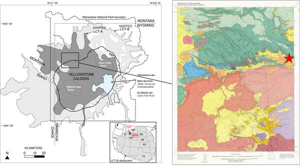
Map of Yellowstone showing the extent of Lava Creek Tuff and geologic map of Madison Junction area
Map of Yellowstone showing the extent of Lava Creek Tuff and geologic map of Madison Junction areaLeft: Map of Yellowstone showing the extent of mapped Lava Creek Tuff members A and B, which erupted during the formation of Yellowstone Caldera about 631,000 years ago. Right: Geologic map of Madison Junction (1:125,000).

Landsat-7 satellite image of Jemez Mountains and Valles Caldera, New Mexico
Landsat-7 satellite image of Jemez Mountains and Valles Caldera, New MexicoLandsat-7 satellite image of Jemez Mountains and Valles Caldera, New Mexico. The Valles and Toledo Caldera margins are approximated by dashed yellow lines, and the resurgent dome and lava domes are labeled. The Banco Bonito lava flow is the youngest in the region at 68,000 years old. The town of Los Alamos is located just east of the caldera.

Schematic illustration showing the 1912 Novarupta eruption in Alaska and the caldera collapse at Mount Katmai
Schematic illustration showing the 1912 Novarupta eruption in Alaska and the caldera collapse at Mount KatmaiSchematic illustration showing the 1912 Novarupta eruption in Alaska and the caldera collapse at Mount Katmai, 10.6 km (about 6.6 miles) to the northeast.

View from the SE rim of McDermitt caldera, Nevada and Oregon, of the Thacker Pass area
View from the SE rim of McDermitt caldera, Nevada and Oregon, of the Thacker Pass areaView from the SE rim of McDermitt caldera, Nevada and Oregon, showing rhyolite lavas overlain by thin outflow McDermitt Tuff in the south wall of the caldera. The low area that makes up most of the photo is intracaldera tuffaceous sediment. This is Thacker Pass, the site of largest and highest-grade lithium deposits in the region.

Rheomorphism in outflow sheets of McDermitt Tuff, Nevada and Oregon
Rheomorphism in outflow sheets of McDermitt Tuff, Nevada and OregonFolds in outflow sheets of McDermitt Tuff, from the eruption that formed McDermitt Caldera in Nevada and Oregon about 16.4 million years ago. The folding is called “rheomorphism” and occurred as the hot ash deposit flowed under its own weight shortly after it was deposited over preexisting topographic highs and lows. The texture resembles that of rhyolit

Mount Epomeo on the island of Ischia
Mount Epomeo on the island of Ischia. The visible western slope of the resurgent block consists of 55,000 year old rocks that formed one of the most widespread Late Quaternary pyroclastic deposits in the Mediterranean region. INGV photo (https://www.ingv.it/en/Ischia).
Mount Epomeo on the island of Ischia. The visible western slope of the resurgent block consists of 55,000 year old rocks that formed one of the most widespread Late Quaternary pyroclastic deposits in the Mediterranean region. INGV photo (https://www.ingv.it/en/Ischia).

Agua Shuca thermal area, El Salvador
Steam rises above a hot pool at Agua Shuca, one of many thermal areas of the Ahuachapán geothermal field of El Salvador. A sudden hydrothermal explosion at Agua Shuca in October 1990 ejected steam and debris within a 200-m-radius, and about 25 people living adjacent to the thermal area were killed.
Steam rises above a hot pool at Agua Shuca, one of many thermal areas of the Ahuachapán geothermal field of El Salvador. A sudden hydrothermal explosion at Agua Shuca in October 1990 ejected steam and debris within a 200-m-radius, and about 25 people living adjacent to the thermal area were killed.
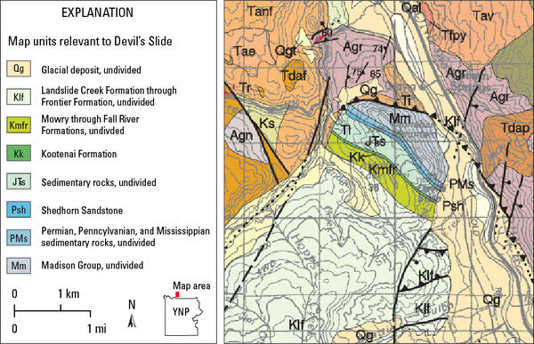
Excerpt from the MBMG Geological Map of the Gardiner 30’ x 60’ Quadrangle
Excerpt from the MBMG Geological Map of the Gardiner 30’ x 60’ QuadrangleExcerpt from the Geological Map of the Gardiner 30’ x 60’ Quadrangle, South-Central Montana, by Berg and others (1999), focused on Devil’s Slide (colorful blue-green stripes at center of map excerpt). Full unit description and map available online as Montana Bureau of Miles and Geology Open File No.

Geologists in Little Dipper boat on Grand Prismatic Spring
Geologists in Little Dipper boat on Grand Prismatic SpringYellowstone National Park employees Rick Hutchinson (right) and Jim Peaco (left) guide the specially designed Little Dipper boat into the boiling waters of Grand Prismatic Spring to collect measurements of the temperature and structure of the feature. National Park Service photo by Josh Robbins in 1996.

Queen's Laundry bathhouse, in Yellowstone's Lower Geyser Basin
Queen's Laundry bathhouse, in Yellowstone's Lower Geyser BasinQueen's Laundry bathhouse, in the Lower Geyser Basin of Yellowstone National Park. Building began under superintendent Philetus Norris in 1881 but was never finished.
Queen's Laundry bathhouse, in Yellowstone's Lower Geyser Basin
Queen's Laundry bathhouse, in Yellowstone's Lower Geyser BasinQueen's Laundry bathhouse, in the Lower Geyser Basin of Yellowstone National Park. Building began under superintendent Philetus Norris in 1881 but was never finished.

Cross section of the Western Snake River Plain, Idaho
Cross section of the Western Snake River Plain, IdahoCross section of the Western Snake River Plain, Idaho.
Cross section of the Western Snake River Plain, Idaho
Cross section of the Western Snake River Plain, IdahoCross section of the Western Snake River Plain, Idaho.

Gas plume rises above lava fountains in a lava lake in the summit crater of Nyiragongo volcano, Democratic Republic of the Congo, on 20 August 1994
Gas plume rises above lava fountains in a lava lake in the summit crater of Nyiragongo volcano, Democratic Republic of the Congo, on 20 August 1994A gas plume rises above lava fountains in a lava lake in the summit crater of Nyiragongo volcano on 20 August 1994. USGS photo by Jack Lockwood.

Geologic map of the Wind River Range, Wyoming
Geologic map of the Wind River Range from Blackstone, 1993 (The Wind River Range, Wyoming: An Overview. Wyoming Geological Association. Jubilee Anniversary Field Conference Guidebook: Wyoming Geology, Past, Present, and Future. Pg. 121-140).
Geologic map of the Wind River Range from Blackstone, 1993 (The Wind River Range, Wyoming: An Overview. Wyoming Geological Association. Jubilee Anniversary Field Conference Guidebook: Wyoming Geology, Past, Present, and Future. Pg. 121-140).

Deep-ocean hydrothermal vent system from the East Pacific Rise
Deep-ocean hydrothermal vent system from the East Pacific RisePhoto of a deep-ocean hydrothermal vent system from the East Pacific Rise at 9º39’N latitude and 2550 m (8366 ft) depth showing vigorously venting “black smoker” hydrothermal fluids (329 °C, or 624 °F) that are dark gray to black due to rapid precipitation of iron, copper, and zinc sulfide minerals as the hot water mixes with cold bottom waters.

Track of the Yellowstone hotspot showing the ages and locations of volcanic fields
Track of the Yellowstone hotspot showing the ages and locations of volcanic fieldsColor-shaded relief topographic map of the track of the Yellowstone hotspot showing the ages and locations of volcanic fields and faulting patterns which become younger to the northeast. Areas in cooler colors (greens and blues) represent low topographic elevations, whereas warmer colors (oranges and reds) represent high elevations. Adapted from

Porkchop Geyser erupting in August 1989
Porkchop Geyser erupting in August 1989.

Ice cone at Porkchop Geyser in March 1989
Ice cone at Porkchop Geyser in March 1989.

Apollinaris Spring, Yellowstone National Park, in 1987
Apollinaris Spring, Yellowstone National Park, in 1987Apollinaris Spring in 1987. The spring was modified in 1925 so that water would flow through pipes to be emitted from a rock wall. Yellowstone National Park photo by Jim Peaco.
Apollinaris Spring, Yellowstone National Park, in 1987
Apollinaris Spring, Yellowstone National Park, in 1987Apollinaris Spring in 1987. The spring was modified in 1925 so that water would flow through pipes to be emitted from a rock wall. Yellowstone National Park photo by Jim Peaco.
![La Garita Mountain (elevation 4179 m [13711 ft]), Colorado](https://d9-wret.s3.us-west-2.amazonaws.com/assets/palladium/production/s3fs-public/styles/masonry/public/media/images/Fig_5.32_LaGaritaMtns%20copy.jpeg?itok=G-UD0FEM)
La Garita Mountain (elevation 4179 m [13711 ft]), Colorado
La Garita Mountain (elevation 4179 m [13711 ft]), ColoradoLa Garita Mountain (elevation 4179 m [13711 ft]), Colorado. The mountain is a resurgent block of Fish Canyon Tuff that is more than 1 km (0.6 mi) thick—the top is eroded and the base is not exposed. The tuff formed during the eruption of La Garita caldera about 27.8 million years ago and has a volume of more than 5000 km3 (1200 mi3)