U.S. flag

An official website of the United States government

Images

Kīlauea images of eruptive activity, field work, and more.

Filter Total Items: 2978
Color photograph showing fallout area from volcanic eruption
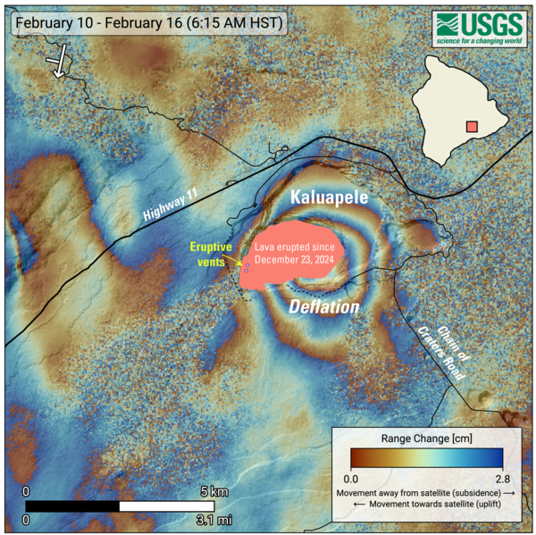
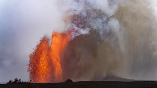
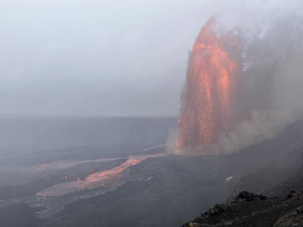
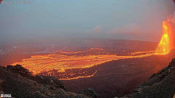
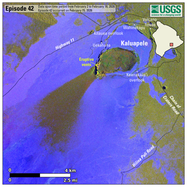
February 18, 2026 — Kīlauea lava flow and tephra fall map following episode 24

This map shows lava flow and tephra accumulation at the summit of Kīlauea volcano associated with episode 42 of the ongoing eruption in Halemaʻumaʻu that started on December 23, 2024, using data recorded by the Italian Space Agency's (ASI) COSMO-SkyMed Second Generation satellite constellation.

This map shows lava flow and tephra accumulation at the summit of Kīlauea volcano associated with episode 42 of the ongoing eruption in Halemaʻumaʻu that started on December 23, 2024, using data recorded by the Italian Space Agency's (ASI) COSMO-SkyMed Second Generation satellite constellation.

Color photograph showing volcanic material accumulated on vehicle
February 16, 2026 — Kīlauea episode 42 ash in Pāhala

Tephra accumulated in the community of Pāhala, about 18.5 miles (30 km) to the southwest of north and south vents in Halema‘uma‘u crater at the summit of Kīlauea. A few hours after episode 42 started on February 15, 2026, fine ash of less than 0.03 inch (1 mm) diameter began to accumulate on surfaces.

Tephra accumulated in the community of Pāhala, about 18.5 miles (30 km) to the southwest of north and south vents in Halema‘uma‘u crater at the summit of Kīlauea. A few hours after episode 42 started on February 15, 2026, fine ash of less than 0.03 inch (1 mm) diameter began to accumulate on surfaces.

Color photograph of strands of volcanic glass in a hand
February 17, 2026 — Kīlauea episode 42 Pele's hair in Pāhala

Long strands of Pele's hair, which is made of volcanic glass, drifted on the wind to the southwest during episode 42 of Kīlauea summit lava fountaining on February 15, 2026. This photo shows a bundle of these long strands of Pele's hair after they had blown around in the wind in the community of Pāhala and became tangled up. USGS photo by D. Downs.

Long strands of Pele's hair, which is made of volcanic glass, drifted on the wind to the southwest during episode 42 of Kīlauea summit lava fountaining on February 15, 2026. This photo shows a bundle of these long strands of Pele's hair after they had blown around in the wind in the community of Pāhala and became tangled up. USGS photo by D. Downs.

Color photograph of lava fountain
February 15, 2026 — Side-by-side lava fountains during episode 42 at the summit of Kīlauea

Late in the afternoon on Sunday, February 15, USGS Hawaiian Volcano Observatory scientists monitoring Kīlauea summit eruption episode 42 hiked west of Halema‘uma‘u crater for an angle of both the north and south vent lava fountains side by side. During most of episode, the south vent lava fountain (right) was slightly taller than the north vent's (left).

Late in the afternoon on Sunday, February 15, USGS Hawaiian Volcano Observatory scientists monitoring Kīlauea summit eruption episode 42 hiked west of Halema‘uma‘u crater for an angle of both the north and south vent lava fountains side by side. During most of episode, the south vent lava fountain (right) was slightly taller than the north vent's (left).

Color photograph of lava fountain in mist
February 15, 2026 — North vent channel realignment during episode 42 at Kīlauea summit

On Sunday, February 15, USGS Hawaiian Volcano Observatory scientists monitored episode 42 of the Kīlauea summit eruption from the northwest rim of Halema‘uma‘u crater. Despite driving rains, this location provided good views of the north vent's lava fountains and flows on the crater floor. Around 4:20 p.m.

On Sunday, February 15, USGS Hawaiian Volcano Observatory scientists monitored episode 42 of the Kīlauea summit eruption from the northwest rim of Halema‘uma‘u crater. Despite driving rains, this location provided good views of the north vent's lava fountains and flows on the crater floor. Around 4:20 p.m.

Color telephoto of base of lava fountain
February 15, 2026 — Kīlauea fountain bases during episode 42

A telephoto view of the base of the two lava fountains, and the narrow gap that was present between them, during episode 42 of the Kīlauea summit eruption on February 15, 2026. On the south side of the north fountain (right), a very small third fountain was active, with frequent bubble bursting. USGS photo by M. Patrick.

A telephoto view of the base of the two lava fountains, and the narrow gap that was present between them, during episode 42 of the Kīlauea summit eruption on February 15, 2026. On the south side of the north fountain (right), a very small third fountain was active, with frequent bubble bursting. USGS photo by M. Patrick.

Color photograph of lava fountain feeding lava flows on the floor of a crater
February 15, 2026 — Kīlauea episode 42 from the KWcam

The KWcam is located on the northwest rim of Halemaʻumaʻu crater at the summit of Kīlauea. The camera is one of many located around the Kaluapele, Kīlauea summit caldera, that aid in monitoring conditions. This image was captured 6:26 p.m. on February 15, 2026, during episode 42 of lava fountaining. USGS photo. 

The KWcam is located on the northwest rim of Halemaʻumaʻu crater at the summit of Kīlauea. The camera is one of many located around the Kaluapele, Kīlauea summit caldera, that aid in monitoring conditions. This image was captured 6:26 p.m. on February 15, 2026, during episode 42 of lava fountaining. USGS photo. 

Color photograph showing clasts in a lava fountain
February 15, 2026 — Semi-molten clasts from the north vent fountain feed into lava flow at Kīlauea during episode 42

Photograph of the north vent fountain during episode 42, taken from the northwest rim of Halema‘uma‘u crater on February 15, 2026. Semi-molten clasts feed a small ‘a‘ā lava flow carrying lava north from the base of the north vent lava fountain within the caldera.

Color telephoto of lava fountain
February 15, 2026 — Kīlauea episode 42 lava fountains

A telephoto view of the south vent fountain, taken from the south rim of Halema‘uma‘u crater at night on February 15, 2026. Molten clasts falling near the base of the fountain were feeding a channelized flow that carried lava into the eastern portion of the crater.

A telephoto view of the south vent fountain, taken from the south rim of Halema‘uma‘u crater at night on February 15, 2026. Molten clasts falling near the base of the fountain were feeding a channelized flow that carried lava into the eastern portion of the crater.

Color telephoto showing the top of lava fountains
February 15, 2026 — Kīlauea fountain tops during episode 42

At brief moments during episode 42 Kīlauea summit lava fountaining on February 15, 2026, the south (left) and north (right) fountains were similar in height, and wispy fingers of gas and small particles from the two fountains mingled in the gap between them. USGS photo by M. Patrick.

At brief moments during episode 42 Kīlauea summit lava fountaining on February 15, 2026, the south (left) and north (right) fountains were similar in height, and wispy fingers of gas and small particles from the two fountains mingled in the gap between them. USGS photo by M. Patrick.

Color photograph of lava fountain
February 15, 2026 — North vent lava fountain during episode 42 at Kīlauea summit

This photo north vent lava fountain during Kīlauea summit eruption episode 42 was captured from the northwest rim of Halema‘uma‘u crater on February 15, 2026.

Color photograph of two lava fountains at night
February 15, 2026 — Kīlauea night time lava fountains during episode 42

This night-time photo shows north and south vent lava fountains at the summit of Kīlauea, from the south rim of the Halema‘uma‘u crater. The south fountain (left) was fluctuating in height over timescales of seconds. At the bottom of the photo, a spatter-fed ‘a‘ā flow slowly advances, with clinker collapsing along its front. USGS photo by M. Patrick.

This night-time photo shows north and south vent lava fountains at the summit of Kīlauea, from the south rim of the Halema‘uma‘u crater. The south fountain (left) was fluctuating in height over timescales of seconds. At the bottom of the photo, a spatter-fed ‘a‘ā flow slowly advances, with clinker collapsing along its front. USGS photo by M. Patrick.

Color photograph of lava fountain
February 15, 2026 — Semi-molten clasts falling from the north vent feed into Kīlauea lava flow during episode 42

Photograph of the north vent fountain during episode 42, taken from the northwest rim of Halema‘uma‘u crater on February 15, 2026. Semi-molten clasts feed a small ‘a‘ā lava flow carrying lava north from the base of the north vent lava fountain within the caldera.

Color photograph of webcam in the foreground and lava fountains in the background
February 15, 2026 — V3cam monitors Kīlauea lava fountains during episode 42

The V3cam livestream webcam monitors the episode 42 lava fountaining from the south rim of Kīlauea caldera, USGS photo by M. Patrick on February 15, 2026.

Color photograph of caldera
Kīlauea summit caldera from B1 camera on February 6, 2026

View of Kaluapele (Kīlauea's summit caldera) from the B1 webcam on February 6, 2026, acquired between lava fountaining episodes 41 and 42.

Color photograph of tephra clasts outlined by size
Kīlauea lava fountaining episode tephra clast sizes

This annotated photograph shows the different size categories of tephra associated with recent lava fountaining episodes at the summit of Kīlauea. The inset photo on the bottom left shows the vesicular (bubble-rich) texture of most of these clasts. The smallest particles of tephra are volcanic ash, and they are smaller than 1/16 of an inch (2 mm).

This annotated photograph shows the different size categories of tephra associated with recent lava fountaining episodes at the summit of Kīlauea. The inset photo on the bottom left shows the vesicular (bubble-rich) texture of most of these clasts. The smallest particles of tephra are volcanic ash, and they are smaller than 1/16 of an inch (2 mm).

Color photograph of volcanic vents
February 4, 2026 — North and south vents at the summit of Kīlauea

USGS Hawaiian Volcano Observatory geologists captured this view during a morning helicopter monitoring overflight of Kīlauea summit caldera, Kaluapele, on the morning of February 4, 2026. Despite glow present on the USGS livestream cameras overnight, no lava or incandescent material was visible in the north (right) and south (left) vents. USGS photo by D. Downs.

USGS Hawaiian Volcano Observatory geologists captured this view during a morning helicopter monitoring overflight of Kīlauea summit caldera, Kaluapele, on the morning of February 4, 2026. Despite glow present on the USGS livestream cameras overnight, no lava or incandescent material was visible in the north (right) and south (left) vents. USGS photo by D. Downs.

Color photograph of volcano summit
February 4, 2026 — Kīlauea monitoring overflight of the summit

USGS Hawaiian Volcano Observatory staff participated in a monitoring overflight of Kīlauea summit caldera, Kaluapele, the morning of February 4, 2026, to investigate and collect samples of the episode 41 lava flows that were emplaced on January 24, 2026. These lava flows covered most of the crater floor during the lava fountaining episode. USGS photo by D.

USGS Hawaiian Volcano Observatory staff participated in a monitoring overflight of Kīlauea summit caldera, Kaluapele, the morning of February 4, 2026, to investigate and collect samples of the episode 41 lava flows that were emplaced on January 24, 2026. These lava flows covered most of the crater floor during the lava fountaining episode. USGS photo by D.

Color photograph of crystals
Olivine crystals from Kīlauea lava

Image of an olivine crystal taken with a petrographic microscope. A) Olivine with melt inclusion (honey color) with a vapor gas bubble inside it (black circle). B) Zoomed in view of olivine highlighting a fluid inclusion (black circle, white dot in center) and a melt inclusion. USGS images. 

Image of an olivine crystal taken with a petrographic microscope. A) Olivine with melt inclusion (honey color) with a vapor gas bubble inside it (black circle). B) Zoomed in view of olivine highlighting a fluid inclusion (black circle, white dot in center) and a melt inclusion. USGS images. 

Color map showing area of volcanic fallout
January 29, 2026—Summary map of tephra fall after episode 41 lava fountaining at the summit of Kīlauea

This map shows the tephra fall associated with episode 41 of Kīlauea's episodic summit eruption, on January 24, 2026. Tephra is a generic word for any material erupted by a volcano that travels through the air before landing on the ground.

Was this page helpful?