



Landsat Science Team: Helping Farmers Monitor Water Use
Yun Yang, a member of the 2026-2030 Landsat Science Team, is working to improve evapotranspiration and albedo estimation.
Agriculture and the Landsat program have a long history together. The satellite Earth observations that began in 1972 provided a vital ability to monitor how crops were growing around the world—and whether shortages might be looming that would affect the food supply.
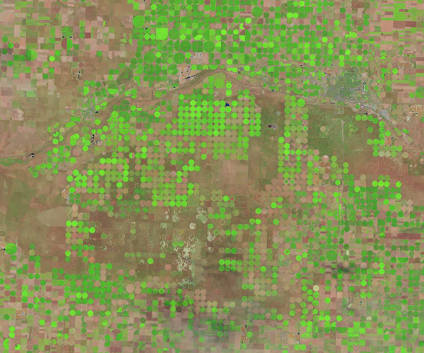
When later Landsat satellites carried thermal instruments to measure land surface temperatures, scientists gained an important tool for estimating how much water was being consumed by crops because evaporation and transpiration (plant “sweat”), collectively known as evapotranspiration (ET), cool down an area.
Today, U.S. farmers and water managers rely on past and current Landsat data as the backbone of models that help them determine how much water the crops are using. This knowledge informs farmers’ decisions about the efficient and wise use of water, along with their responses to reporting requirements.
With drought a recurring reality in some areas and water resources becoming increasingly scarce, improvements in water monitoring are crucial.
Yun Yang, an assistant professor at Cornell University, wants to help make the data even better—more accurate, detailed and timely—to help farmers with their water management decisions.
“This is a really interesting time and also a really urgent time because of increasing water stress,” she said.
A Plan to Improve Evapotranspiration Estimates
Yang’s work involves trying to further enhance ET at the field level. She also serves as a consortium partner and member of the nonprofit board for Landsat-based OpenET, a platform that provides ET information by using six respected ET models to derive an ensemble model that is used throughout the United States.
In addition, ET is the focus of Yang’s interest as a member of the new 2026-2030 Landsat Science Team, a group of federal, academic, international and industry scientists and engineers committed to supporting the scientific integrity, data quality and continuity of the Landsat mission.
Yang sees great potential in integrating data from other remote sensing sources with Landsat data to improve ET products.
As a first step for her work related to the Landsat Science Team, Yang and her colleague Zhuosen Wang want to enhance the estimation of Landsat albedo to use, for demonstration, as an input to ET model ALEXI/DisALEXI, one of the OpenET models. Albedo is a measure of how much incoming solar radiation is reflected by the Earth’s surface. Bright reflective surfaces, such as snow and ice, typically have a high albedo, while darker surfaces, such as forests or dark soil, generally have lower albedo and absorb more solar radiation. Albedo helps determine how much energy is available at the surface for processes such as evapotranspiration.
Together, the Landsat 8 and 9 satellites revisit land and coastal surfaces around the globe every eight days. Adding Europe’s similar Sentinel-2 optical satellite observations via the Harmonized Landsat Sentinel-2 (HLS) product would increase the number of albedo observations to several times a week, allowing changes in surface conditions to be captured more quickly.
As a next step, Yang would like to incorporate the enhanced albedo product into the ALEXI/DisALEXI model, replacing the simpler approach currently used by the model. The work could demonstrate whether more precise albedo information improves ET estimates and could potentially serve as a proving ground for other ET models.
In addition, Yang intends to refine her system that fuses Landsat thermal observations with those from other remote sensing instruments for more frequent observations at a resolution that reveals more detail.
Focus on Farmers
Yang sees mutual benefits to serving with both OpenET and the Landsat Science Team. OpenET puts her in touch with data users, “to really understand what they want and what they need and learn how we can better support them,” and that provides valuable insight for the Landsat Science Team.
Ultimately, the ET efforts aim to give farmers a better idea of how much water their individual fields require. “They can use this ET information to help determine when to start irrigation, how much to irrigate and whether there’s any stress signal from their fields,” Yang said.
While Yang believes other satellite data can help improve ET estimates, Landsat’s unique combination of features still provides the core data.
“Landsat is the gold standard for ET estimation,” Yang said.