



Landsat Science Team: Landsat 10 to Improve Harmful Algal Bloom Monitoring
Ryan O'Shea, a member of the 2026-2030, is focused on developing an algorithm to better detect harmful algal blooms, or HABs.
Harmful algal blooms, or HABs, occur when algae or cyanobacteria grow rapidly. These blooms can wreak havoc in aquatic ecosystems, killing hundreds of thousands of fish, harming people and animals and costing up to $100 million annually in the United States.
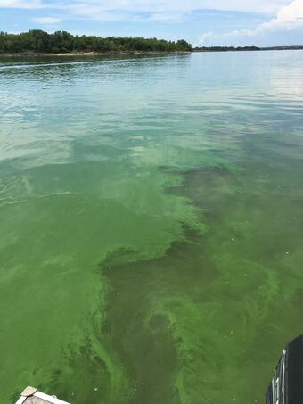
Some HABs (e.g., cyanobacteria) produce dangerous toxins which can cause illness or even death in humans and livestock, while others cause harm to the environment by accumulating excessive biomass, which limits light availability and consumes oxygen during decomposition. These blooms threaten freshwater and coastal waters including lakes, reservoirs, rivers, ponds and bays.
They are a growing threat to aquatic ecosystems with all 50 states reporting HABs, signaling the need for improved methods to monitor water quality.
To do that, water quality managers increasingly use satellite observations to complement field sampling and monitor blooms across large areas. One member of the 2026-2030 Landsat Science Team, Ryan O’Shea, hopes new technologies can advance that mission. When Landsat 10 launches, which is expected in 2031, it will be equipped with 26 spectral bands, 15 more than either Landsat 8 or 9. New and refined bands in the red, violet, orange, red-edge and near infrared spectral regions will improve observations of water quality and aquatic ecosystems.
O’Shea will develop and refine an end-to-end processing pipeline to monitor freshwater and coastal ecosystems using current and future satellite imagery. O’Shea, a lead research scientist at Science Systems and Applications Inc., brings a wealth of expertise to the team, including experience from previous research supporting the U.S. Geological Survey (USGS) and NASA’s Landsat program.
He, along with co-investigators, Dr. Akash Ashapure and Dr. Arun Saranathan, and project personnel William Wainwright, contributed to research funded through the 2018-2023 Landsat Science Team with Dr. Nima Pahlevan by developing and validating machine-learning based atmospheric correction and water quality parameter retrieval algorithms.
“As part of the team previously, I saw the algorithms that we were developing were doing really well at monitoring these fine spatial scales, and I wanted to see that work continue and I’m also really excited about Landsat 10’s capabilities. We’re going to be able to get down to 20-meter scales so we can monitor these harmful algal blooms at fine scales to help monitor small inland bodies as well as tributaries,” O’Shea said.
“I joined the team for the societal benefit,” he added.
Challenges
O’Shea’s proposal builds upon Landsat 8 and 9’s capabilities of detecting algal blooms with sufficient spatial and spectral resolution for consistent water quality monitoring. However, their limited spectral coverage makes it difficult to distinguish cyanobacteria from other phytoplankton, O'Shea said. Landsat 10’s additional spectral bands are expected to improve the consistency and accuracy of bloom monitoring.
“With Landsat 8 and 9, we’re able to get chlorophyll concentration, a pigment that’s a broad indicator of the general biomass of microscopic aquatic plants. But with more specific information that’s going to be available on Landsat 10 and these new bands, we can start to get cyanobacteria data. That can inform water quality managers if these blooms are potentially toxic,” O’Shea said.
Methods
O’Shea’s proposed pipeline includes machine-learning algorithms to process observations of optically complex inland and coastal waters for both current and future Landsat missions. That includes:
- Refining atmospheric correction algorithms and cloud masking approaches for biologically active and optically complex waters to improve bloom monitoring.
- Improving methods for estimating chlorophyll-a concentrations and harmonizing observations from Landsat and international satellites, such as Sentinel-2 and Sentinel-3.
- Developing and distributing a machine-learning based algorithm for high accuracy HAB monitoring in advance of Landsat 10’s launch.
- Updating the Satellite-based Tool for Rapid Evaluation of Aquatic environMents (STREAM) website to support advanced harmonized products.

O’Shea is focusing on improving and validating the accuracy of the algorithms and expanding the geographic coverage of the algorithms beyond North America and Europe.
“I’m doing a lot of work with stakeholders to see how well our algorithms perform in their region and also evaluating a bunch of different algorithms,” O’Shea said. “The accuracy and proof of success help them trust in our algorithms and use it to better direct their resources.”
As research progresses ahead of the Landsat 10 launch, O’Shea said the focus is also on the harmonization of observations from both Landsat and Europe’s Sentinel-2 and Sentinel-3 satellites.
“We’re doing a final push on harmonization between sensors and trying to get similar retrievals from Landsat and Sentinel so we can combine these two together in a time series to get higher temporal resolutions. This will allow water quality managers to have more consistent observations they can work with,” O’Shea said.
As a member of the Landsat Science Team, O’Shea hopes he can bring a voice to the aquatic community.
“Big picture, I see myself advocating for aquatic applications. I know the Landsat Science Team focuses mainly on terrestrial applications, so just making sure that I advocate for design decisions that help support aquatic users in the long term. I’m also hoping to improve our stakeholder use of online platforms so they can integrate it with their decision-making capabilities to better direct their resources,” O’Shea said.