
Latest in Landsat February 2026 - Vol. 5 | Issue 2
USGS Partners with AI/ML Experts to Improve Landsat Flight Operations
Cooperative Research & Development Agreements (CRADAs) in place
2026-2030 Landsat Science Team Introductory Meeting
The newly-installed 2026-2030 Landsat Science Team met virtually in January. After introductions, the goals, expectations, and the projected impacts of the team were discussed. The team will meet soon for their first in-person meeting.
Landsat at Work: Transforming Data into Solutions

Landsat’s satellite imagery provides valuable data used by industries and decision makers in the field, ranging from energy and utilities to agriculture, insurance and more. Landsat’s archive reaches back more than 50 years, providing valuable insights into land, water and environmental conditions that shape planning, management, and response.
Visit this webpage to read a collection of stories highlighting how Landsat data are put into practice to inform decisions that help safeguard lives, property, and natural resources.
Landsat at Work: Transforming Data into Solutions
Working with Landsat Data in the Cloud? New Tutorials are Now Available
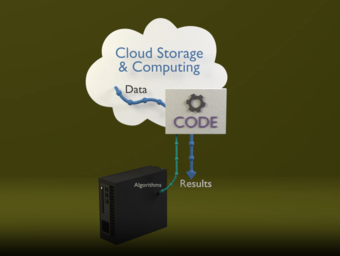
The USGS EROS User Services team recently added several new tutorials to their code repository. These guides help users access and work with Landsat data stored in a commercial cloud environment more effectively.
Some of the tutorials help users just getting started—like how to access Landsat Collection 2 data through the SpatioTemporal Asset Catalog (STAC) in a commercial cloud environment and how to use the USGS/EROS Machine-to-Machine (M2M) Application Programming Interface (API) to efficiently search metadata and acquire the data they need. More knowledgeable users may benefit from the tutorials that describe best practices for radiance-to-reflectance scaling and time-series analysis.
Visit this webpage to learn more about working with Landsat data "in the cloud".
Using Landsat Data: More Helpful Tutorials Now Available
ICYMI: 2025 Highlights from USGS EROS and Landsat
The USGS Earth Resources Observation and Science (EROS) Center and the Landsat Project published the stories below that highlight the activities and accomplishments in 2025. Check them out below!
-
Satellite Data and Science Abound in 2025 Satellite Data and Science Abound in 2025
The USGS Earth Resources Observation and Science (EROS) Center scientists’ work helps save lives and protect property while EROS offers remote sensing data to the world. As the Earth begins its next revolution around the sun, let’s look back at some of the exciting accomplishments at EROS in 2025!
-

Landsat in 2025: Milestones Continue the Mission's Legacy Landsat in 2025: Milestones Continue the Mission's Legacy
In 2025, Landsat celebrated several milestones. We officially bid farewell to Landsat 7 and its 26-year mission and legacy, while continuing to show how Landsat imagery supports real world decision-making through new stories highlighting its role across industries. The year also brought the announcement of a new Landsat Science Team set to begin in 2026. Catch up on our year here.
Helpful Applications

EarthNow! Landsat Image Viewer
The EarthNow! Landsat Image Viewer displays imagery in near real-time as Landsat satellites orbit the Earth. Along with the near real-time video stream, EarthNow! also replays acquisition recordings from previous Landsat overpasses. When Landsat satellites are out of viewing range of a ground station, the most recent overpass is displayed.

Earthshots
The surface of the Earth is always changing. Some changes like earthquakes, volcanoes, floods, and landslides happen quickly, and other changes, such as most erosional processes, happen slowly over time. It’s often hard to see these changes from ground level. Earthshots shows you how satellite data are used to track these changes over time.

Landsat Acquisition Tool
The Landsat Acquisition Tool helps determine when the Landsat satellites acquire data over specific areas of interest, displaying the paths that were acquired on any given day.
Got Questions? We’ve Got Answers!
-

Landsat Frequently Asked Questions Landsat Frequently Asked Questions
This page lists commonly asked questions pertaining to the Landsat satellite missions, the science behind maintaining high quality Landsat data, and what products are available - and how to download them.
Landsat Glossary and Acronyms Landsat Glossary and Acronyms
The Landsat project uses many technical terms and acronyms to describe the satellite systems, sensors, and data formats. This information is vital for interpreting satellite imagery and using Landsat data in research and environmental monitoring. Access this information to locate the terms to learn more!
Connect Connect
Explore the Landsat social media channels, discover the latest news and resources, and find answers to your questions about Landsat Missions, science products, and data access. We are here to help you stay informed!
Stay Informed with the Latest in Landsat Newsletter
Direct to your inbox! Landsat's monthly newsletter features current news, uses, tools, and announcements about America's Earth-observing satellite program.