
Landsat in 2025: Milestones Continue the Mission's Legacy
In 2025, Landsat celebrated several milestones. We officially bid farewell to Landsat 7 and its 26-year mission and legacy, while continuing to show how Landsat imagery supports real world decision-making through new stories highlighting its role across industries. The year also brought the announcement of a new Landsat Science Team set to begin in 2026. Catch up on our year here.
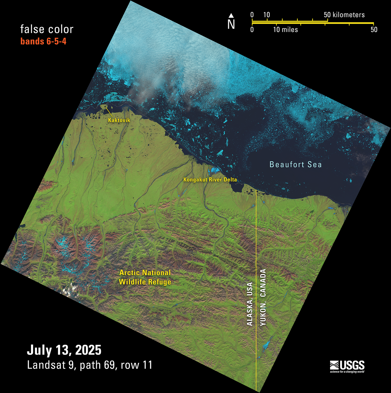
Landsat 9 Reaches a Million
On July 13, 2025, the USGS Earth Resources Observation and Science (EROS) Center captured and processed the 1 millionth Landsat 9 Level-1 product. This image of Alaska’s northern shoreline along the U.S./Canadian border is one of hundreds that were captured and processed on that day.

Landsat 9, along with its counterpart Landsat 8, holds a vital role in our understanding and management of America’s natural resources. Areas that benefit from Landsat include water and food security, agriculture, disaster response, land use/land change science, and energy and mineral development.
Open Archive Allows for Record Data Distribution
In 2025, the Landsat Program reached a major data distribution milestone—one that was scarcely imaginable just decades ago. The growing demand for Earth Observation data over the past 17 years represents millions of studies, projects, and decisions supported worldwide, from safeguarding food and water resources to guiding disaster response.
As described in the story linked below, this impact was made possible by a bold decision in 2008 when all Landsat products became freely available for download from the USGS. Since then, scientists, land managers, and the public have used Landsat imagery to better understand changes across Earth’s landscapes.
-
Landsat Celebrates Major Open Data Milestone Landsat Celebrates Major Open Data Milestone
On July 14, 2025, downloads of Landsat products passed 200,000 terabytes (TB)—roughly equivalent to the storage capacity of one million smartphones. This milestone highlights the vast scale of the Landsat archive and growing demand for its data.
Landsat Archive Reaches 12 Million Level-1 Images
What do a rare Earth element mine, a sprawling desert, volcanic cones and lava tubes, and irrigated farmland have in common? All these land features are visible on one satellite image, selected to represent the milestone of reaching 12 million Level-1 images in the Landsat archive at the USGS EROS Center.
This Landsat 9 image shows a portion of the desert Southwest in the United States, an area that consists of many different landscapes — including agriculture, mining, and mountainous areas reaching up from the desert.
Click the button below to visit the USGS EROS Image of the Week webpage which highlights 10 distinct areas on this image!

Landsat at Work: Benefiting Industry
Landsat’s satellite imagery provides valuable data used by industries and decision makers in the field, ranging from energy and utilities to agriculture, insurance and more. Landsat’s archive reaches back more than 50 years, providing valuable insights into land, water and environmental conditions that shape planning, management, and response.
A collection of stories published this year highlights how Landsat and Landsat-derived science data are used to help inform decisions. Recently published articles are shown below. Future articles will be added to the Landsat at Work: Transforming Data into Solutions webpage.
Keeping Wireless Signals Strong
Preparing Residents Where Hurricanes Threaten
Reducing Fire Risk with Clear Utility Lines
How Lithium Mining Observes Land Stewardship
Measuring Water Use While Gaining Vineyard Yields
Respecting Habitats While Maintaining Utility Services
How Conservation Practices Preserve and Improve Soil Health
Monitoring Groundwater to Optimize Crop Production
Celebrating the Unbroken Landsat Record at 53

Launched July 23, 1972, Landsat 1 fundamentally transformed Earth observation and established a legacy that continues today. Now marking 53 years, the Landsat Program provides the world’s longest uninterrupted record of land imagery, documenting changes in land use and land cover that help scientists, land managers, and policymakers make informed decisions about Earth’s natural resources.
Check out the images below examples of Landsat's importance in the early days and click the button to read the anniversary story that looks back at the origins of Landsat—before and during its earliest days—and traces the foundation of a legacy that continues to shape our understanding of a changing planet.
Landsat's First Light Image
Death Valley Through Landsat’s First Lens
Mount St. Helen's Eruption Aftermath
Looking Ahead to the New Year
-

New Landsat Science Team Announced New Landsat Science Team Announced
The U.S. Geological Survey, in cooperation with NASA, has named the new Landsat Science Team that will support the world’s longest-running Earth observation mission for a planned 2026-2030 term.
The Landsat program is a partnership between USGS and NASA. Landsat satellites have been observing Earth for over 50 years—making it the longest-running continuous global record of the Earth's surface. Visit the Landsat Satellite Missions webpage to learn more about the partnership in Earth observation that started in 1972.