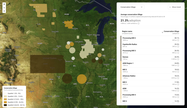
U.S. flag

An official website of the United States government

Landsat at Work: Transforming Data into Solutions

Landsat’s satellite imagery provides valuable data used by industries and decision makers in the field, ranging from energy and utilities to agriculture, insurance and more. Landsat’s archive reaches back more than 50 years, providing valuable insights into land, water and environmental conditions that shape planning, management, and response.

This collection of Landsat at Work stories highlights how that data is put into practice to inform decisions that help safeguard lives, property, and natural resources.


Keeping Wireless Signals Strong

Keeping Wireless Signals Strong

Preparing Residents Where Hurricanes Threaten

Preparing Residents Where Hurricanes Threaten

Reducing Fire Risk with Clear Utility Lines

Reducing Fire Risk with Clear Utility Lines

How Lithium Mining Observes Land Stewardship

How Lithium Mining Observes Land Stewardship

Measuring Water Use While Gaining Vineyard Yields

Measuring Water Use While Gaining Vineyard Yields

Respecting Habitats While Maintaining Utility Services

Respecting Habitats While Maintaining Utility Services

How Conservation Practices Preserve and Improve Soil Health

How Conservation Practices Preserve and Improve Soil Health

Monitoring Groundwater to Optimize Crop Production

Monitoring Groundwater to Optimize Crop Production


Was this page helpful?