
No matter the season, we are out monitoring Colorado waters.
In winter...
In winter...
No matter the season, we are out monitoring Colorado waters.
In spring...
In spring...
No matter the season, we are out monitoring Colorado waters.
In summer...
In summer...
No matter the season, we are out monitoring Colorado waters.
and in the fall.
and in the fall.
Colorado Water Science Center
Welcome to the USGS Colorado Water Science Center! Please use these pages to explore the hydrologic data and scientific investigations we conduct on Colorado water resources.
NOTICE: USGS is improving the way that sample data are stored and served to the public.
Current Conditions
Current Conditions
Explore real-time Colorado streamflow, groundwater, and water-quality conditions.
Science Highlight
Science Highlight

Next Generation Water Observing System: Upper Colorado River Basin
The Next Generation Water Observing System provides high-fidelity, real-time data on water quantity, quality, and use to support modern water prediction and decision-support systems that are necessary for informing water operations on a daily basis and decision-making during water emergencies.
News
2025 USGS 'STREAM' Workshop: Science, Technology, Research, and Evaluations for Actionable Management
2025 USGS 'STREAM' Workshop: Science, Technology, Research, and Evaluations for Actionable Management
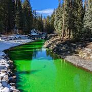
Media Alert: USGS Dye Tracing Study in Fraser River
Media Alert: USGS Dye Tracing Study in Fraser River
Media Alert: USGS Dye-Tracing Study in Lake Fork Creek to Map Groundwater Flow
Media Alert: USGS Dye-Tracing Study in Lake Fork Creek to Map Groundwater Flow
Publications
Peak-, mean-, and low-streamflow regional-regression equations for natural streamflow in central and western Colorado, 2019 Peak-, mean-, and low-streamflow regional-regression equations for natural streamflow in central and western Colorado, 2019
The U.S. Geological Survey (USGS), in cooperation with the Colorado Department of Transportation, developed peak-, mean-, and low-streamflow regional-regression equations for estimating various statistics for natural streamflow in hydrologic regions of central and western Colorado. The peak-streamflow regression equations were developed using data from 418 streamgages, consisting of 15...
A comparison of non-contact methods for measuring turbidity in the Colorado River A comparison of non-contact methods for measuring turbidity in the Colorado River
Monitoring suspended-sediment concentration (SSC) is essential to better understand how sediment transport could adversely affect water availability for human communities and ecosystems. Aquatic remote sensing methods are increasingly utilized to estimate SSC and turbidity in rivers; however, an evaluation of their quantitative performance is limited. This study evaluates the performance...
Groundwater-level elevations in the bedrock aquifers of the Denver Basin aquifer system, Elbert County, Colorado, 2015–23 Groundwater-level elevations in the bedrock aquifers of the Denver Basin aquifer system, Elbert County, Colorado, 2015–23
Water users in Elbert County, Colorado, rely on groundwater from bedrock aquifers in the Denver Basin aquifer system (upper Dawson, lower Dawson, Denver, Arapahoe, and Laramie-Fox Hills aquifers) for approximately half of their water uses. Withdrawals from the bedrocks aquifers have increased to meet the water use needs of expanding regional population growth and development. The U.S...
Science
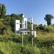
Next Generation Water Observing System (NGWOS) - Advancing Soil Moisture Monitoring
Soil moisture is an important part of the climate system, but it remains difficult to measure accurately. In 2022, the U.S. Geological Survey (USGS) began building a soil moisture monitoring network to provide high-quality continuous soil moisture data, standardize data collection methods, and test new technologies. Stations are placed in different climates and land cover types to capture a broad...
Quantifying groundwater recharge and discharge dynamics in the Upper Colorado River Basin
The Upper Colorado River Basin (UCOL) serves as an important source of water to millions of people, supports irrigation for agriculture, and provides aquatic habitat for a variety of species. Salinity concentrations endanger water supply in the Colorado River Basin, potentially causing hundreds of millions of dollars in annual economic damage because of corrosion of infrastructure, water treatment...
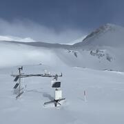
Next Generation Water Observing System (NGWOS) Snow Hydrology Monitoring Network in the Upper Colorado River Basin
Representative observations of snowpack conditions are vital for informing water availability assessments and modeling in snow dominated regions of the western United States. The U.S. Geological Survey (USGS) established a snow hydrology monitoring network in 2021 with the objective of providing high-quality, representative, and publicly available data on snowpack, soil moisture, and...