
Water data for Michigan, Minnesota, and Wisconsin
Access real-time and historical data for surface water, groundwater, water quality, and water use
Access real-time and historical data for surface water, groundwater, water quality, and water use
Edge-of-field monitoring
Testing the effectiveness of agricultural conservation practices for reducing nutrient and sediment runoff
Testing the effectiveness of agricultural conservation practices for reducing nutrient and sediment runoff
SPARROW models of streamflow and nitrogen, phosphorus, and suspended-s
SPARROW Watershed Models of Loads in Midwest Streams
SPARROW Watershed Models of Loads in Midwest Streams
Great Lakes urban stormwater monitoring
Assessing the ability of green infrastructure to reduce stormwater runoff in Great Lakes urban areas
Assessing the ability of green infrastructure to reduce stormwater runoff in Great Lakes urban areas
Great Lakes mercury sources revealed
Mercury "footprinting" identifies sources of pollution in the Great Lakes
Mercury "footprinting" identifies sources of pollution in the Great Lakes
Upper Midwest Water Science Center
Welcome to the Upper Midwest Water Science Center’s (UMid) Website. We offer information on streamflow, water quality, water-use, and groundwater data for Minnesota, Wisconsin and Michigan. We conduct unbiased, scientific hydrologic investigations and research projects to effectively manage the Upper Midwest's and our Nation's water resources through joint efforts with our partners.
Current conditions in MI, MN, and WI
Current conditions in MI, MN, and WI

Explore real-time streamflow, groundwater, and water-quality conditions and access data with our interactive map application.
Message from the Director
Message from the Director

Learn more about the Upper Midwest Water Science Center from Steve Peterson, our Center Director.
Upper Midwest Water Science Center Quick Links
Upper Midwest Water Science Center Quick Links
News
Summer 2026 Student Research Opportunities at the Upper Midwest Water Science Center
Summer 2026 Student Research Opportunities at the Upper Midwest Water Science Center
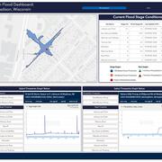
USGS Response to April 2026 Michigan and Wisconsin Floods
USGS Response to April 2026 Michigan and Wisconsin Floods
1,000 Cameras and Counting
1,000 Cameras and Counting
Publications
Assessment of groundwater quantity and quality contributions to Lake Huron Assessment of groundwater quantity and quality contributions to Lake Huron
Lake Huron, one of the five Great Lakes, borders the United States and Canada, with Michigan as the only U.S. State on its shoreline. Like other freshwater lakes, it faces water-quality challenges from nutrients and chemicals applied across its drainage basin. Although past studies focused on surface-water sources, groundwater contributions remain less understood. To address this gap...
Escherichia coli monitoring and assessment in 2022 and 2023 after beach restoration at Lake St. Clair Metropark Beach, Macomb County, Michigan Escherichia coli monitoring and assessment in 2022 and 2023 after beach restoration at Lake St. Clair Metropark Beach, Macomb County, Michigan
Lake St. Clair Metropark Beach in Michigan has a history of closures because of elevated Escherichia coli (E. coli) concentrations in its recreational waters. To reduce closures, restoration projects were implemented in 2021 to deter waterfowl from congregating on the beach. In this study, the U.S. Geological Survey, in cooperation with the Michigan Department of the Environment, Great...
Science
Low-Cost Sensor Networks for Pluvial Flash Flood Detection and Early Warning in Urban Areas
Flooding in urban areas is a serious weather-related threat to life and property. One type of flooding, called pluvial flooding, occurs during periods of intense rainfall where runoff overwhelms the capacity of soil to absorb it. In urban areas, pluvial flooding can be particularly dangerous because much of a city is covered by impervious surfaces such as streets, roofs, and parking lots forcing...
Oscillating Flows in the Milwaukee River Estuary
How do Lake Michigan water level variations and seiches affect the Milwaukee River estuary, its harbor, and rivers upstream?
Thermal Imagery to Inform Brook Trout Habitat Suitability and Restoration Potential, Upper Namekagon River, Wisconsin
The U.S. Geological Survey (USGS), in cooperation with the National Park Service (NPS), is using thermal infrared technology to identify cold-water habitat for brook trout and other cold-water species in the upper Namekagon River in Wisconsin. The upper Namekagon River and its tributaries have long served as a stronghold for brook trout and other cold- and cool-water species; however, changing...