
Water data for Michigan, Minnesota, and Wisconsin
Access real-time and historical data for surface water, groundwater, water quality, and water use
Access real-time and historical data for surface water, groundwater, water quality, and water use
Edge-of-field monitoring
Testing the effectiveness of agricultural conservation practices for reducing nutrient and sediment runoff
Testing the effectiveness of agricultural conservation practices for reducing nutrient and sediment runoff
SPARROW models of streamflow and nitrogen, phosphorus, and suspended-s
SPARROW Watershed Models of Loads in Midwest Streams
SPARROW Watershed Models of Loads in Midwest Streams
Great Lakes urban stormwater monitoring
Assessing the ability of green infrastructure to reduce stormwater runoff in Great Lakes urban areas
Assessing the ability of green infrastructure to reduce stormwater runoff in Great Lakes urban areas
Great Lakes mercury sources revealed
Mercury "footprinting" identifies sources of pollution in the Great Lakes
Mercury "footprinting" identifies sources of pollution in the Great Lakes
Upper Midwest Water Science Center
Welcome to the Upper Midwest Water Science Center’s (UMid) Website. We offer information on streamflow, water quality, water-use, and groundwater data for Minnesota, Wisconsin and Michigan. We conduct unbiased, scientific hydrologic investigations and research projects to effectively manage the Upper Midwest's and our Nation's water resources through joint efforts with our partners.
Current conditions in MI, MN, and WI
Current conditions in MI, MN, and WI

Explore real-time streamflow, groundwater, and water-quality conditions and access data with our interactive map application.
Message from the Director
Message from the Director

Learn more about the Upper Midwest Water Science Center from Steve Peterson, our Center Director.
Upper Midwest Water Science Center Quick Links
Upper Midwest Water Science Center Quick Links
News
Media Alert: Low-level helicopter flights to image geology of Lake Superior Basin
Media Alert: Low-level helicopter flights to image geology of Lake Superior Basin
Summer 2026 Student Research Opportunities at the Upper Midwest Water Science Center
Summer 2026 Student Research Opportunities at the Upper Midwest Water Science Center
Upper Midwest Water Science Center Great Waters Newsletter: Spring 2026
Upper Midwest Water Science Center Great Waters Newsletter: Spring 2026
Publications
Mercury mobilization and export from the Greenland Ice Sheet using an ice-to-ocean approach Mercury mobilization and export from the Greenland Ice Sheet using an ice-to-ocean approach
The Greenland Ice Sheet (GrIS) is a poorly constrained source of mercury (Hg) to Arctic ecosystems. We measured Hg concentrations and stable isotopes along an ice-to-ocean continuum to identify controls on GrIS Hg export. Early-season permafrost melt and rainfall produced high filtered total mercury (fTHg, ~17 pM) and monomethylmercury (MMHg, ~2 pM). As subglacial drainage evolved...
The electric vehicle “EV”-crane—A next-generation system for fluvial sediment and water-quality sampling using an electric cart with integrated crane and accessories The electric vehicle “EV”-crane—A next-generation system for fluvial sediment and water-quality sampling using an electric cart with integrated crane and accessories
The U.S. Geological Survey (USGS), with support from the Federal Interagency Sedimentation Project (FISP), developed the electric vehicle (EV)-crane, a modified electric cart equipped with a rigid swivel-mounted crane and integrated accessory holders. The EV-crane was developed to improve the efficiency and safety of fluvial sediment and water-quality sampling from bridges. USGS field...
The US XPD-24–200—An isokinetic suspended-sediment and water-quality collapsible-bag sampler with point- or depth-integrating sampling capabilities The US XPD-24–200—An isokinetic suspended-sediment and water-quality collapsible-bag sampler with point- or depth-integrating sampling capabilities
Accurate collection of fluvial suspended‑sediment and water‑quality samples is essential for understanding transport processes, evaluating river health, quantifying loads, and supporting regulatory and management decisions. Since 1939, the Federal Interagency Sedimentation Project (FISP) has led the development and standardization of sediment‑sampling equipment and methods across Federal...
Science

SPARROW modeling: Estimating nutrient, sediment, and dissolved solids transport
SPARROW (SPAtially Referenced Regression On Watershed attributes) models estimate the amount of a contaminant transported from inland watersheds to larger water bodies by linking monitoring data with information on watershed characteristics and contaminant sources. Interactive, online SPARROW mapping tools allow for easy access to explore relations between human activities, natural processes, and...
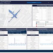
Low-Cost Sensor Networks for Pluvial Flash Flood Detection and Early Warning in Urban Areas
Flooding in urban areas is a serious weather-related threat to life and property. One type of flooding, called pluvial flooding, occurs during periods of intense rainfall where runoff overwhelms the capacity of soil to absorb it. In urban areas, pluvial flooding can be particularly dangerous because much of a city is covered by impervious surfaces such as streets, roofs, and parking lots forcing...

Oscillating Flows in the Milwaukee River Estuary
How do Lake Michigan water level variations and seiches affect the Milwaukee River estuary, its harbor, and rivers upstream?