
About
The vision for Core Science Systems builds on core strengths of the USGS in characterizing and understanding complex Earth and biological systems through research, modeling, mapping, and the production of high quality data on the Nation’s natural resource infrastructure.

Pecora Pecora
The Pecora Award and Pecora Conference highlight advances in remote sensing and recognize contributions that support the use of Earth observation. Together, they reflect the ongoing importance of collaboration, innovation, and long-term commitment to understanding our planet.
Operations Operations
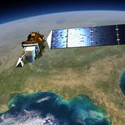
The U.S. Geological Survey’s National Land Imaging Program manages a range of operational activities that ensure the consistent acquisition, delivery, and application of Earth observation data. These efforts support Landsat satellite operations, coordinate remote sensing capabilities across federal and international partners, and provide rapid access to imagery during disasters and emergencies.
100K OnDemand Topo Cartographic Specifications 100K OnDemand Topo Cartographic Specifications
This page and associated links define the U.S. Geological Survey (USGS) 100K OnDemand Topo cartographic specifications including feature symbology and labels. The specifications are organized by data sets and themes listed within.
Data Discovery Data Discovery
The USGS National Remote Sensing Data Archive provides foundational imagery and geospatial data for the Nation. EROS science products offer insights into land cover, fire, hazards, and elevation change. The Land Processes Distributed Active Archive Center (LP DAAC), a USGS–NASA partnership, distributes NASA satellite data in support of land and water research.

What is 3DEP? What is 3DEP?
The 3D Elevation Program (3DEP) informs critical decisions that are made across our Nation every day that depend on 3D data, ranging from immediate safety of life, property, and environment to long term planning for infrastructure projects.

National Science Foundation - Ice Core Facility National Science Foundation - Ice Core Facility
The National Science Foundation Ice Core Facility (NSF-ICF) is located at the Denver Federal Center in Colorado. The Facility is managed and operated by the U.S. Geological Survey for the National Science Foundation.

Kevin Gallagher Kevin Gallagher
The U.S. Geological Survey (USGS) Core Science Systems (CSS) Mission Area builds on the core strengths of the USGS in characterizing and understanding complex Earth and biological systems through research, modeling, mapping, and the production of high-quality data. CSS delivers natural science information to the Nation in support of smart decisionmaking.

History History
The United States Geological Survey was established on March 3, 1879, just a few hours before the mandatory close of the final session of the 45th Congress, when President Rutherford B. Hayes signed the bill appropriating money for sundry civil expenses of the Federal Government for the fiscal year beginning July 1, 1879.
What We Do What We Do
The Core Science Systems Mission Area delivers nationally focused Earth systems and information science that provides fundamental research and data that underpins all Mission Areas of the USGS, the USGS Science Strategy, and Presidential, Secretarial, and societal priorities.

Director's Message Director's Message
The U.S. Geological Survey (USGS) Core Science Systems (CSS) Mission Area builds on the core strengths of the USGS in characterizing and understanding complex Earth and biological systems through research, modeling, mapping, and the production of high-quality data. CSS delivers natural science information to the Nation in support of smart decisionmaking.