
This graphic displays the number of Landsat Collection 2 Level-2 scene-based science products that are available for download from the USGS Archive. Level-2 science products were first introduced with the Collection 2 release in December, 2020. The Level-2 Science Product includes surface reflection and surface temperature data.
Multimedia
Our multimedia gallery represents a collection of high-quality images, videos, webcams, posters, presentations, and documents produced by Core Science Systems.
Images
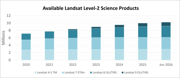
Available Landsat Level-2 Science Products
This graphic displays the number of Landsat Collection 2 Level-2 scene-based science products that are available for download from the USGS Archive. Level-2 science products were first introduced with the Collection 2 release in December, 2020. The Level-2 Science Product includes surface reflection and surface temperature data.
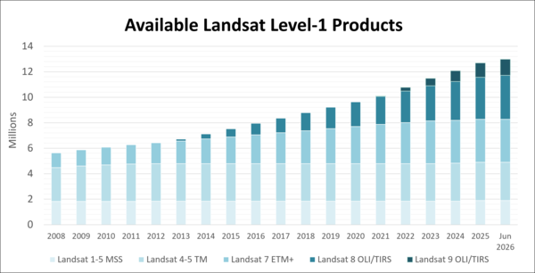
Available Landsat Level-1 Products
This graph shows the number of Landsat Collection 2 Level-1 scene-based products that are available for download from the USGS Archive. Please note that data from earlier Landsat missions, even those that have ended, continues to be added to the archive through the Landsat Global Archive Consolidation (LGAC) program.
This graph shows the number of Landsat Collection 2 Level-1 scene-based products that are available for download from the USGS Archive. Please note that data from earlier Landsat missions, even those that have ended, continues to be added to the archive through the Landsat Global Archive Consolidation (LGAC) program.
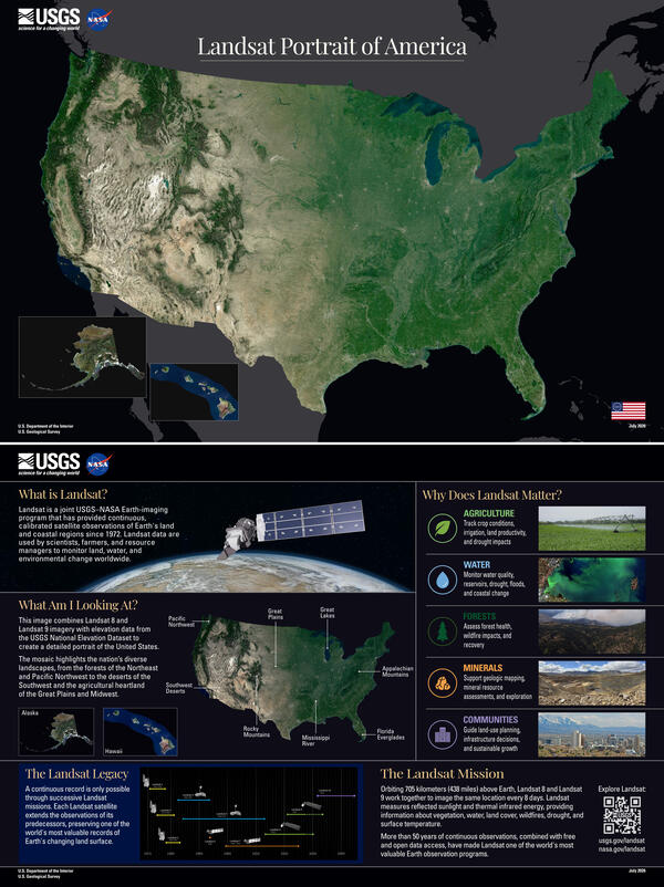
Landsat Portrait of America
The complete Landsat Portrait of America poster, shown with the front on top and the back below.
The complete Landsat Portrait of America poster, shown with the front on top and the back below.
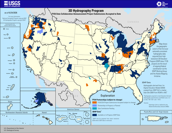
3D Hydrography Program FY26 DCA Project Submissions Accepted to Date
3D Hydrography Program FY26 DCA Project Submissions Accepted to DateThis map of the United States and its territories shows geographic extent of the first-ever nationally consistent hydrography data acquired from high-resolution 3D Elevation Program (3DEP) data. FY26 projects are the result of ongoing Federal coordination via the 3DHP Working Group and the Alaska Mapping Initiative.
Sources/Usage
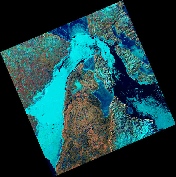
Ice Fills Roes Welcome Sound
The Landsat 8 satellite captured an image showing sea ice packed into Roes Welcome Sound, located along the northwestern edge of Southampton Island and around Qikiqtaaluk Island in the uninhabited Canadian Arctic Archipelago. East of Qikiqtaaluk, ice drifts through the Frozen Strait, extending eastward into Foxe Basin.
The Landsat 8 satellite captured an image showing sea ice packed into Roes Welcome Sound, located along the northwestern edge of Southampton Island and around Qikiqtaaluk Island in the uninhabited Canadian Arctic Archipelago. East of Qikiqtaaluk, ice drifts through the Frozen Strait, extending eastward into Foxe Basin.
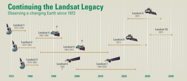
Continuing the Landsat Legacy
Timeline of the Landsat program, beginning with the launch of Landsat 1 in 1972. Landsat 10 is expected to launch in 2031. As the tenth Landsat mission, it will continue the legacy of the Landsat program.
Visit the Landsat Missions webpage to learn more.
Timeline of the Landsat program, beginning with the launch of Landsat 1 in 1972. Landsat 10 is expected to launch in 2031. As the tenth Landsat mission, it will continue the legacy of the Landsat program.
Visit the Landsat Missions webpage to learn more.
Videos
 Tool Demo")
MRLC Enhanced Visualization and Analysis (EVA) Tool Demo
MRLC Enhanced Visualization and Analysis (EVA) Tool DemoThis video is a demonstration of the EVA Tool. It was conducted during the January 20, 2026 webinar. To watch the full webinar please visit: https://www.usgs.gov/media/videos/visualizing-land-cover-mrlc-tools.

National Tribal Webinar on the USGS 3D Elevation Program and 3D Hydrography Program
National Tribal Webinar on the USGS 3D Elevation Program and 3D Hydrography ProgramThis video summarizes the 3DEP and 3DHP programs for a Tribal audience, providing an overview of the program and its goals and methods. The presentation includes information about topics of possible concern to Tribes, and points of contact to address questions and concerns.

JACIE: Joint Agency Commercial Imagery Evaluation
The Joint Agency Commercial Imagery Evaluation, better known as JACIE, was created to bring together the strengths of multiple Federal agencies.
Its mission is simple, yet essential, to evaluate remote sensing data, and share those insights with the entire remote sensing community.
The Joint Agency Commercial Imagery Evaluation, better known as JACIE, was created to bring together the strengths of multiple Federal agencies.
Its mission is simple, yet essential, to evaluate remote sensing data, and share those insights with the entire remote sensing community.

April 2026 USGS Hydrography Community Call
The call will cover USGS Hydrography Program information:
The call will cover USGS Hydrography Program information:

Landsat Special Requests: Expanding Acquisition Capabilities
Landsat Special Requests: Expanding Acquisition CapabilitiesThis video is a recording of a previous webinar entitled: “Landsat Special Requests: Expanding Acquisition Capabilities”. This webinar was recorded on April 16, 2026.
Landsat Special Requests: Expanding Acquisition Capabilities
Landsat Special Requests: Expanding Acquisition CapabilitiesThis video is a recording of a previous webinar entitled: “Landsat Special Requests: Expanding Acquisition Capabilities”. This webinar was recorded on April 16, 2026.

Introducing ASTER Version 4: What's New in Data Access, Products, Formats, and How to Unlock the ASTER Cloud Archive
Introducing ASTER Version 4: What's New in Data Access, Products, Formats, and How to Unlock the ASTER Cloud ArchiveThis video is a recording of a previous webinar entitled: “Introducing ASTER Version 4: What’s New in Data Access, Products, Formats, and How to Unlock the ASTER Cloud Archive”. This webinar was recorded on April 2, 2026.
Audio
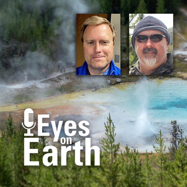
Eyes on Earth Episode 137 – Landsat Takes Yellowstone’s Temperature
Eyes on Earth Episode 137 – Landsat Takes Yellowstone’s TemperatureThe Yellowstone National Park area has more than 10,000 thermal features. And while Old Faithful is a pretty predictable geyser, some thermal features can change quite a bit. New ones can even pop up! Remote sensing provides a tool for monitoring them—especially the thermal infrared sensors (TIRS) on Landsat 8 and Landsat 9 satellites.
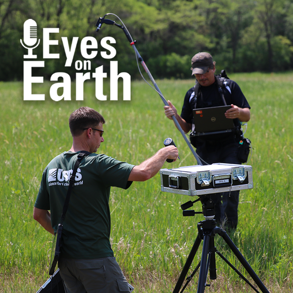
Eyes on Earth Episode 136 – The EROS Test Site
Landsat has been accurate and reliable for over 50 years because of the diligent calibration and validation work done by the team at EROS. One of the ways the team validates what they have so carefully calibrated is to take measurements on the ground while Landsat passes by overhead.
Landsat has been accurate and reliable for over 50 years because of the diligent calibration and validation work done by the team at EROS. One of the ways the team validates what they have so carefully calibrated is to take measurements on the ground while Landsat passes by overhead.

Eyes on Earth Episode 135 – Exotic Annual Grasses and Sheep Grazing
Eyes on Earth Episode 135 – Exotic Annual Grasses and Sheep GrazingExotic annual grasses, or EAGs, are invasive species. They outcompete native grasses. They are extremely flammable. And they are expanding into higher elevations. Targeted sheep grazing is one way to combat these invasive grasses, manage fire risk, and help restore native sagebrush in western states.

Eyes on Earth Episode 134 – Data Accuracy: The Calibration and Validation of Landsat
Eyes on Earth Episode 134 – Data Accuracy: The Calibration and Validation of LandsatLandsat is the longest-running, continuously operating record of Earth observations, and it’s the gold standard reference point that other civil and commercial satellite programs trust.

Eyes on Earth Episode 133 – Vietnam War Bomb Craters
Eyes on Earth Episode 133 – Vietnam War Bomb CratersDeclassified spy satellite imagery, distributed by the USGS EROS Center, is finding fascinating uses since being made available to the public starting in the 1990s.
Eyes on Earth Episode 133 – Vietnam War Bomb Craters
Eyes on Earth Episode 133 – Vietnam War Bomb CratersDeclassified spy satellite imagery, distributed by the USGS EROS Center, is finding fascinating uses since being made available to the public starting in the 1990s.

Eyes on Earth Episode 132 - Moving Forward with AI at EROS
Eyes on Earth Episode 132 - Moving Forward with AI at EROSEyes on Earth tackles artificial intelligence (AI) in a 2-part episode. AI is quickly becoming a necessary part of geospatial work at EROS, helping us efficiently do science to better manage our world. In Part 1, we talked about AI’s current and upcoming impact on our work at EROS and clarified some of the AI jargon.