U.S. flag

An official website of the United States government

Multimedia

Explore this collection of photos, maps, infographics and videos related to USGS energy and mineral research. 

Images

A white aircraft descends with landing gear extended set against a backdrop of blue sky, scattered clouds, and mountains
NASA’s ER‑2 high‑altitude research aircraft touches down in Colorado Springs May 11, 2026

NASA’s ER‑2 high‑altitude research aircraft touches down in Colorado Springs May 11, 2026, after completing a hyperspectral survey flight for the joint USGS–NASA effort to map critical minerals across the western United States.

Two people in a hangar at a workstation displaying hyperspectral survey maps, surrounded by laptops and field equipment
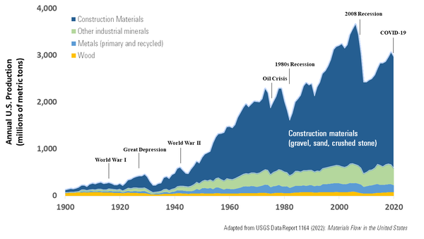
Monitoring hyperspectral data while NASA’s high‑altitude ER‑2 aircraft conducts mineral‑mapping flights

U.S. Geological Survey geophysicists Ray Kokaly (left) and Todd Hoefen (right) monitor incoming hyperspectral data in the hangar as NASA’s high‑altitude ER‑2 aircraft conducts mineral‑mapping flights over the western United States.

Infographic flowchart demonstrating the USGS methodology for recommending minerals for the List of Critical Minerals
2025 List of Critical Minerals Methodology Infographic

Infographic flowchart summarizing the USGS methodology for technical input to the 2025 List of Critical Minerals. The full methodology is found here: Methodology and technical input for the 2025 U.S.

Map showing drought conditions in the National Weather Service Colorado River Basin River Forecast Area, April 7, 2026
U.S. Drought Monitor Drought Conditions Map, National Weather Service Colorado River Basin Forecast Center, April 7, 2026

Image for the USGS Colorado River Basin Actionable and Strategic Integrated Science and Technology (ASIST) Initiative, geonarrative about the intersection of water use for copper mining and historic drought in the Lower Colorado River Basin (primarily Arizona), April 7, 2026.

Grey background map of the US and Canada focused on the region around the Great Lakes with geologic map overlay in a variety
Surficial Geology of the Glaciated Region of the US

This is a partial representation of a geologic map of the Surficial geology of the glaciated region of the US. The blue dashed lines represent glacial and glaciofluvial features, roughly outlining the boundary of the glaciated region. The black outlined states represent the eight member states of the Great Lakes Geologic Mapping Coalition. 

This is a partial representation of a geologic map of the Surficial geology of the glaciated region of the US. The blue dashed lines represent glacial and glaciofluvial features, roughly outlining the boundary of the glaciated region. The black outlined states represent the eight member states of the Great Lakes Geologic Mapping Coalition. 

Videos

Thumbnail for video about Earth MRI in the West Thumbnail for video about Earth MRI in the West
Earth MRI: Revealing critical resources across the western United States

The USGS Earth Mapping Resources Initiative (Earth MRI) is accelerating modern geological and geophysical mapping across the Western United States and the nation.

AD Thumbnail for video about Earth MRI in the East AD Thumbnail for video about Earth MRI in the East
Earth MRI: A journey beneath the east coast (AD)

The USGS Earth Mapping Resources Initiative (Earth MRI) is accelerating modern geological and geophysical mapping across the Eastern United States and the nation. 

AD Thumbnail for video about Earth MRI in the West AD Thumbnail for video about Earth MRI in the West
Earth MRI: Revealing critical resources across the western United States (AD)
Thumbnail for video about Earth MRI in the East Thumbnail for video about Earth MRI in the East
Earth MRI: A journey beneath the east coast

The USGS Earth Mapping Resources Initiative (Earth MRI) is accelerating modern geological and geophysical mapping across the Eastern United States and the nation. 

The USGS Earth Mapping Resources Initiative (Earth MRI) is accelerating modern geological and geophysical mapping across the Eastern United States and the nation. 

Was this page helpful?