(Right) Spattering at the edge of the pond during the fall cycle.
(Right) Spattering at the edge of the pond during the fall cycle.(Right) Spattering at the edge of the pond during the fall cycle.

Official websites use .gov
A .gov website belongs to an official government organization in the United States.
Secure .gov websites use HTTPS
A lock () or https:// means you’ve safely connected to the .gov website. Share sensitive information only on official, secure websites.
Images related to natural hazards.

(Right) Spattering at the edge of the pond during the fall cycle.
(Right) Spattering at the edge of the pond during the fall cycle.

Mar 21, 2014: The lava lake at the summit of Kīlauea Volcano remains active. During our observation today, the lava lake surface was about 40 m (131 ft) below the rim of the vent (the Overlook crater) within Halema‘uma‘u Crater.
Mar 21, 2014: The lava lake at the summit of Kīlauea Volcano remains active. During our observation today, the lava lake surface was about 40 m (131 ft) below the rim of the vent (the Overlook crater) within Halema‘uma‘u Crater.

Mar 21, 2014: The small (10 meters, or 30 feet, wide) lava pond within the northeast spatter cone on Pu‘u ‘Ō‘ō experiences cyclic rises and falls of the lava surface called "gas pistoning," driven by the buildup and release of gas in the pond. At the time of this photograph, the pond surface had dropped following the release of gas.
Mar 21, 2014: The small (10 meters, or 30 feet, wide) lava pond within the northeast spatter cone on Pu‘u ‘Ō‘ō experiences cyclic rises and falls of the lava surface called "gas pistoning," driven by the buildup and release of gas in the pond. At the time of this photograph, the pond surface had dropped following the release of gas.

Mar 21, 2014: The release of gas from the lava pond at Pu‘u ‘Ō‘ō nearly obscures the spatter (fluid fragments of molten lava) being thrown about a meter (3 ft) high.
Mar 21, 2014: The release of gas from the lava pond at Pu‘u ‘Ō‘ō nearly obscures the spatter (fluid fragments of molten lava) being thrown about a meter (3 ft) high.

Mar 21, 2014: (Left) The lava pond surface at its highest level observed during our field work today—just before the release of gas caused it to drop during the fall cycle of the gas pistoning.
Mar 21, 2014: (Left) The lava pond surface at its highest level observed during our field work today—just before the release of gas caused it to drop during the fall cycle of the gas pistoning.
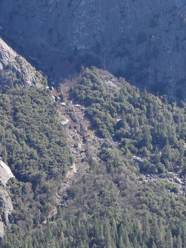
In this image, a landslide may be seen in detail below Moran Point in Yosemite Valley. The broken rock fragments are often referred to as talus deposits or scree.
In this image, a landslide may be seen in detail below Moran Point in Yosemite Valley. The broken rock fragments are often referred to as talus deposits or scree.
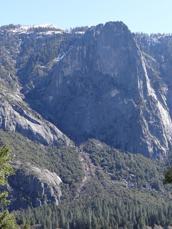
In this image, a landslide may be seen below Moran Point in Yosemite Valley. The broken rock fragments are often referred to as talus deposits or scree.
In this image, a landslide may be seen below Moran Point in Yosemite Valley. The broken rock fragments are often referred to as talus deposits or scree.

Mar 7, 2014: Another view of the active flow front, which is burning forest and causing scattered fires. Mauna Loa (left) and Mauna Kea (right, with a snow-covered summit) are on the skyline in this wide photograph. At the very left edge of the photo, the plume from Kīlauea's summit lava lake can be seen.
Mar 7, 2014: Another view of the active flow front, which is burning forest and causing scattered fires. Mauna Loa (left) and Mauna Kea (right, with a snow-covered summit) are on the skyline in this wide photograph. At the very left edge of the photo, the plume from Kīlauea's summit lava lake can be seen.

Mar 7, 2014: A close-up of the lava pond in Pu‘u ‘Ō‘ō crater, with snow-covered Mauna Kea in the distance.
Mar 7, 2014: A close-up of the lava pond in Pu‘u ‘Ō‘ō crater, with snow-covered Mauna Kea in the distance.

Mar 7, 2014: The lava lake in the Overlook crater, within Halema‘uma‘u Crater, at Kīlauea's summit remains active. Today, winds carried the plume towards the north, providing a clear view of the persistent spattering area in the southeast portion of the lake.
Mar 7, 2014: The lava lake in the Overlook crater, within Halema‘uma‘u Crater, at Kīlauea's summit remains active. Today, winds carried the plume towards the north, providing a clear view of the persistent spattering area in the southeast portion of the lake.

Mar 7, 2014: The Kahauale‘a 2 flow remains active, and the active flow front is moving through thick forest northeast of Pu‘u ‘Ō‘ō. The flow front today was 7.9 km (4.9 miles) northeast of the vent on Pu‘u ‘Ō‘ō. Pu‘u ‘Ō‘ō is visible in the upper left of the photograph, and is partly obscured by fume.
Mar 7, 2014: The Kahauale‘a 2 flow remains active, and the active flow front is moving through thick forest northeast of Pu‘u ‘Ō‘ō. The flow front today was 7.9 km (4.9 miles) northeast of the vent on Pu‘u ‘Ō‘ō. Pu‘u ‘Ō‘ō is visible in the upper left of the photograph, and is partly obscured by fume.

Mar 7, 2014: The northeast spatter cone has had a small (10 meters, or 30 feet, wide) lava pond, which experiences a cyclic rise and fall of the lava surface called "gas pistoning", driven by the buildup and release of gas in the pond. This photograph captured the moment of gas release, which involved vigorous spattering.
Mar 7, 2014: The northeast spatter cone has had a small (10 meters, or 30 feet, wide) lava pond, which experiences a cyclic rise and fall of the lava surface called "gas pistoning", driven by the buildup and release of gas in the pond. This photograph captured the moment of gas release, which involved vigorous spattering.

Mar 7, 2014: View of Pu‘u ‘Ō‘ō from the south. Pu‘u ‘Ō‘ō's tan-colored south flank is composed of cinder and spatter erupted in its early years (mid-1980s). Since that time, the cone has partially collapsed and lava flows have erupted on the flanks and within the crater, sometimes spilling over the crater rim.
Mar 7, 2014: View of Pu‘u ‘Ō‘ō from the south. Pu‘u ‘Ō‘ō's tan-colored south flank is composed of cinder and spatter erupted in its early years (mid-1980s). Since that time, the cone has partially collapsed and lava flows have erupted on the flanks and within the crater, sometimes spilling over the crater rim.

Large swells from the north-northeast with heights up to 5 meters (16 feet) combined with unusually high tides inundated much of the Republic of the Marshall Islands on March 2, 2014.
Large swells from the north-northeast with heights up to 5 meters (16 feet) combined with unusually high tides inundated much of the Republic of the Marshall Islands on March 2, 2014.

Wave-driven flooding and overwash on Roi-Namur Atoll, Republic of the Marshall Islands
Wave-driven flooding and overwash on Roi-Namur Atoll, Republic of the Marshall Islands

Mauve indicates areas at risk from lava flows and avalanches of hot rock and gases called pyroclastic flows. Bright red areas that fade to orange and yellow indicate potential routes for lahars (volcanic mudflows). Not shown are areas subject to hazards from volcanic ash.
Mauve indicates areas at risk from lava flows and avalanches of hot rock and gases called pyroclastic flows. Bright red areas that fade to orange and yellow indicate potential routes for lahars (volcanic mudflows). Not shown are areas subject to hazards from volcanic ash.

Newberry Volcano, Oregon simplified hazards map showing potential impact area for ground-based hazards during a volcanic event.
Newberry Volcano, Oregon simplified hazards map showing potential impact area for ground-based hazards during a volcanic event.

Mount Adams, Washington simplified hazards map showing potential impact area for ground-based hazards during a volcanic event.
Mount Adams, Washington simplified hazards map showing potential impact area for ground-based hazards during a volcanic event.

Three Sisters, Oregon simplified hazards map showing potential impact area for ground-based hazards during a volcanic event.
Three Sisters, Oregon simplified hazards map showing potential impact area for ground-based hazards during a volcanic event.

Wave-driven flooding and overwash on Roi-Namur Atoll, Republic of the Marshall Islands
Wave-driven flooding and overwash on Roi-Namur Atoll, Republic of the Marshall Islands

This map shows areas that could be affected by debris flows, lahars, lava flows, and pyroclastic flows from Mount Rainier if events similar in size to past events occurred today. Because small lahars are more common than large ones, most lahars would be less extensive than the hazard zone shown on the map and a few would be more extensive.
This map shows areas that could be affected by debris flows, lahars, lava flows, and pyroclastic flows from Mount Rainier if events similar in size to past events occurred today. Because small lahars are more common than large ones, most lahars would be less extensive than the hazard zone shown on the map and a few would be more extensive.