



USGS scientists were deployed to assess land deformation and movement after a large M6.4 earthquake struck Puerto Rico on January 7, 2020. The boardwalk in Ponce, Puerto Rico was damaged by the quake.
Images
Images related to natural hazards.
Filter Total Items: 7275

Inspecting boardwalk in Ponce, Puerto Rico
USGS scientists were deployed to assess land deformation and movement after a large M6.4 earthquake struck Puerto Rico on January 7, 2020. The boardwalk in Ponce, Puerto Rico was damaged by the quake.

Inspecting boardwalk in Ponce, Puerto Rico
USGS scientists were deployed to assess land deformation and movement after a large M6.4 earthquake struck Puerto Rico on January 7, 2020. The boardwalk in Ponce, Puerto Rico was damaged by the quake.
USGS scientists were deployed to assess land deformation and movement after a large M6.4 earthquake struck Puerto Rico on January 7, 2020. The boardwalk in Ponce, Puerto Rico was damaged by the quake.

Inspecting boardwalk in Ponce, Puerto Rico
USGS scientists were deployed to assess land deformation and movement after a large M6.4 earthquake struck Puerto Rico on January 7, 2020. The boardwalk in Ponce, Puerto Rico was damaged by the quake.
USGS scientists were deployed to assess land deformation and movement after a large M6.4 earthquake struck Puerto Rico on January 7, 2020. The boardwalk in Ponce, Puerto Rico was damaged by the quake.

Coastal storm modeling system integrates economic impacts
Coastal storm modeling system integrates economic impactsPatrick Barnard explains how the Coastal Storm Modeling System (CoSMoS) integrates information from the Hazards Exposure Reporting and Analytics (HERA) mapper to understand the social and economic consequences of different flooding scenarios.
Coastal storm modeling system integrates economic impacts
Coastal storm modeling system integrates economic impactsPatrick Barnard explains how the Coastal Storm Modeling System (CoSMoS) integrates information from the Hazards Exposure Reporting and Analytics (HERA) mapper to understand the social and economic consequences of different flooding scenarios.

House marking in Puerto Rico
Houses were damaged during the M6.4 earthquake that struck Puerto Rico on January 7, 2020. Houses were tagged by local officials for whether they were safe or not.
Houses were damaged during the M6.4 earthquake that struck Puerto Rico on January 7, 2020. Houses were tagged by local officials for whether they were safe or not.

Inspecting boardwalk in Ponce, Puerto Rico
USGS scientists were deployed to assess land deformation and movement after a large M6.4 earthquake struck Puerto Rico on January 7, 2020. The boardwalk in Ponce, Puerto Rico was damaged by the quake.
USGS scientists were deployed to assess land deformation and movement after a large M6.4 earthquake struck Puerto Rico on January 7, 2020. The boardwalk in Ponce, Puerto Rico was damaged by the quake.

Water pond in Halema‘uma‘u continues to grow
Comparison of the water pond in Halema‘uma‘u on November 20, 2019, and March 1, 2020. Camera and lens same for both photos. Since November 20, 2019, the pond deepened 10 m (33 ft) and widened more than 50 m (164 ft) east-west and 30 m (98 ft) north-south. Circled clusters of rocks did not move between photos, evidence of slope stability.
Comparison of the water pond in Halema‘uma‘u on November 20, 2019, and March 1, 2020. Camera and lens same for both photos. Since November 20, 2019, the pond deepened 10 m (33 ft) and widened more than 50 m (164 ft) east-west and 30 m (98 ft) north-south. Circled clusters of rocks did not move between photos, evidence of slope stability.

Landslide triggered by M6.4 earthquake in Puerto Rico
Landslide triggered by M6.4 earthquake in Puerto RicoUSGS scientists were deployed to assess land deformation and movement after a large M6.4 earthquake struck Puerto Rico on January 7, 2020. Here is an example of a landslide failure along a residential road in Ponce, Puerto Rico.
Landslide triggered by M6.4 earthquake in Puerto Rico
Landslide triggered by M6.4 earthquake in Puerto RicoUSGS scientists were deployed to assess land deformation and movement after a large M6.4 earthquake struck Puerto Rico on January 7, 2020. Here is an example of a landslide failure along a residential road in Ponce, Puerto Rico.

Landslide along road near Ponce, Puerto Rico
USGS scientists were deployed to assess land deformation and movement after a large M6.4 earthquake struck Puerto Rico on January 7, 2020. This landslide was discovered along a neighborhood road near Ponce, Puerto Rico.
USGS scientists were deployed to assess land deformation and movement after a large M6.4 earthquake struck Puerto Rico on January 7, 2020. This landslide was discovered along a neighborhood road near Ponce, Puerto Rico.

2020 Puerto Rico Earthquake Sequence (as of Jan. 16, 2020)
2020 Puerto Rico Earthquake Sequence (as of Jan. 16, 2020)Earthquakes detected between December 28, 2019 as of January 16, 2020. Subject to updates.
>300 M3+earthquakes recorded*
since Dec. 28, 2019 (within 40km) strong enough to be felt
10 M5+ earthquakes recorded*
since Dec. 28, 2019 (including M6.4) large enough to do damage
2020 Puerto Rico Earthquake Sequence (as of Jan. 16, 2020)
2020 Puerto Rico Earthquake Sequence (as of Jan. 16, 2020)Earthquakes detected between December 28, 2019 as of January 16, 2020. Subject to updates.
>300 M3+earthquakes recorded*
since Dec. 28, 2019 (within 40km) strong enough to be felt
10 M5+ earthquakes recorded*
since Dec. 28, 2019 (including M6.4) large enough to do damage

Lateral spread along road caused by M6.4 earthquake in Puerto Rico
Lateral spread along road caused by M6.4 earthquake in Puerto RicoUSGS scientists were deployed to assess land deformation and movement after a large M6.4 earthquake struck Puerto Rico on January 7, 2020. Here is an example of a lateral spread along a residential road in Ponce, Puerto Rico.
Lateral spread along road caused by M6.4 earthquake in Puerto Rico
Lateral spread along road caused by M6.4 earthquake in Puerto RicoUSGS scientists were deployed to assess land deformation and movement after a large M6.4 earthquake struck Puerto Rico on January 7, 2020. Here is an example of a lateral spread along a residential road in Ponce, Puerto Rico.

House marking in Puerto Rico
Houses were damaged during the M6.4 earthquake that struck Puerto Rico on January 7, 2020. Houses were tagged by local officials for whether they were safe or not.
Houses were damaged during the M6.4 earthquake that struck Puerto Rico on January 7, 2020. Houses were tagged by local officials for whether they were safe or not.

Lateral Spread in Ponce, Puerto Rico
USGS scientists were deployed to assess land deformation and movement after a large M6.4 earthquake struck Puerto Rico on January 7, 2020. Here is an example of a lateral spread near a stream in Ponce, Puerto Rico.
USGS scientists were deployed to assess land deformation and movement after a large M6.4 earthquake struck Puerto Rico on January 7, 2020. Here is an example of a lateral spread near a stream in Ponce, Puerto Rico.

Inspecting boardwalk in Ponce, Puerto Rico
USGS scientists were deployed to assess land deformation and movement after a large M6.4 earthquake struck Puerto Rico on January 7, 2020. The boardwalk in Ponce, Puerto Rico was damaged by the quake.
USGS scientists were deployed to assess land deformation and movement after a large M6.4 earthquake struck Puerto Rico on January 7, 2020. The boardwalk in Ponce, Puerto Rico was damaged by the quake.

Inspecting boardwalk in Ponce, Puerto Rico
USGS scientists were deployed to assess land deformation and movement after a large M6.4 earthquake struck Puerto Rico on January 7, 2020. The boardwalk in Ponce, Puerto Rico was damaged by the quake.
USGS scientists were deployed to assess land deformation and movement after a large M6.4 earthquake struck Puerto Rico on January 7, 2020. The boardwalk in Ponce, Puerto Rico was damaged by the quake.

Researchers deployed in Puerto Rico after earthquake
Researchers deployed in Puerto Rico after earthquakeMeet the team of USGS scientists who were deployed to assess land deformation and movement after a large M6.4 earthquake struck Puerto Rico on January 7, 2020.
Researchers deployed in Puerto Rico after earthquake
Researchers deployed in Puerto Rico after earthquakeMeet the team of USGS scientists who were deployed to assess land deformation and movement after a large M6.4 earthquake struck Puerto Rico on January 7, 2020.

USGS Earthquake Response team with governor of Puerto Rico
USGS Earthquake Response team with governor of Puerto RicoUSGS team with Wanda Vazquez-Garced, governor of Puerto Rico. From left to right: Lindsay Davis, Wanda Vazquez, Dianne Lopez-Trujillo, Jonathan Godt, Donyelle Davis, Alex Grant
USGS Earthquake Response team with governor of Puerto Rico
USGS Earthquake Response team with governor of Puerto RicoUSGS team with Wanda Vazquez-Garced, governor of Puerto Rico. From left to right: Lindsay Davis, Wanda Vazquez, Dianne Lopez-Trujillo, Jonathan Godt, Donyelle Davis, Alex Grant

Analyzing Earthquake Data in Puerto Rico
USGS scientists Thomas L. Pratt and Alena L. Leads, along with Dr. Elizabeth Vanacore, associate research professor at University of Puerto Rico, analyze data in earthquake monitoring and recording equipment amid aftershocks across the island's southern coast.
USGS scientists Thomas L. Pratt and Alena L. Leads, along with Dr. Elizabeth Vanacore, associate research professor at University of Puerto Rico, analyze data in earthquake monitoring and recording equipment amid aftershocks across the island's southern coast.

A pack string crossing the Yellowstone River in the remote Thorofare region
A pack string crossing the Yellowstone River in the remote Thorofare regionA pack string crossing the Yellowstone River in the remote Thorofare region. National Park Service photo courtesy of Sherrie and Ron White, August 21, 2016.
A pack string crossing the Yellowstone River in the remote Thorofare region
A pack string crossing the Yellowstone River in the remote Thorofare regionA pack string crossing the Yellowstone River in the remote Thorofare region. National Park Service photo courtesy of Sherrie and Ron White, August 21, 2016.

Visitors in the busy Old Faithful area
Visitors in the busy Old Faithful area. National Park Service photo by Neal Herbert, May 27, 2017.
Visitors in the busy Old Faithful area. National Park Service photo by Neal Herbert, May 27, 2017.
SQUID-5 - Structure-from-Motion Quantitative Underwater Imaging Device
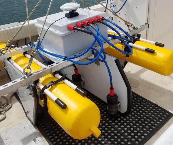
SQUID-5 - Structure-from-Motion Quantitative Underwater Imaging DeviceThe SQUID-5, or a Structure-from-Motion (SfM) Quantitative Underwater Imaging Device with 5 cameras is a towed surface vehicle with an onboard Global Navigation Satellite System (GNSS) and 5 downward-looking cameras with overlapping views of the seafloor.
SQUID-5 - Structure-from-Motion Quantitative Underwater Imaging Device
SQUID-5 - Structure-from-Motion Quantitative Underwater Imaging DeviceThe SQUID-5, or a Structure-from-Motion (SfM) Quantitative Underwater Imaging Device with 5 cameras is a towed surface vehicle with an onboard Global Navigation Satellite System (GNSS) and 5 downward-looking cameras with overlapping views of the seafloor.