



Two HVO geologists document road cutting activities on HWY 132 on August 7, 2019. One geologist is taking visual photographs while another geologist is taking thermal photographs to make a tandem pair for comparison. The temperature of the solidified lava was measured to 425 ° C (800 ° F) at the digging site. Photograph by USGS geologist K.
Images
Images related to natural hazards.
Filter Total Items: 7275

Why is the 2018 lava still so hot?
Two HVO geologists document road cutting activities on HWY 132 on August 7, 2019. One geologist is taking visual photographs while another geologist is taking thermal photographs to make a tandem pair for comparison. The temperature of the solidified lava was measured to 425 ° C (800 ° F) at the digging site. Photograph by USGS geologist K.

Still image from November 1, 2019, YVO video monthly update.
Still image from November 1, 2019, YVO video monthly update.Still image from November 1, 2019, YVO video monthly update.
Still image from November 1, 2019, YVO video monthly update.
Still image from November 1, 2019, YVO video monthly update.Still image from November 1, 2019, YVO video monthly update.

M7.1 Ridgecrest, California Earthquake Rupture Moletrack
M7.1 Ridgecrest, California Earthquake Rupture MoletrackBelle Philibosian field mapping the M7.1 Ridgecrest, California Earthquake Rupture, July 9, 2019.
M7.1 Ridgecrest, California Earthquake Rupture Moletrack
M7.1 Ridgecrest, California Earthquake Rupture MoletrackBelle Philibosian field mapping the M7.1 Ridgecrest, California Earthquake Rupture, July 9, 2019.

San Andreas Fault Near Bitterwater, California
Looking south along the creeping section of the San Andreas Fault near Bitterwater, California, September 23, 2019.
Looking south along the creeping section of the San Andreas Fault near Bitterwater, California, September 23, 2019.

Horse trek to GPS station HVWY.
Transportation takes many forms; this horse trek to GPS station HVWY in Hayden Valley complies with wilderness regulations, reduces impact to sensitive areas, and enables teams to upgrade equipment to keep the site operational year-round. Site maintenance was completed under permit YELL-2019-SCI-5546, in close coordination with Park staff, on September 18, 2019.
Transportation takes many forms; this horse trek to GPS station HVWY in Hayden Valley complies with wilderness regulations, reduces impact to sensitive areas, and enables teams to upgrade equipment to keep the site operational year-round. Site maintenance was completed under permit YELL-2019-SCI-5546, in close coordination with Park staff, on September 18, 2019.

Map of monitoring instruments in and around Yellowstone National Park as of Octo
Map of monitoring instruments in and around Yellowstone National Park as of OctoMap of monitoring instruments in and around Yellowstone National Park as of October 31, 2019. To view the interactive version of this map, go to the Yellowstone Volcano Observatory website.
Map of monitoring instruments in and around Yellowstone National Park as of Octo
Map of monitoring instruments in and around Yellowstone National Park as of OctoMap of monitoring instruments in and around Yellowstone National Park as of October 31, 2019. To view the interactive version of this map, go to the Yellowstone Volcano Observatory website.

This video shows a close-up of the unmanned aerial system collecting a water sam
This video shows a close-up of the unmanned aerial system collecting a water samThis video shows a close-up of the unmanned aerial system collecting a water sample in Halema‘uma‘u. USGS video by M. Patrick, 26 Oct 2019.
This video shows a close-up of the unmanned aerial system collecting a water sam
This video shows a close-up of the unmanned aerial system collecting a water samThis video shows a close-up of the unmanned aerial system collecting a water sample in Halema‘uma‘u. USGS video by M. Patrick, 26 Oct 2019.

Video of the water sampling at Kīlauea summit with unmanned aerial system
Video of the water sampling at Kīlauea summit with unmanned aerial systemThis video shows the unmanned aerial system collecting a water sample from Halema‘uma‘u. This wider view shows the scale of the UAS relative to the water pond. USGS video by M. Patrick, 26 Oct 2019.
Video of the water sampling at Kīlauea summit with unmanned aerial system
Video of the water sampling at Kīlauea summit with unmanned aerial systemThis video shows the unmanned aerial system collecting a water sample from Halema‘uma‘u. This wider view shows the scale of the UAS relative to the water pond. USGS video by M. Patrick, 26 Oct 2019.

Jim Smith Inside Lucchetti Dam in Puerto Rico
Jim Smith working on cabling inside of Lucchetti dam in Puerto Rico, assisting the Puerto Rico Strong Motion Program with Hurricane Maria recovery efforts.
Jim Smith working on cabling inside of Lucchetti dam in Puerto Rico, assisting the Puerto Rico Strong Motion Program with Hurricane Maria recovery efforts.

Ocean view from Fire Island, NY
Fire Island is a barrier island off the coast of Long Island, New York that hosts several protected areas, nesting habitat for shorebirds, and beachgoers looking for a relaxing place for recreation. USGS studies how the island changes over time - in both the past and present - to better understand how the island may evolve in the future.
Fire Island is a barrier island off the coast of Long Island, New York that hosts several protected areas, nesting habitat for shorebirds, and beachgoers looking for a relaxing place for recreation. USGS studies how the island changes over time - in both the past and present - to better understand how the island may evolve in the future.

Pre-flight inspection
USGS and OAS team prepares the sampling mechanism and inspects the unmanned aerial system a few minutes before mission start and takeoff. All safety precautions were taken to ensure the aircraft and sampling mechanism were sterile, and would return safely from the pond.
USGS and OAS team prepares the sampling mechanism and inspects the unmanned aerial system a few minutes before mission start and takeoff. All safety precautions were taken to ensure the aircraft and sampling mechanism were sterile, and would return safely from the pond.

Scott Lydeen at Strawberry Peak Seismic Station Tower
Scott Lydeen at Strawberry Peak Seismic Station TowerUSGS technicial Scott Lydeen climbing the tower at the Strawberry Peak seismic station tower, part of the Southern California Seismic Network.
Scott Lydeen at Strawberry Peak Seismic Station Tower
Scott Lydeen at Strawberry Peak Seismic Station TowerUSGS technicial Scott Lydeen climbing the tower at the Strawberry Peak seismic station tower, part of the Southern California Seismic Network.

Civil Air Patrol captured this aerial image of Mauna Loa's summit caldera, Moku&
Civil Air Patrol captured this aerial image of Mauna Loa's summit caldera, Moku&Civil Air Patrol captured this aerial image of Mauna Loa's summit caldera, Moku‘āweoweo, on Sunday, October 20, 2019. The true summit of Mauna Loa is located just to the right of the center of the image, at the highest location above the caldera wall in the background.
Civil Air Patrol captured this aerial image of Mauna Loa's summit caldera, Moku&
Civil Air Patrol captured this aerial image of Mauna Loa's summit caldera, Moku&Civil Air Patrol captured this aerial image of Mauna Loa's summit caldera, Moku‘āweoweo, on Sunday, October 20, 2019. The true summit of Mauna Loa is located just to the right of the center of the image, at the highest location above the caldera wall in the background.

Environmental Geoscience Fieldwork
Environmental geoscience fieldwork

High Altitude Station Maintenance on Mauna Loa
Sulphur Cone (left), viewed toward southwest, from 3,480 m (11,420 ft) above sea level on Mauna Loa's southwest rift zone. At right, an HVO geoscientist and technician rebuild volcanic gas monitoring equipment installed near an outgassing fissure.
Sulphur Cone (left), viewed toward southwest, from 3,480 m (11,420 ft) above sea level on Mauna Loa's southwest rift zone. At right, an HVO geoscientist and technician rebuild volcanic gas monitoring equipment installed near an outgassing fissure.

Continued slow rise of water level at bottom of Halema‘uma‘u
Continued slow rise of water level at bottom of Halema‘uma‘uThe water level at Kīlauea summit continues to slowly rise, with the size of the pond gradually enlarging. The pond today was at least 140 m (460 ft) in the east-west direction (from bottom to top of image). This length is a minimum estimate as the west end of the pond is now partially blocked from view by the crater walls. USGS photo by D. Swanson.
Continued slow rise of water level at bottom of Halema‘uma‘u
Continued slow rise of water level at bottom of Halema‘uma‘uThe water level at Kīlauea summit continues to slowly rise, with the size of the pond gradually enlarging. The pond today was at least 140 m (460 ft) in the east-west direction (from bottom to top of image). This length is a minimum estimate as the west end of the pond is now partially blocked from view by the crater walls. USGS photo by D. Swanson.
Black Dog breccia pipe is the remnant of an inactive hydrothermal vent system fo
Black Dog breccia pipe is the remnant of an inactive hydrothermal vent system foBlack Dog breccia pipe is the remnant of an inactive hydrothermal vent system fo
Black Dog breccia pipe is the remnant of an inactive hydrothermal vent system fo
Black Dog breccia pipe is the remnant of an inactive hydrothermal vent system foBlack Dog breccia pipe is the remnant of an inactive hydrothermal vent system fo

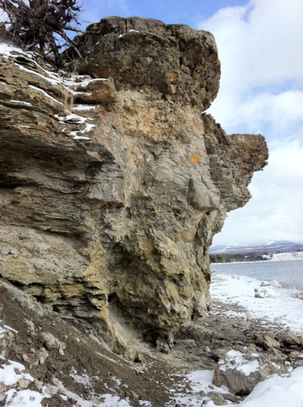
Breccia pipes forming within existing fractures along the western shore of Yello
Breccia pipes forming within existing fractures along the western shore of YelloMaterial filling the dissolved voids includes clasts of wall rock as well as beach sediments being washed into the voids. The lower structure on the left is about 0.7 m (2 ft) wide and 1.5 m (5 ft) high. Note the fracture alignment above the void structure on the right.
Breccia pipes forming within existing fractures along the western shore of Yello
Breccia pipes forming within existing fractures along the western shore of YelloMaterial filling the dissolved voids includes clasts of wall rock as well as beach sediments being washed into the voids. The lower structure on the left is about 0.7 m (2 ft) wide and 1.5 m (5 ft) high. Note the fracture alignment above the void structure on the right.

A closer look at the water surface. While most of the surface has a yellow-gree
A closer look at the water surface. While most of the surface has a yellow-greeA closer look at the water surface. While most of the surface has a yellow-green color, portions along the shoreline have a blue color and seem to correspond to areas of water upwelling. USGS photo by M. Patrick.
A closer look at the water surface. While most of the surface has a yellow-gree
A closer look at the water surface. While most of the surface has a yellow-greeA closer look at the water surface. While most of the surface has a yellow-green color, portions along the shoreline have a blue color and seem to correspond to areas of water upwelling. USGS photo by M. Patrick.

USGS PCMSC UAS
An remotely piloted aircraft (RPA) or drone, equipped with a camera, sits on the Arctic tundra awaiting a radio signal that tells it to fly.
An remotely piloted aircraft (RPA) or drone, equipped with a camera, sits on the Arctic tundra awaiting a radio signal that tells it to fly.

Low-oblique view of Barter Island bluffs
Example of a low-oblique photograph taken with an unmanned aerial system (UAS), or drone, of the coastal bluffs of Barter Island on North Slope of Alaska. The photographs from different time periods can be compared, using a technique called structure-from-motion photogrammetry, to measure changes in the coastal bluffs.
Example of a low-oblique photograph taken with an unmanned aerial system (UAS), or drone, of the coastal bluffs of Barter Island on North Slope of Alaska. The photographs from different time periods can be compared, using a technique called structure-from-motion photogrammetry, to measure changes in the coastal bluffs.