



The pond within Halema‘uma‘u has notably widened and deepened since August 15, as shown in these two photos taken on August 17 (right) and August 15 (left). Note the changes in the neck between the two ends of the pond. USGS photos by D. Swanson.
Images
Images related to natural hazards.
Filter Total Items: 7275

Halema‘uma‘u water pond on August 17
The pond within Halema‘uma‘u has notably widened and deepened since August 15, as shown in these two photos taken on August 17 (right) and August 15 (left). Note the changes in the neck between the two ends of the pond. USGS photos by D. Swanson.

Telephoto view of sulfur deposits at one of the several fumaroles on the north w
Telephoto view of sulfur deposits at one of the several fumaroles on the north wTelephoto view of sulfur deposits at one of the several fumaroles on the north wall of Halema‘uma‘u. USGS photo by D. Swanson, 08-14-2019.
Telephoto view of sulfur deposits at one of the several fumaroles on the north w
Telephoto view of sulfur deposits at one of the several fumaroles on the north wTelephoto view of sulfur deposits at one of the several fumaroles on the north wall of Halema‘uma‘u. USGS photo by D. Swanson, 08-14-2019.

Area of ponded water continues to enlarge in Halema‘uma‘u
Area of ponded water continues to enlarge in Halema‘uma‘uThe water level continues to slowly rise in Halema‘uma‘u, drowning many of the small rocks that were exposed in the center of the pond. Ripples across the water surface were also evident today.
Area of ponded water continues to enlarge in Halema‘uma‘u
Area of ponded water continues to enlarge in Halema‘uma‘uThe water level continues to slowly rise in Halema‘uma‘u, drowning many of the small rocks that were exposed in the center of the pond. Ripples across the water surface were also evident today.

Sunrise in Melbourne, FL
A colorful sunrise appears over the horizon of a calm ocean offshore of Melbourne, Florida. USGS Scientist RC Mickey collects data for location and elevation of sea turtle crawls and associated beach profiles this stretch of coastline.
A colorful sunrise appears over the horizon of a calm ocean offshore of Melbourne, Florida. USGS Scientist RC Mickey collects data for location and elevation of sea turtle crawls and associated beach profiles this stretch of coastline.

Women in Science - Responding to Ridgecrest, CA earthquake July 2019
Women in Science - Responding to Ridgecrest, CA earthquake July 2019USGS scientist Jessie Thompson Jobe measures fault offset at the site of the Ridgecrest earthquake sequence rupture. Photo credit: Chris DuRoss, USGS
Women in Science - Responding to Ridgecrest, CA earthquake July 2019
Women in Science - Responding to Ridgecrest, CA earthquake July 2019USGS scientist Jessie Thompson Jobe measures fault offset at the site of the Ridgecrest earthquake sequence rupture. Photo credit: Chris DuRoss, USGS

Women in Science - Responding to Ridgecrest, CA earthquake July 2019
Women in Science - Responding to Ridgecrest, CA earthquake July 2019USGS Pasadena Earthquake Response Coordinator Sue Hough, surveys displaced rocks near the southern end of the surface rupture of the 5 July 2019 M7.1 Ridgecrest earthquake. Photo credit: Sue Hough, USGS
Women in Science - Responding to Ridgecrest, CA earthquake July 2019
Women in Science - Responding to Ridgecrest, CA earthquake July 2019USGS Pasadena Earthquake Response Coordinator Sue Hough, surveys displaced rocks near the southern end of the surface rupture of the 5 July 2019 M7.1 Ridgecrest earthquake. Photo credit: Sue Hough, USGS

2019 Ridgecrest Earthquake Sequence: July 4, 2019–July 16, 2019
2019 Ridgecrest Earthquake Sequence: July 4, 2019–July 16, 20193,557 earthquakes recorded since July 4, 2019 above Magnitude 2
M6.4 12km W of Searles Valley, CA
2019-07-04 17:33:49 (UTC)
51,000+ responses via Did You Feel It?
M7.1 18km W of Searles Valley, CA
2019-07-06 03:19:53 (UTC)
42,000+ responses via Did You Feel It?
2019 Ridgecrest Earthquake Sequence: July 4, 2019–July 16, 2019
2019 Ridgecrest Earthquake Sequence: July 4, 2019–July 16, 20193,557 earthquakes recorded since July 4, 2019 above Magnitude 2
M6.4 12km W of Searles Valley, CA
2019-07-04 17:33:49 (UTC)
51,000+ responses via Did You Feel It?
M7.1 18km W of Searles Valley, CA
2019-07-06 03:19:53 (UTC)
42,000+ responses via Did You Feel It?

Women in Science - Responding to Ridgecrest, CA earthquake July 2019
Women in Science - Responding to Ridgecrest, CA earthquake July 2019Geologists with USGS, the California Geological Survey (CGS) and Naval Air Weapons Station China Lake (NAWS) worked together in response to the Ridgecrest earthquake sequence in California that occurred July 4-6, 2019. The earthquakes were large enough that the fault rupture reached the earth’s surface.
Women in Science - Responding to Ridgecrest, CA earthquake July 2019
Women in Science - Responding to Ridgecrest, CA earthquake July 2019Geologists with USGS, the California Geological Survey (CGS) and Naval Air Weapons Station China Lake (NAWS) worked together in response to the Ridgecrest earthquake sequence in California that occurred July 4-6, 2019. The earthquakes were large enough that the fault rupture reached the earth’s surface.

Women in Science - Responding to Ridgecrest, CA earthquake July 2019
Women in Science - Responding to Ridgecrest, CA earthquake July 2019USGS scientists Beth Haddon (left) and Jaime Delano (right) measuring an offset road at the site of the Ridgecrest earthquake sequence rupture. Photo credit: Chris DuRoss, USGS
Women in Science - Responding to Ridgecrest, CA earthquake July 2019
Women in Science - Responding to Ridgecrest, CA earthquake July 2019USGS scientists Beth Haddon (left) and Jaime Delano (right) measuring an offset road at the site of the Ridgecrest earthquake sequence rupture. Photo credit: Chris DuRoss, USGS

Women in Science - Responding to Ridgecrest, CA earthquake July 2019
Women in Science - Responding to Ridgecrest, CA earthquake July 2019USGS scientist Jessie Thompson Jobe collects and records information on earthquake surface ruptures observed along a roadway following the Ridgecrest earthquake sequence. Photo credit: Ryan Gold (USGS)
Women in Science - Responding to Ridgecrest, CA earthquake July 2019
Women in Science - Responding to Ridgecrest, CA earthquake July 2019USGS scientist Jessie Thompson Jobe collects and records information on earthquake surface ruptures observed along a roadway following the Ridgecrest earthquake sequence. Photo credit: Ryan Gold (USGS)

Women in Science - Responding to Ridgecrest, CA earthquake July 2019
Women in Science - Responding to Ridgecrest, CA earthquake July 2019USGS Pasadena Earthquake Response Coordinator surveys displaced rocks near the southern end of the surface rupture of the 5 July 2019 M7.1 Ridgecrest earthquake. USGS photograph. Photo credit: Sue Hough, USGS
Women in Science - Responding to Ridgecrest, CA earthquake July 2019
Women in Science - Responding to Ridgecrest, CA earthquake July 2019USGS Pasadena Earthquake Response Coordinator surveys displaced rocks near the southern end of the surface rupture of the 5 July 2019 M7.1 Ridgecrest earthquake. USGS photograph. Photo credit: Sue Hough, USGS

Women in Science - Responding to Ridgecrest, CA earthquake July 2019
Women in Science - Responding to Ridgecrest, CA earthquake July 2019USGS scientist Jaime Delano, observes a sand blow caused by liquefaction during the M7.1 Ridgecrest earthquake. Photo credit: Chris DuRoss
Women in Science - Responding to Ridgecrest, CA earthquake July 2019
Women in Science - Responding to Ridgecrest, CA earthquake July 2019USGS scientist Jaime Delano, observes a sand blow caused by liquefaction during the M7.1 Ridgecrest earthquake. Photo credit: Chris DuRoss

Elevation survey in the Jones River, Kingston, MA
Research scientist Meagan Gonneea and USGS intern Angela Trejo survey the Jones River in Kingston, MA. Removal of a dam across the Jones River began July 15, 2019, as a first step to restore river habitat, which is particularly critical for herring passage from the sea to inland lakes for spawning.
Research scientist Meagan Gonneea and USGS intern Angela Trejo survey the Jones River in Kingston, MA. Removal of a dam across the Jones River began July 15, 2019, as a first step to restore river habitat, which is particularly critical for herring passage from the sea to inland lakes for spawning.

Women in Science - Responding to Ridgecrest, CA earthquake July 2019
Women in Science - Responding to Ridgecrest, CA earthquake July 2019Kate Scharer examining striations along fault scarp while completing GPS survey of fault rupture. Here the fault has about 2.6 m of horizontal displacement and 0.5 m of vertical. The rake of the striations is 47 degrees. Photo credit: Jamie Delano, USGS
Women in Science - Responding to Ridgecrest, CA earthquake July 2019
Women in Science - Responding to Ridgecrest, CA earthquake July 2019Kate Scharer examining striations along fault scarp while completing GPS survey of fault rupture. Here the fault has about 2.6 m of horizontal displacement and 0.5 m of vertical. The rake of the striations is 47 degrees. Photo credit: Jamie Delano, USGS

Women in Science - Responding to Ridgecrest, CA earthquake July 2019
Women in Science - Responding to Ridgecrest, CA earthquake July 2019USGS Geophysicists Elizabeth Cochran and Nick VanDerElst install a seismometer on the base Photo credit: Ben Brooks, USGS
Women in Science - Responding to Ridgecrest, CA earthquake July 2019
Women in Science - Responding to Ridgecrest, CA earthquake July 2019USGS Geophysicists Elizabeth Cochran and Nick VanDerElst install a seismometer on the base Photo credit: Ben Brooks, USGS

SQUID-5 - Structure-from-Motion Quantitative Underwater Imaging Device
SQUID-5 - Structure-from-Motion Quantitative Underwater Imaging DeviceThe SQUID-5, or a Structure-from-Motion (SfM) Quantitative Underwater Imaging Device with 5 cameras is a towed surface vehicle with an onboard Global Navigation Satellite System (GNSS) and 5 downward-looking cameras with overlapping views of the seafloor.
SQUID-5 - Structure-from-Motion Quantitative Underwater Imaging Device
SQUID-5 - Structure-from-Motion Quantitative Underwater Imaging DeviceThe SQUID-5, or a Structure-from-Motion (SfM) Quantitative Underwater Imaging Device with 5 cameras is a towed surface vehicle with an onboard Global Navigation Satellite System (GNSS) and 5 downward-looking cameras with overlapping views of the seafloor.
Barry's wave, surge likely to affect beaches in four states
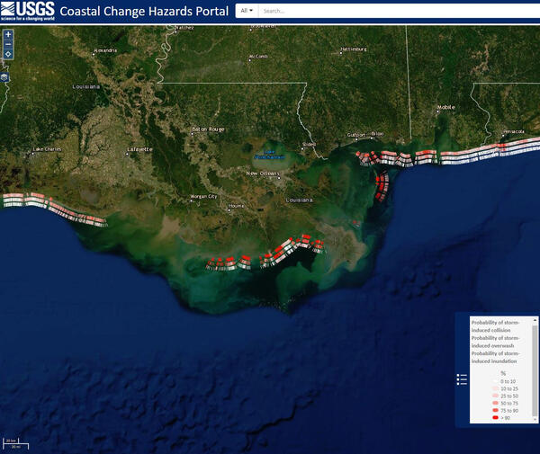
Barry's wave, surge likely to affect beaches in four statesThis Coastal Change Storm Hazard Team map was created Friday, July 12, 2019 and shows forecast beach erosion (the strip of colored bars closest to the coast), overwash (middle strip) and inundation (outer strip) effects of Tropical Storm Barry’s predicted landfall in Louisiana.
Barry's wave, surge likely to affect beaches in four states
Barry's wave, surge likely to affect beaches in four statesThis Coastal Change Storm Hazard Team map was created Friday, July 12, 2019 and shows forecast beach erosion (the strip of colored bars closest to the coast), overwash (middle strip) and inundation (outer strip) effects of Tropical Storm Barry’s predicted landfall in Louisiana.
Barry's wave, surge likely to affect beaches in four states
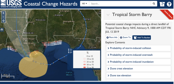
Barry's wave, surge likely to affect beaches in four statesThis Coastal Change Storm Hazard Team map was created Friday, July 12, 2019 and shows forecast beach erosion (the strip of colored bars closest to the coast), overwash (middle strip) and inundation (outer strip) effects of Tropical Storm Barry’s predicted landfall in Louisiana.
Barry's wave, surge likely to affect beaches in four states
Barry's wave, surge likely to affect beaches in four statesThis Coastal Change Storm Hazard Team map was created Friday, July 12, 2019 and shows forecast beach erosion (the strip of colored bars closest to the coast), overwash (middle strip) and inundation (outer strip) effects of Tropical Storm Barry’s predicted landfall in Louisiana.

These Gulf beaches are forecast to be affected by Barry
These Gulf beaches are forecast to be affected by BarryThis Coastal Change Storm Hazard Team map was created Thursday, July 11, 2019 and shows forecast beach erosion (the strip of colored bars closest to the coast), overwash (middle strip) and inundation (outer strip) effects of Tropical Storm Barry’s predicted landfall in Louisiana.
These Gulf beaches are forecast to be affected by Barry
These Gulf beaches are forecast to be affected by BarryThis Coastal Change Storm Hazard Team map was created Thursday, July 11, 2019 and shows forecast beach erosion (the strip of colored bars closest to the coast), overwash (middle strip) and inundation (outer strip) effects of Tropical Storm Barry’s predicted landfall in Louisiana.

Sulfur deposits on Halema‘uma‘u crater walls
Group of sulfur-depositing fumaroles overlook the pond of water in Halema‘uma‘u. USGS photo by D. Swanson, 08-14-2019.
Group of sulfur-depositing fumaroles overlook the pond of water in Halema‘uma‘u. USGS photo by D. Swanson, 08-14-2019.

Barry forecast to affect beaches in four Gulf states
Barry forecast to affect beaches in four Gulf statesThis Coastal Change Storm Hazard Team map was created Thursday, July 11, 2019 and shows forecast beach erosion (the strip of colored bars closest to the coast), overwash (middle strip) and inundation (outer strip) effects of Tropical Storm Barry’s predicted landfall in Louisiana.
Barry forecast to affect beaches in four Gulf states
Barry forecast to affect beaches in four Gulf statesThis Coastal Change Storm Hazard Team map was created Thursday, July 11, 2019 and shows forecast beach erosion (the strip of colored bars closest to the coast), overwash (middle strip) and inundation (outer strip) effects of Tropical Storm Barry’s predicted landfall in Louisiana.