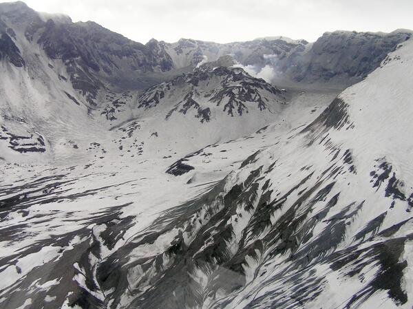
U.S. flag

An official website of the United States government

Images

Images related to natural hazards.

Filter Total Items: 7266
Remains of the dome camera/gas sampling station on Opus, after the ...
Remains of dome camera/gas sampling station on Opus, Jan 16, 2006

The camera is missing, wooden base and fiberglass housing are broken, gas intake tube is disconnected, and there are three holes in the roof, and, although not obvious here, the station is tilted eastward 10-20 degrees (i.e., away from the likely source of the explosion).

The camera is missing, wooden base and fiberglass housing are broken, gas intake tube is disconnected, and there are three holes in the roof, and, although not obvious here, the station is tilted eastward 10-20 degrees (i.e., away from the likely source of the explosion).

Opus area of the dome, looking towards new dome. Ash covering is fr...
Opus area of the dome. Ash covering is from event of Jan 16, 2005.

Opus area of the dome, looking towards new dome. Ash covering is from event of January 16, 2005.

Mount St. Helens' crater and new dome, from the west. Gash on top o...
Monitoring equipment installation on Mount St. Helens' dome. Camera...

Monitoring equipment installation on Mount St. Helens' dome. Camera/gas sampling station is to the right underneath helicopter. GPS/accelerometer (seismometer) spider is just visible as a speck on top of new dome.

Monitoring equipment installation on Mount St. Helens' dome. Camera/gas sampling station is to the right underneath helicopter. GPS/accelerometer (seismometer) spider is just visible as a speck on top of new dome.

Tilt-leg spider, a rapid-response instrument made to rest on top of...

Tilt-leg spider, a rapid-response instrument made to rest on top of the north-face of the 2005 Mount St. Helens lava dome. Includes GPS and seismometer.

Image: After Tsunami Destruction
After Tsunami Destruction

Sand and bricks deposited by the tsunami in an area of destruction on the East Coast of Sri Lanka at Kulmunai Kuddi.

Sand and bricks deposited by the tsunami in an area of destruction on the East Coast of Sri Lanka at Kulmunai Kuddi.

Image: After Tsunami Destruction
After Tsunami Destruction

Sand and bricks deposited by the tsunami in an area of destruction on the East Coast of Sri Lanka at Kulmunai Kuddi.

Sand and bricks deposited by the tsunami in an area of destruction on the East Coast of Sri Lanka at Kulmunai Kuddi.

Image: Measuring Tsunami Height
Measuring Tsunami Height

Dr. Starin Fernanda, Geological Survey & Mines Bureau of Sri Lanka, taking measurement of height of tsunami, indicated by gouge mark in tree from debris carried by the tsunami.

Dr. Starin Fernanda, Geological Survey & Mines Bureau of Sri Lanka, taking measurement of height of tsunami, indicated by gouge mark in tree from debris carried by the tsunami.

Was this page helpful?