
Shaded relief image of Nahant to Gloucester, MA
Images
Images related to natural hazards.
Filter Total Items: 7275

Shaded relief image of Nahant to Gloucester, MA
Shaded relief image of Nahant to Gloucester, MA

Vents and lava flows from the Kīlauea eruption of 1955
Vents and lava flows from the Kīlauea eruption of 1955This 88 day eruption spawned lava flows which crossed all major roads to lower Puna. Coastal villages from Kalapana to Kapoho were isolated. Major roads closed by lava included Pahoa-Pohoiki; Pahoa-Kapoho; Pahoa-Opihikao; and Pahoa-Kalapana as well as the lower Puna coastal highway.

Crater Lake is the remnant of Mount Mazama, which erupted catastrop...
Crater Lake is the remnant of Mount Mazama, which erupted catastrop...Crater Lake is the remnant of Mount Mazama, which erupted catastrophically 7,700 years ago to form the caldera.Wizard Island in lake and Mount Scott is peak on right shore. View from south. Oregon

Tsunami wave field in Bay of Bengal
Tsunami wave field in the Bay of Bengal one hour after the M=9.1 Sumatra-Andaman earthquake on December 26, 2004. View looks to the northwest.
Tsunami wave field in the Bay of Bengal one hour after the M=9.1 Sumatra-Andaman earthquake on December 26, 2004. View looks to the northwest.

Topographic map, Mount St. Helens, C.E. 1919 annotated with locatio...
Topographic map, Mount St. Helens, C.E. 1919 annotated with locatio...Due to the cataclysmic eruption of May 18, 1980, many of the locations annotated on this map are now either covered or no longer visible.
Topographic map, Mount St. Helens, C.E. 1919 annotated with locatio...
Topographic map, Mount St. Helens, C.E. 1919 annotated with locatio...Due to the cataclysmic eruption of May 18, 1980, many of the locations annotated on this map are now either covered or no longer visible.
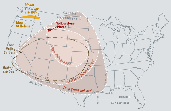
Map of the known ash-fall boundaries for several U.S. eruptions
Map of the known ash-fall boundaries for several U.S. eruptionsEruptions of the Yellowstone volcanic system have included the two largest volcanic eruptions in North America in the past few million years; the third largest was at Long Valley in California and produced the Bishop ash bed. The biggest of the Yellowstone eruptions occurred 2.1 million years ago, depositing the Huckleberry Ridge ash bed.

Shaded relief image of the Outer Cape Cod, MA
Shaded relief image of the Outer Cape Cod, MA
Shaded relief image of the Outer Cape Cod, MA

USGS Debris-flow flume near Blue River, OR is used to conduct debris flow and landslide experiments.
USGS Debris-flow flume near Blue River, OR is used to conduct debris flow and landslide experiments.USGS Debris-flow flume near Blue River, Oregon is used to conduct debris flows and landslide experiments. Flume is a reinforced concrete channel 95 m (310 ft long, 2 m (6.6 ft) wide, and 1.2 m (4 ft).

Crater Lake from the air viewed from SW. Wizard Island is the coni...
Crater Lake from the air viewed from SW. Wizard Island is the coni...Crater Lake from the air viewed from the southwest. Wizard Island is the conical mound in the lake and Mount Scott is the peak beyond the lake. Oregon
Crater Lake from the air viewed from SW. Wizard Island is the coni...
Crater Lake from the air viewed from SW. Wizard Island is the coni...Crater Lake from the air viewed from the southwest. Wizard Island is the conical mound in the lake and Mount Scott is the peak beyond the lake. Oregon

Mount Jefferson, OR, aerial view as seen from the west.
Mount Jefferson, OR, aerial view as seen from the west.Mount Jefferson, Oregon, aerial view as seen from the west.
Mount Jefferson, OR, aerial view as seen from the west.
Mount Jefferson, OR, aerial view as seen from the west.Mount Jefferson, Oregon, aerial view as seen from the west.

Mount Jefferson (pointed peak in middle) and Three Sisters (to righ...
Mount Jefferson (pointed peak in middle) and Three Sisters (to righ...Mount Jefferson (pointed peak in middle) and Three Sisters (to the right) in Oregon, south-facing aerial view as seen from Mount St. Helens.
Mount Jefferson (pointed peak in middle) and Three Sisters (to righ...
Mount Jefferson (pointed peak in middle) and Three Sisters (to righ...Mount Jefferson (pointed peak in middle) and Three Sisters (to the right) in Oregon, south-facing aerial view as seen from Mount St. Helens.

Mount Adams, WA as seen from Mount St. Helens (west). Trees are co...
Mount Adams, WA as seen from Mount St. Helens (west). Trees are co...Mount Adams, Washington as seen from Mount St. Helens (west). Trees are covered in frost in the foreground.
Mount Adams, WA as seen from Mount St. Helens (west). Trees are co...
Mount Adams, WA as seen from Mount St. Helens (west). Trees are co...Mount Adams, Washington as seen from Mount St. Helens (west). Trees are covered in frost in the foreground.

Drumbeat pattern of earthquakes on a webicorder plot (digital seism...
Drumbeat pattern of earthquakes on a webicorder plot (digital seism...The station recording this pattern of seismicity was called Yellow Rock (YEL), which was approximately 1 km north of the 2004-2008 vent. YEL was removed in 2007 before the advancing Crater Glacier reached it. The YEL site is now under a hundred or so feet of ice.

Vulcan Volcano at Petroglyph National Monument
The Vulcan Volcano at the Petroglyph National Monument viewed from the southwest.
The Vulcan Volcano at the Petroglyph National Monument viewed from the southwest.

JA Volcano at Petroglyph National Monument
Pathway leading to the JA volcano at the Petroglyph National Monument.
Pathway leading to the JA volcano at the Petroglyph National Monument.

Black Volcano at Petroglyph National Monument
The Black Volcano at the Petroglyph National Monument viewed from the southwest.
The Black Volcano at the Petroglyph National Monument viewed from the southwest.

Global Positioning System receiver (dome on pole) and seismometer
Global Positioning System receiver (dome on pole) and seismometerGlobal Positioning System receiver (dome on pole) and seismometer (box on ground in distance) at a volcano monitoring station for Three Sisters in Central Oregon. Solar panel mounted to pole.

Post-Hurricane Katrina
New Orleans, Louisiana following Hurricane Katrina.
New Orleans, Louisiana following Hurricane Katrina.


Mammoth Mountain Gondola
The loading station of the Mammoth Mountain gondola.
The loading station of the Mammoth Mountain gondola.

View from Mammoth Mountain Gondola
Viewing domes and craters from the Mammoth Mountain gondola.
Viewing domes and craters from the Mammoth Mountain gondola.