



Fissure 8 lava flows in an open channel all the way to the ocean. Kapoho Crater is the vegetated hill on the right side of the photograph. Ocean entry plume seen in the distance.
Images
Images related to natural hazards.
Filter Total Items: 7278

Kīlauea's LERZ
Fissure 8 lava flows in an open channel all the way to the ocean. Kapoho Crater is the vegetated hill on the right side of the photograph. Ocean entry plume seen in the distance.

Geologists track fissure activity in the LERZ
An HVO geologist uses a thermal camera to measure the temperature (about 93 degrees C or 200 degrees F) of a ground crack near fissure 9.
An HVO geologist uses a thermal camera to measure the temperature (about 93 degrees C or 200 degrees F) of a ground crack near fissure 9.
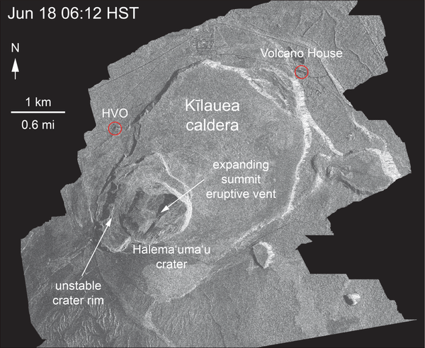
Kīlauea Volcano — Satellite Radar (Continued Slumping)
Kīlauea Volcano — Satellite Radar (Continued Slumping)This animated GIF shows a sequence of radar amplitude images that were acquired by the Agenzia Spaziale Italiana CosmoSkyMed satellite system. The images illustrate changes to the caldera area of Kīlauea Volcano that occurred between May 5 and June 18 at about 6:00 a.m. HST.
Kīlauea Volcano — Satellite Radar (Continued Slumping)
Kīlauea Volcano — Satellite Radar (Continued Slumping)This animated GIF shows a sequence of radar amplitude images that were acquired by the Agenzia Spaziale Italiana CosmoSkyMed satellite system. The images illustrate changes to the caldera area of Kīlauea Volcano that occurred between May 5 and June 18 at about 6:00 a.m. HST.

Kīlauea Volcano — Halema‘uma‘u Crater (June 18, 2018)
Kīlauea Volcano — Halema‘uma‘u Crater (June 18, 2018)Halema‘uma‘u viewed toward the west during the June 18 helicopter overflight. HVO and Jaggar Museum can barely be seen on the caldera rim in the upper right of the photograph.
Kīlauea Volcano — Halema‘uma‘u Crater (June 18, 2018)
Kīlauea Volcano — Halema‘uma‘u Crater (June 18, 2018)Halema‘uma‘u viewed toward the west during the June 18 helicopter overflight. HVO and Jaggar Museum can barely be seen on the caldera rim in the upper right of the photograph.

Kīlauea Volcano — Thermal Camera Measurement
An HVO geologist uses a thermal camera to measure the temperature (about 93 degrees C or 200 degrees F) of a ground crack near fissure 9.
An HVO geologist uses a thermal camera to measure the temperature (about 93 degrees C or 200 degrees F) of a ground crack near fissure 9.

Kīlauea Volcano — Halema`uma`u Crater
North side of the growing Halema‘uma‘u crater, marked by large cracks and large blocks that have slumped into the crater.
North side of the growing Halema‘uma‘u crater, marked by large cracks and large blocks that have slumped into the crater.

Kīlauea LERZ lava flows and fissures, June 18, 9:00 a.m.
Kīlauea LERZ lava flows and fissures, June 18, 9:00 a.m.Map as of 9:00 a.m. HST, June 18, 2018. Given the dynamic nature of Kīlauea's lower East Rift Zone eruption, with changing vent locations, fissures starting and stopping, and varying rates of lava effusion, map details shown here are accurate as of the date/time noted. Shaded purple areas indicate lava flows erupted in 1840, 1955, 1960, and 2014-2015.
Kīlauea LERZ lava flows and fissures, June 18, 9:00 a.m.
Kīlauea LERZ lava flows and fissures, June 18, 9:00 a.m.Map as of 9:00 a.m. HST, June 18, 2018. Given the dynamic nature of Kīlauea's lower East Rift Zone eruption, with changing vent locations, fissures starting and stopping, and varying rates of lava effusion, map details shown here are accurate as of the date/time noted. Shaded purple areas indicate lava flows erupted in 1840, 1955, 1960, and 2014-2015.
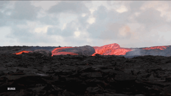
Kīlauea Volcano — Lava Flow (GIF)
An animated GIF showing lava bubbling out of fissure 8 at Kīlauea Volcano, Hawaii. Clip is taken from the full b-roll video listed as the source.
An animated GIF showing lava bubbling out of fissure 8 at Kīlauea Volcano, Hawaii. Clip is taken from the full b-roll video listed as the source.

Kīlauea Volcano — Fissure 8 Lava Flow
Fissure 8 cone and channelized lava flow.

Kīlauea Volcano —
Fissure 8 lava fountains obscured by a longer exposure photograph taken early morning on June 18. The incandescent spots along a horizontal line mark the edge of the lava channel.
Fissure 8 lava fountains obscured by a longer exposure photograph taken early morning on June 18. The incandescent spots along a horizontal line mark the edge of the lava channel.

North side of the growing Halema‘uma‘u, marked by large cracks and ...
North side of the growing Halema‘uma‘u, marked by large cracks and ...North side of the growing Halema‘uma‘u crater, marked by large cracks and large blocks that have slumped into the crater.
North side of the growing Halema‘uma‘u, marked by large cracks and ...
North side of the growing Halema‘uma‘u, marked by large cracks and ...North side of the growing Halema‘uma‘u crater, marked by large cracks and large blocks that have slumped into the crater.

lava at fissure 8 pulses above the cinder cone adding fragments of ...
lava at fissure 8 pulses above the cinder cone adding fragments of ...In this video taken from the Leilani Estates subdivision, lava at fissure 8 pulses above the cinder cone adding fragments of lava (spatter) that build the cone higher. From fissure 8, lava flows freely over small cascades (rapids) into a well-established channel. Near the vent, lava is traveling about 24 km per hour (15 mi per hour).
lava at fissure 8 pulses above the cinder cone adding fragments of ...
lava at fissure 8 pulses above the cinder cone adding fragments of ...In this video taken from the Leilani Estates subdivision, lava at fissure 8 pulses above the cinder cone adding fragments of lava (spatter) that build the cone higher. From fissure 8, lava flows freely over small cascades (rapids) into a well-established channel. Near the vent, lava is traveling about 24 km per hour (15 mi per hour).

Kīlauea Volcano — Halema`uma`u Crater
Inward slumping of the rim and walls of Halema‘uma‘u continues in response to ongoing subsidence at the summit. Sulfur dioxide emissions from the volcano's summit have dropped to levels that are about half those measured prior to the onset of the current episode of eruptive activity.
Inward slumping of the rim and walls of Halema‘uma‘u continues in response to ongoing subsidence at the summit. Sulfur dioxide emissions from the volcano's summit have dropped to levels that are about half those measured prior to the onset of the current episode of eruptive activity.

Kīlauea Volcano — Fissure 8
Morning overflight of Kīlauea Volcano's lower East Rift Zone by the Civil Air Patrol provides context for the location of the fissure 8 fountain and lava channel within the lower Puna District.
Morning overflight of Kīlauea Volcano's lower East Rift Zone by the Civil Air Patrol provides context for the location of the fissure 8 fountain and lava channel within the lower Puna District.

Thermal map of fissure system and lava flows
This thermal map shows the fissure system and lava flows as of 6 am on Saturday, June 16. The fountain at Fissure 8 remains active, with the lava flow entering the ocean at Kapoho. Very small, weak lava flows have been active recently near the Fissure 16/18 area. The black and white area is the extent of the thermal map.
This thermal map shows the fissure system and lava flows as of 6 am on Saturday, June 16. The fountain at Fissure 8 remains active, with the lava flow entering the ocean at Kapoho. Very small, weak lava flows have been active recently near the Fissure 16/18 area. The black and white area is the extent of the thermal map.

Kīlauea Volcano — Vacationland Laze Plume
Lava enters the ocean entry in the vicinity of Vacationland, producing a vigorous laze plume. Lava flowing into the ocean has built a delta of flows, rock rubble and black sand, which is over 320 acres in size.
Lava enters the ocean entry in the vicinity of Vacationland, producing a vigorous laze plume. Lava flowing into the ocean has built a delta of flows, rock rubble and black sand, which is over 320 acres in size.

Kīlauea Volcano — Lava Channels
Occasionally, minor amounts of lava briefly spill over the lava channel levees. The spill overs are the shiny gray lobes along the channel margins. The lava flow field has been relatively stable with little change to its size and shape over the past few days.
Occasionally, minor amounts of lava briefly spill over the lava channel levees. The spill overs are the shiny gray lobes along the channel margins. The lava flow field has been relatively stable with little change to its size and shape over the past few days.

The fissure 8 lava fountain pulses to heights of 50 m (165 ft) with...
The fissure 8 lava fountain pulses to heights of 50 m (165 ft) with...The fissure 8 lava fountain pulses to heights of 50 m (165 ft) within a cinder spatter cone. Fissure 8 feeds lava into the well-established channel that flows to the ocean.
The fissure 8 lava fountain pulses to heights of 50 m (165 ft) with...
The fissure 8 lava fountain pulses to heights of 50 m (165 ft) with...The fissure 8 lava fountain pulses to heights of 50 m (165 ft) within a cinder spatter cone. Fissure 8 feeds lava into the well-established channel that flows to the ocean.

Kīlauea Volcano — Lava Fountain
The fissure 8 lava fountain pulses to heights of 50 m (165 ft) within a cinder spatter cone. Fissure 8 feeds&nbs
The fissure 8 lava fountain pulses to heights of 50 m (165 ft) within a cinder spatter cone. Fissure 8 feeds&nbs

Kīlauea's LERZ
Morning overflight of Kīlauea Volcano's lower East Rift Zone by the Civil Air Patrol provides context for the location of the fissure 8 fountain and lava channel within the lower Puna District. View is to the north. Image courtesy of Civil Air Patrol.
Morning overflight of Kīlauea Volcano's lower East Rift Zone by the Civil Air Patrol provides context for the location of the fissure 8 fountain and lava channel within the lower Puna District. View is to the north. Image courtesy of Civil Air Patrol.

Kīlauea lower East Rift Zone
Fissure 8 continues to erupt, feeding lava to a perched channel that extends to the coast. The white laze plume at the distant ocean entry is visible just to the left of the gases rising from the fissure 8 cone (lower right).
Fissure 8 continues to erupt, feeding lava to a perched channel that extends to the coast. The white laze plume at the distant ocean entry is visible just to the left of the gases rising from the fissure 8 cone (lower right).