
A temporary GPS station (with radio telemetry for continuous measurement) was installed this week on the Kīlauea caldera floor to track the ongoing subsidence of the summit area. The data will help to characterize the extent and rate of the subsidence.
Images
Images related to natural hazards.
Filter Total Items: 7275

Kīlauea Volcano — GPS Station
A temporary GPS station (with radio telemetry for continuous measurement) was installed this week on the Kīlauea caldera floor to track the ongoing subsidence of the summit area. The data will help to characterize the extent and rate of the subsidence.

Fissure 8 lava fountains obscured by a longer exposure photograph t...
Fissure 8 lava fountains obscured by a longer exposure photograph t...Fissure 8 lava fountains obscured by a longer exposure photograph taken early morning on June 18. The incandescent spots along a horizontal line mark the edge of the lava channel. A tongue of incandescent lava leads down to the right - a small overflow from the channel margin.

Thermal map of fissure system and lava flows
This thermal map shows the fissure system and lava flows as of 6 am on Saturday, June 19. The fountain at Fissure 8 remains active, with the lava flow entering the ocean at Kapoho.The channel is very full and is overflowing to produce short pahoehoe lava flows that overtop the levees.
This thermal map shows the fissure system and lava flows as of 6 am on Saturday, June 19. The fountain at Fissure 8 remains active, with the lava flow entering the ocean at Kapoho.The channel is very full and is overflowing to produce short pahoehoe lava flows that overtop the levees.

Kīlauea Volcano — Fissure 8 Eruption (June 18-19, 2018)
Kīlauea Volcano — Fissure 8 Eruption (June 18-19, 2018)Fissure 8 vigor increased overnight June 18-19 with lava fountains reaching up to 60 m (200 ft). Spatter built up the cone to the east and into the channel.
Kīlauea Volcano — Fissure 8 Eruption (June 18-19, 2018)
Kīlauea Volcano — Fissure 8 Eruption (June 18-19, 2018)Fissure 8 vigor increased overnight June 18-19 with lava fountains reaching up to 60 m (200 ft). Spatter built up the cone to the east and into the channel.

Fissure 8 increased in vigor overnight
Fissure 8 vigor increased overnight June 18-19 with lava fountains reaching up to 60 m (200 ft). Spatter built up the cone to the east and into the channel. In this photograph, spatter lands on the east cone and flows downward.
Fissure 8 vigor increased overnight June 18-19 with lava fountains reaching up to 60 m (200 ft). Spatter built up the cone to the east and into the channel. In this photograph, spatter lands on the east cone and flows downward.

The northern channel margin of the fissure 8 lava flow. Small hill ...
The northern channel margin of the fissure 8 lava flow. Small hill ...The northern channel margin of the fissure 8 lava flow. Small hill in the distance is the site of our PGcam. Overflows from the channel can be seen producing shiny black to silver pahoehoe flows (incandescent red breakout visible in center of photo). These flows are building up the channel margins and making the levees more robust.

Halema‘uma‘u viewed toward the west during the June 18 helicopter o...
Halema‘uma‘u viewed toward the west during the June 18 helicopter o...Halema‘uma‘u viewed toward the west during the June 18 helicopter overflight. HVO and Jaggar Museum can barely be seen on the caldera rim in the upper right of the photograph.

Kīlauea Volcano — Fissure 8 Lava Flow
The northern channel margin of the fissure 8 lava flow. Small hill in the distance is the site of our PGcam. Overflows from the channel can be seen producing shiny black to silver pahoehoeflows (incandescent red breakout visible in center of photo).
The northern channel margin of the fissure 8 lava flow. Small hill in the distance is the site of our PGcam. Overflows from the channel can be seen producing shiny black to silver pahoehoeflows (incandescent red breakout visible in center of photo).

Kīlauea Volcano — Fissure 8 Lava Channel
Fissure 8 cone, lava fountain, and channelized lava flow on the morning overflight - June 19 at about 6:10am HST. The lava channel is very full with many small overflows visible on the channel margins. Overflows are sluggish and move slowly downslope as they build up the levees.
Fissure 8 cone, lava fountain, and channelized lava flow on the morning overflight - June 19 at about 6:10am HST. The lava channel is very full with many small overflows visible on the channel margins. Overflows are sluggish and move slowly downslope as they build up the levees.
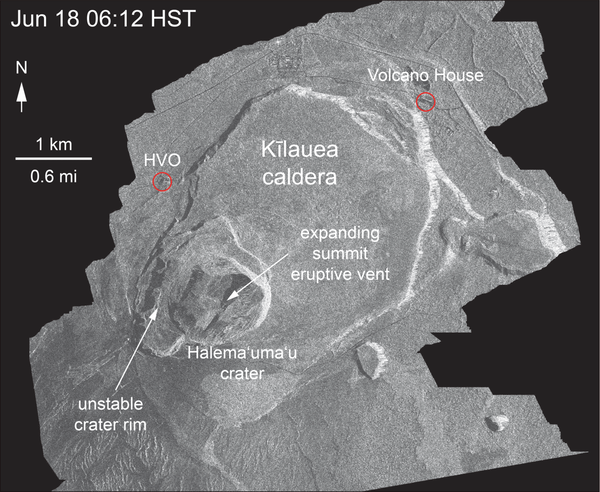
Satellite radar shows continued slumping of Halema‘uma‘u rim
Satellite radar shows continued slumping of Halema‘uma‘u rimThis animated GIF shows a sequence of radar amplitude images that were acquired by the Agenzia Spaziale Italiana CosmoSkyMed satellite system. The images illustrate changes to the caldera area of Kīlauea Volcano that occurred between May 5 and June 18 at about 6:00 a.m. HST.

Fissure 8 cone, lava fountain, and channelized lava flow on the mor...
Fissure 8 cone, lava fountain, and channelized lava flow on the mor...Fissure 8 cone, lava fountain, and channelized lava flow on the morning overflight - June 19 at about 6:10am HST. The lava channel is very full with many small overflows visible on the channel margins. Overflows are sluggish and move slowly downslope as they build up the levees.

June 18 summit overflight shows Halema‘uma‘u with HVO for perspective
June 18 summit overflight shows Halema‘uma‘u with HVO for perspectiveDuring the helicopter overflight on June 18, crews captured this image of the growing Halema‘uma‘u crater viewed to the southeast. With HVO and Jagger Museum sitting on the caldera rim (right side, middle where the road bends to the left) it is easier to comprehend the scale of subsidence at the summit.

Kīlauea LERZ lava flows and fissures, June 19, 1:00 p.m.
Kīlauea LERZ lava flows and fissures, June 19, 1:00 p.m.Map as of 1:00 p.m. HST, June 19, 2018. Given the dynamic nature of Kīlauea's lower East Rift Zone eruption, with changing vent locations, fissures starting and stopping, and varying rates of lava effusion, map details shown here are accurate as of the date/time noted. Shaded purple areas indicate lava flows erupted in 1840, 1955, 1960, and 2014-2015.

Kīlauea Volcano — Halema‘uma‘u Crater Slumping
An overflight of Kīlauea's summit on June 18 showed the continued dramatic slumping and collapse of the Halema‘uma‘u crater area. This photo shows the area north-northwest of Halema‘uma‘u near a GPS station, North Pit. This station has subsided about 60 m (197 ft) in the past week.
An overflight of Kīlauea's summit on June 18 showed the continued dramatic slumping and collapse of the Halema‘uma‘u crater area. This photo shows the area north-northwest of Halema‘uma‘u near a GPS station, North Pit. This station has subsided about 60 m (197 ft) in the past week.

Kīlauea Volcano — Fissure 8 Lava Channels

Helicopter overflight of the Halema‘uma‘u
An overflight of Kīlauea's summit on June 18 showed the continued dramatic slumping and collapse of the Halema‘uma‘u crater area. This photo shows the area north-northwest of Halema‘uma‘u near a GPS station, North Pit. This station has subsided about 60 m (197 ft) in the past week.
An overflight of Kīlauea's summit on June 18 showed the continued dramatic slumping and collapse of the Halema‘uma‘u crater area. This photo shows the area north-northwest of Halema‘uma‘u near a GPS station, North Pit. This station has subsided about 60 m (197 ft) in the past week.

Kīlauea Volcano — Fissure 6
Fissure 6 (photo center) showed signs of activity overnight, producing small amounts of spatter and feeding short lava flows. Fissure 6 is located about 2.2 km (1.4 mi) downrift from Fissure 8.
Fissure 6 (photo center) showed signs of activity overnight, producing small amounts of spatter and feeding short lava flows. Fissure 6 is located about 2.2 km (1.4 mi) downrift from Fissure 8.

Kīlauea Volcano — Halema`uma`u Crater (with HVO)
During the helicopter overflight on June 18, crews captured this image of the growing Halema‘uma‘u crater viewed to the southeast.
During the helicopter overflight on June 18, crews captured this image of the growing Halema‘uma‘u crater viewed to the southeast.

Kīlauea's LERZ
Fissure 8 lava flows in an open channel all the way to the ocean. Kapoho Crater is the vegetated hill on the right side of the photograph. Ocean entry plume seen in the distance.
Fissure 8 lava flows in an open channel all the way to the ocean. Kapoho Crater is the vegetated hill on the right side of the photograph. Ocean entry plume seen in the distance.

Geologists track fissure activity in the LERZ
An HVO geologist uses a thermal camera to measure the temperature (about 93 degrees C or 200 degrees F) of a ground crack near fissure 9.
An HVO geologist uses a thermal camera to measure the temperature (about 93 degrees C or 200 degrees F) of a ground crack near fissure 9.

Kīlauea Volcano — Thermal Camera Measurement
An HVO geologist uses a thermal camera to measure the temperature (about 93 degrees C or 200 degrees F) of a ground crack near fissure 9.
An HVO geologist uses a thermal camera to measure the temperature (about 93 degrees C or 200 degrees F) of a ground crack near fissure 9.