



LERZ Fissure 8 on June 5, 2018 - The sun is behind the observer taking this photo, making the plume appear bluish due to sunlight scattering by tiny sulfate aerosols. The gas plume is against a very dark cloud background, so that no backlighting is affecting the plume view. Photo credit: Allan Lerner, USGS Volunteer
Images
Images related to natural hazards.
Filter Total Items: 7278

Colorful plumes - can we see volcanic gases?
LERZ Fissure 8 on June 5, 2018 - The sun is behind the observer taking this photo, making the plume appear bluish due to sunlight scattering by tiny sulfate aerosols. The gas plume is against a very dark cloud background, so that no backlighting is affecting the plume view. Photo credit: Allan Lerner, USGS Volunteer

Colorful plumes - can we see volcanic gases?
A volcanic gas cloud over the LERZ on May 19, 2018 - In this picture, the sun is illuminating the volcanic gas plume from behind. The plume appears orange in color, as the blue component of the sunlight has been preferentially removed by scattering on tiny sulfate aerosols.
A volcanic gas cloud over the LERZ on May 19, 2018 - In this picture, the sun is illuminating the volcanic gas plume from behind. The plume appears orange in color, as the blue component of the sunlight has been preferentially removed by scattering on tiny sulfate aerosols.

Kīlauea Volcano — Kapoho Bay and Vacationland
Lava from fissure 8 travels about 13 km (8 mi) down a well established channel (visible in the center of the image) to an ocean entry at Kapoho. Lava is building a seaward delta that is approximately 320 acres in size. The view is to the southwest with the Kapoho area in the lower right.
Lava from fissure 8 travels about 13 km (8 mi) down a well established channel (visible in the center of the image) to an ocean entry at Kapoho. Lava is building a seaward delta that is approximately 320 acres in size. The view is to the southwest with the Kapoho area in the lower right.

Lava from fissure 8 travels about 13 km (8 mi) down a well establis...
Lava from fissure 8 travels about 13 km (8 mi) down a well establis...Lava from fissure 8 travels about 13 km (8 mi) down a well established channel (visible in the center of the image) to an ocean entry at Kapoho. Lava is building a seaward delta that is approximately 320 acres in size. The view is to the southwest with the Kapoho area in the lower right. The white plume is the vigorous ocean entry at Vacationland.
Lava from fissure 8 travels about 13 km (8 mi) down a well establis...
Lava from fissure 8 travels about 13 km (8 mi) down a well establis...Lava from fissure 8 travels about 13 km (8 mi) down a well established channel (visible in the center of the image) to an ocean entry at Kapoho. Lava is building a seaward delta that is approximately 320 acres in size. The view is to the southwest with the Kapoho area in the lower right. The white plume is the vigorous ocean entry at Vacationland.

View of the active ocean entry in the vicinity of Vacationland. The...
View of the active ocean entry in the vicinity of Vacationland. The...View of the active ocean entry in the vicinity of Vacationland. The interaction of hot lava with the ocean creates "laze", a corrosive seawater plume laden with hydrochloric acid and fine volcanic particles that can irritate the skin, eyes, and lungs, but that dissipates quickly with distance.
View of the active ocean entry in the vicinity of Vacationland. The...
View of the active ocean entry in the vicinity of Vacationland. The...View of the active ocean entry in the vicinity of Vacationland. The interaction of hot lava with the ocean creates "laze", a corrosive seawater plume laden with hydrochloric acid and fine volcanic particles that can irritate the skin, eyes, and lungs, but that dissipates quickly with distance.

Kīlauea Volcano — Halema`uma`u Slumping
At Kīlauea Volcano's summit, inward slumping of the rim and walls of Halema‘uma‘u continues in response to ongoing subsidence. In this view to the southwest taken after this morning's event, a section of dark-colored wall rock (center left) has detached and dropped downward into the crater.
At Kīlauea Volcano's summit, inward slumping of the rim and walls of Halema‘uma‘u continues in response to ongoing subsidence. In this view to the southwest taken after this morning's event, a section of dark-colored wall rock (center left) has detached and dropped downward into the crater.

Fissure activity and active ocean entry in Kīlauea's LERZ
Fissure activity and active ocean entry in Kīlauea's LERZFissure 8 produces a lava fountain that pulses to heights of 55 to 60 m (185 to 200 ft). Spattering has built a cinder cone that partially encircles fissure 8, now 51 m (170 ft) tall at its highest point. The steam in the foreground is the result of heavy morning rain falling on warm (not hot) tephra (lava fragments).
Fissure activity and active ocean entry in Kīlauea's LERZ
Fissure activity and active ocean entry in Kīlauea's LERZFissure 8 produces a lava fountain that pulses to heights of 55 to 60 m (185 to 200 ft). Spattering has built a cinder cone that partially encircles fissure 8, now 51 m (170 ft) tall at its highest point. The steam in the foreground is the result of heavy morning rain falling on warm (not hot) tephra (lava fragments).

Kīlauea Volcano — Vacationland Ocean Entry
View of the active ocean entry in the vicinity of Vacationland. The interaction of hot lava with the ocean creates "laze", a corrosive seawater plume laden with hydrochloric acid and fine volcanic particles that can irritate the skin, eyes, and lungs, but that dissipates quickly with distance.
View of the active ocean entry in the vicinity of Vacationland. The interaction of hot lava with the ocean creates "laze", a corrosive seawater plume laden with hydrochloric acid and fine volcanic particles that can irritate the skin, eyes, and lungs, but that dissipates quickly with distance.

Kilauea Volcano -- Lower East Rift Zone lava flows and fissures
Kilauea Volcano -- Lower East Rift Zone lava flows and fissuresMap as of 10:00 a.m. HST, June 15, 2018.

Kīlauea Volcano — Spatter Cone Building
Lava fountains from Fissure 8 reach heights of 200 ft overnight. The cinder and spatter cone that is building around the fissure is now about 165 ft at its highest point.
Lava fountains from Fissure 8 reach heights of 200 ft overnight. The cinder and spatter cone that is building around the fissure is now about 165 ft at its highest point.

Kīlauea Volcano — Fissure 8 Lava Fountain
Photograph taken during helicopter overflight captures fissure 8 lava fountain.
Photograph taken during helicopter overflight captures fissure 8 lava fountain.
Kīlauea Volcano — Halema`uma`u Crater Enlargement
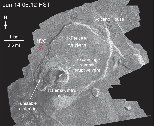
This animated GIF shows a sequence of radar amplitude images that were acquired by the Agenzia Spaziale Italiana CosmoSkyMed satellite system. The images illustrate changes to the caldera area of Kīlauea Volcano that occurred between May 5 and June 14 at about 6:00 a.m. HST.
This animated GIF shows a sequence of radar amplitude images that were acquired by the Agenzia Spaziale Italiana CosmoSkyMed satellite system. The images illustrate changes to the caldera area of Kīlauea Volcano that occurred between May 5 and June 14 at about 6:00 a.m. HST.

Thermal map of fissure system and lava flows
This thermal map shows the fissure system and lava flows as of 6 am on Thursday June 14. The fountain at Fissure 8 remains active, with the lava flow entering the ocean at Kapoho. Very small, weak lava flows have been active recently near the Fissure 16/18 area. The black and white area is the extent of the thermal map.
This thermal map shows the fissure system and lava flows as of 6 am on Thursday June 14. The fountain at Fissure 8 remains active, with the lava flow entering the ocean at Kapoho. Very small, weak lava flows have been active recently near the Fissure 16/18 area. The black and white area is the extent of the thermal map.
Satellite radar shows continued inward slumping of Halema‘uma‘u
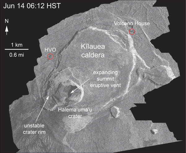
Satellite radar shows continued inward slumping of Halema‘uma‘uThis animated GIF shows a sequence of radar amplitude images that were acquired by the Agenzia Spaziale Italiana CosmoSkyMed satellite system. The images illustrate changes to the caldera area of Kīlauea Volcano that occurred between May 5 and June 14 at about 6:00 a.m. HST.
Satellite radar shows continued inward slumping of Halema‘uma‘u
Satellite radar shows continued inward slumping of Halema‘uma‘uThis animated GIF shows a sequence of radar amplitude images that were acquired by the Agenzia Spaziale Italiana CosmoSkyMed satellite system. The images illustrate changes to the caldera area of Kīlauea Volcano that occurred between May 5 and June 14 at about 6:00 a.m. HST.

Kīlauea Volcano — Ocean Entry
The ocean entry remains fairly broad with a white steam/laze plume blowing onshore. USGS image taken June 15, 2018.
The ocean entry remains fairly broad with a white steam/laze plume blowing onshore. USGS image taken June 15, 2018.

Kīlauea Volcano — Fissure 8 Cone Building
The Fissure 8 viewed from the north at 7:50 AM. The cone is roughly 50 m (165 ft) high at is peak, and a plume of sulfur dioxide and other volcanic gases rises as an orange tinge from the erupting lava fountains (hidden within the cone). Lava is still flowing out of the ventunabated as a full channel.
The Fissure 8 viewed from the north at 7:50 AM. The cone is roughly 50 m (165 ft) high at is peak, and a plume of sulfur dioxide and other volcanic gases rises as an orange tinge from the erupting lava fountains (hidden within the cone). Lava is still flowing out of the ventunabated as a full channel.

Wilderness breach at Fire Island in 2018
Breaching of Fire Island, NY occurred during Hurricane Sandy in 2012 (Wilderness Breach). Wilderness Breach in 2018 as seen from a low angle, note the other side of breached island is in the distance.
Breaching of Fire Island, NY occurred during Hurricane Sandy in 2012 (Wilderness Breach). Wilderness Breach in 2018 as seen from a low angle, note the other side of breached island is in the distance.

Kīlauea Volcano — Laze Plumes
Several laze plumes rise along the ocean entry margin as break outs feed many small and large flows. The largest Pāhoehoe breakout area is on the northern margin of the flow.
Several laze plumes rise along the ocean entry margin as break outs feed many small and large flows. The largest Pāhoehoe breakout area is on the northern margin of the flow.

Kīlauea Volcano — Pāhoehoe Breakouts
A close up view of the pāhoehoe breakouts along the northern ocean entry.
A close up view of the pāhoehoe breakouts along the northern ocean entry.

Kīlauea Volcano — Fissure 8
Fissure 8 lava fountain during this morning's overflight of the lower East Rift Zone.
Fissure 8 lava fountain during this morning's overflight of the lower East Rift Zone.

Kīlauea Volcano — Fissure 8
Fissure 8 fountains to heights of 130-140 ft. The lava spatter chills and the fragments are building a cone on the downwind side, now nearly as tall as the fountain itself.
Fissure 8 fountains to heights of 130-140 ft. The lava spatter chills and the fragments are building a cone on the downwind side, now nearly as tall as the fountain itself.