
August 2016 Louisiana Floods Completed
Learn more about USGS flood activities related to the August 2016 Louisana Floods.
Rainfall across Louisiana including amounts above 30 inches in some locations resulted in record-setting flooding. With over $8 billion in expected damages, the USGS responded with streamgage repairs, high-water mark collection, streamflow measurements, and assistance for 7 USGS employees whose own homes were damaged by the floods.

USGS Flood Event Viewer: USGS technicians and hydrologists, in partnership with FEMA, have collected hundreds of high-water marks and produce flood inundation maps. Click the image to enter the USGS Flood Event Viewer for this event.
Check out the published report: Characterization of Peak Streamflows and Flood Inundation of Selected Areas in Louisiana from the August 2016 Flood
FEMA disaster declaration (DR-4277): Incident period: August 11, 2016. Major Disaster Declaration declared on August 14, 2016.
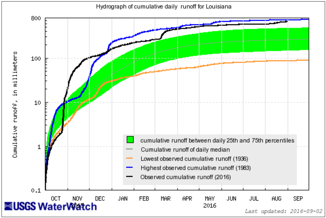
Regional Flooding: After winter flooding blew out the cumulative runoff record for Louisiana, spring rains and August rains continued to press 2016 toward being the heaviest runoff record on record for Louisiana.
Visit USGS WaterWatch for current flood conditions and other tools to explore flood and drought.
USGS Activities in the News:
- Documenting the Deluge: (9/2/2016) US Geological Survey teams search South Louisiana to determine recent flood's highest peak.
- USGS Records Historic Flooding in South Louisiana: (8/18/2016) Six streamgages Set peaks of record and 50 stations were overtopped by floodwaters.
- Wall Street Journal: Benchmark Used to Gauge Flood Size Can Muddy the Water. The Numbers explains why you don’t necessarily have to wait a century between ‘100-year floods.’
- The Advocate: Water mark studies to lend important lessons on Louisiana flood patterns.
Below are other science projects associated with this flood event.

Historical Flooding

September 2016 Northern Plains Floods

2016 Southern Spring Floods

January 2016 Noreaster

2015/2016 Winter Floods

Hurricane Matthew: Flood Resources and Tools
Learn more about USGS flood activities related to the August 2016 Louisana Floods.
Rainfall across Louisiana including amounts above 30 inches in some locations resulted in record-setting flooding. With over $8 billion in expected damages, the USGS responded with streamgage repairs, high-water mark collection, streamflow measurements, and assistance for 7 USGS employees whose own homes were damaged by the floods.
USGS Flood Event Viewer: USGS technicians and hydrologists, in partnership with FEMA, have collected hundreds of high-water marks and produce flood inundation maps. Click the image to enter the USGS Flood Event Viewer for this event.
Check out the published report: Characterization of Peak Streamflows and Flood Inundation of Selected Areas in Louisiana from the August 2016 Flood
FEMA disaster declaration (DR-4277): Incident period: August 11, 2016. Major Disaster Declaration declared on August 14, 2016.
Regional Flooding: After winter flooding blew out the cumulative runoff record for Louisiana, spring rains and August rains continued to press 2016 toward being the heaviest runoff record on record for Louisiana.
Visit USGS WaterWatch for current flood conditions and other tools to explore flood and drought.
USGS Activities in the News:
- Documenting the Deluge: (9/2/2016) US Geological Survey teams search South Louisiana to determine recent flood's highest peak.
- USGS Records Historic Flooding in South Louisiana: (8/18/2016) Six streamgages Set peaks of record and 50 stations were overtopped by floodwaters.
- Wall Street Journal: Benchmark Used to Gauge Flood Size Can Muddy the Water. The Numbers explains why you don’t necessarily have to wait a century between ‘100-year floods.’
- The Advocate: Water mark studies to lend important lessons on Louisiana flood patterns.
Below are other science projects associated with this flood event.