
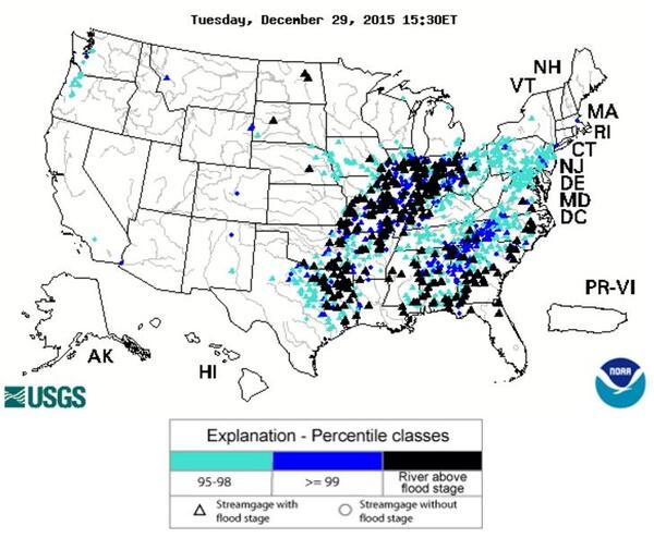
Learn more about USGS flood activities related to the 2015/2016 Winter Floods. In late Dec. 2015, persistent precipitation accompanied by strong winds and tornadoes blanketed two large bands of area from Texas to Ohio and Mississippi to North Carolina, causing localized flash flooding and then major flooding along the Missouri, Ohio, and Mississippi Rivers.

December Rainfall: Warmer-than-usual winter temperatures and an infusion of warm tropical moisture in late December, 2015 created conditions for heavy, sustained rainfall across large sections of the central and southern United States, with many areas experiencing 12 inches of rain or more.
Widespread Flooding: Flash floods that are normally confined to smaller regions were spread throughout large portions of the central and eastern United States. Runoff from these floods collected in the nation's tributaries and then concentrated into larger mainstem rivers. The USGS collected data from hundreds of special measurements and thousands of streamgaging stations, helping the National Weather Service to forecast river flooding and assisting the U.S. Army Corps of Engineers with reservoir management and water control.
Water Quality Monitoring: While flood levels are a primary concern, flooding also impacts water quality in ways that have short- and long-term impacts on drinking water and aquatic ecosystems. USGS collected water-quality samples from many sites to characterize changes in water quality.
USGS Activities in the News:
- Assessing the Magnitude of Missouri’s 2016 New Year's Flood: (10/13/2016) An assessment of the flooding that occurred in the Meramec River Basin from December 2015–January 2016...
- USGS Measures Historic Flooding Across the Nation: (1/4/2015) U.S. Geological Survey field crews are measuring record flooding on rivers and streams in 12 states across the country. USGS is making preparations for a prolonged field effort along the Ohio and Mississippi Rivers....
- USGS Records Historic Christmas Flooding in Arkansas: (12/31/2015) Currently more than 30 streamgages in Arkansas operated by the USGS experienced a “top 10” flood, meaning this flood event was one of the ten highest flood events ever recorded at these streamgages....
- USGS Measures Record Flooding in Missouri: (12/30/2015) USGS crews recorded 18 preliminary record-high flood measurements along the Meramac River. Additional historic peaks are expected throughout the southern part of the state over the next few days. Seven USGS crews are measuring high flood flows and verifying streamgage operations in the Arkansas, White, Gasconade and Meramec River valleys...
- Water Levels Surpass Records in Illinois River Basin: (12/29/2015) Since Saturday morning, parts of eastern Oklahoma received up to 12 inches of rain from Winter Storm Goliath. Water levels at many U.S. Geological Survey gages in that part of the state were already high due to previous rains...
- USGS Measures Flooding in Illinois: (12/28/2015) USGS field crews are taking streamflow measurements on the Kaskaskia River and the Metro East area around East St. Louis, Illinois. Additional crews are planning to monitor the Embarras River and the Little Wabash River...
- USGS Measures Flooding in Missouri: (12/27/2015) U.S. Geological Survey field crews are measuring flooding on rivers and streams across southwestern and southern Missouri and northeast into the St. Louis area...
- Springfield News-Leader: Flooding sets records on Missouri's Meramac River.
- Washington Post: Tracking the massive floods affecting the Midwest.
- CBS News: Mississippi River crests 12 feet above flood stage south of St. Louis.
- Southeast Missourian: Birds Point breach unlikely, but plans put in place just in case.
- Kansas City Star: Photo gallery: Flooding causes state of emergency in Missouri, Kansas also hit.
Below are other science projects associated with this flood event.

Historical Flooding

2015 Appalachian Floods and Hurricane Joaquin

Summer 2015 Central Floods
Learn more about USGS flood activities related to the 2015/2016 Winter Floods. In late Dec. 2015, persistent precipitation accompanied by strong winds and tornadoes blanketed two large bands of area from Texas to Ohio and Mississippi to North Carolina, causing localized flash flooding and then major flooding along the Missouri, Ohio, and Mississippi Rivers.
December Rainfall: Warmer-than-usual winter temperatures and an infusion of warm tropical moisture in late December, 2015 created conditions for heavy, sustained rainfall across large sections of the central and southern United States, with many areas experiencing 12 inches of rain or more.
Widespread Flooding: Flash floods that are normally confined to smaller regions were spread throughout large portions of the central and eastern United States. Runoff from these floods collected in the nation's tributaries and then concentrated into larger mainstem rivers. The USGS collected data from hundreds of special measurements and thousands of streamgaging stations, helping the National Weather Service to forecast river flooding and assisting the U.S. Army Corps of Engineers with reservoir management and water control.
Water Quality Monitoring: While flood levels are a primary concern, flooding also impacts water quality in ways that have short- and long-term impacts on drinking water and aquatic ecosystems. USGS collected water-quality samples from many sites to characterize changes in water quality.
USGS Activities in the News:
- Assessing the Magnitude of Missouri’s 2016 New Year's Flood: (10/13/2016) An assessment of the flooding that occurred in the Meramec River Basin from December 2015–January 2016...
- USGS Measures Historic Flooding Across the Nation: (1/4/2015) U.S. Geological Survey field crews are measuring record flooding on rivers and streams in 12 states across the country. USGS is making preparations for a prolonged field effort along the Ohio and Mississippi Rivers....
- USGS Records Historic Christmas Flooding in Arkansas: (12/31/2015) Currently more than 30 streamgages in Arkansas operated by the USGS experienced a “top 10” flood, meaning this flood event was one of the ten highest flood events ever recorded at these streamgages....
- USGS Measures Record Flooding in Missouri: (12/30/2015) USGS crews recorded 18 preliminary record-high flood measurements along the Meramac River. Additional historic peaks are expected throughout the southern part of the state over the next few days. Seven USGS crews are measuring high flood flows and verifying streamgage operations in the Arkansas, White, Gasconade and Meramec River valleys...
- Water Levels Surpass Records in Illinois River Basin: (12/29/2015) Since Saturday morning, parts of eastern Oklahoma received up to 12 inches of rain from Winter Storm Goliath. Water levels at many U.S. Geological Survey gages in that part of the state were already high due to previous rains...
- USGS Measures Flooding in Illinois: (12/28/2015) USGS field crews are taking streamflow measurements on the Kaskaskia River and the Metro East area around East St. Louis, Illinois. Additional crews are planning to monitor the Embarras River and the Little Wabash River...
- USGS Measures Flooding in Missouri: (12/27/2015) U.S. Geological Survey field crews are measuring flooding on rivers and streams across southwestern and southern Missouri and northeast into the St. Louis area...
- Springfield News-Leader: Flooding sets records on Missouri's Meramac River.
- Washington Post: Tracking the massive floods affecting the Midwest.
- CBS News: Mississippi River crests 12 feet above flood stage south of St. Louis.
- Southeast Missourian: Birds Point breach unlikely, but plans put in place just in case.
- Kansas City Star: Photo gallery: Flooding causes state of emergency in Missouri, Kansas also hit.
Below are other science projects associated with this flood event.
Historical Flooding
2015 Appalachian Floods and Hurricane Joaquin