



Interagency Flood-Typing and Mixed Population Studies
Flooding is a natural hazard that can cause extensive damage, result in casualties, loss of life and property, and shape landscapes. Understanding more about what caused past flood events, from snowmelt to excessive rainfall, can support future decision-making. The U.S. Geological Survey and U.S. Army Corps of Engineers (USACE) are collaboratively supporting the Federal Emergency Management Agency (FEMA) in meeting its goals to help improve risk-informed flood-frequency information.
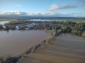
Flood frequency analysis (FFA) is essential for flood insurance studies, floodplain management, and the design of transportation infrastructure. Flood risk estimates are most useful when they can be applied consistently across locations, because managing the Nation’s water and land resources requires coordination among multiple levels of government and the private sector.
Federal guidelines for performing peak-flow FFA in the United States are presented in Bulletin 17C (England et al., 2019). These methods generally assume that the largest flood each year is produced by similar processes. However, floods can have different causes, including snowmelt, rainfall, rain falling on snow, hurricanes, or a combination of these factors. These different types of floods can behave differently, and not accounting for those differences can lead to inaccurate estimates of flood risk.
The U.S. Geological Survey (USGS) and the U.S. Army Corps of Engineers (USACE) are in the final year of a four-year Interagency Reimbursable Work Agreement to support the Federal Emergency Management Agency (FEMA) in meeting its goals of developing a risk-informed National Flood Insurance Program for the Risk Management Directorate implementing the Future of Flood Risk Data (FFRD) initiative.
The USGS and USACE have collaborated to achieve four priorities to help enable improved flood-frequency methods needed to support the FFRD:
- Identify improved Flood Frequency Analysis (FFA) methods for use at select USGS stations with long-term streamgage data in the United States based on physical and causal mechanisms.
- Develop and test semiautomated methods for determining flood-type classifications at USGS streamgages across the United States.
- Identify changes in the proportion of flood types.
- Implement a plan for the National FFRD initiative, including training of Federal employees.
Pilot Hydroclimatic Regions
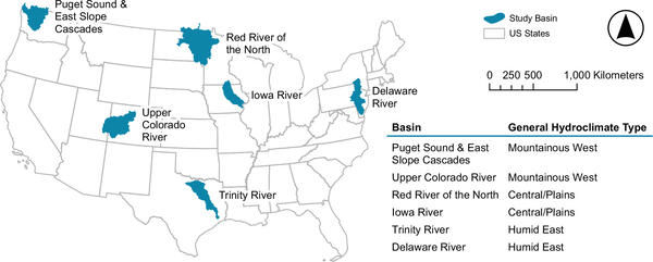
Three large-scale "meta regions" representing relatively uniform hydroclimatic conditions within the United States were identified to develop FFA and flood-type classification methodologies: the (1) Mountainous West, (2) Central/Plains, and (3) Humid East. Two watersheds (one for calibration and one for validation) were selected within each meta region (for a total of six watersheds). The pilot watersheds are shown in the figure to the left.
Development of Flood-Typing Methods
Classifying past annual flood events, or “flood-typing,” is based on a combination of weather events and watershed conditions (Hamshaw and others, 2026):
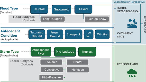
- Flood Type: Flood types can be classified as rainfall, snowmelt, or mixed, such as rain-on-snow events.
- Antecedent Conditions: Additional hydrologic conditions such as saturated ground, frozen ground, snowpack, ice jam, or wildfire, as applicable.
- Storm Type: The weather system associated with the flood, which can include atmospheric rivers, mid-latitude cyclones, or tropical storms (hurricanes) and their remnants. Storm subtypes, such as high-pressure, frontal, or monsoon are also determined when applicable. Although a given flood peak might be associated with multiple weather systems of different types, a single dominant storm type is identified with the classification of storm types when applicable.
- Basin-Specific Considerations: Flood causes vary among river basins due to differences in climate, topography, geology, and other watershed characteristics. In Hamshaw and others, 2026, the authors applied innovative basin-specific considerations into their flood-typing methodology.
To help determine the flood types, the study team use a combination of:
- USGS streamgage data;
- Hydroclimatic data, such as precipitation, snow-water-equivalent, and air temperature, for example; and
- Historical U.S. weather data from the National Oceanic and Atmospheric Administration (NOAA).
In addition to storm descriptions from NOAA, the study team also use post-flood reports published by USACE and the USGS, which contain valuable information about the meteorological and hydrologic conditions prior to and during large flood events.
Building a Framework to Inform Flood Risk
USGS and USACE scientists and engineers have led two parallel efforts to improve FFA and advance the goal of consistent flood typing classifications and mixed population methodologies.
Flood-Typing
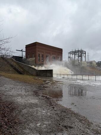
The USGS and USACE are working together to develop a consistent approach for classifying floods by their causes and contributing conditions. This flood-typing schema can be used to classify floods from different river basins and advance future risk analysis.
Flood typing efforts require the manual classification of annual flood events by domain experts. National and regional subject-matter experts (for example, hydrologists and hydraulic engineers) from USACE and the USGS worked together to develop flood-typing classifications using the combination of daily weather maps, historical publications, and gridded hydrometeorological data. Since domain expertise is often limited in their reproducibility and scaling to larger datasets, further development and testing of automated methods could result in flood typing that is more detailed for individual basins and regions.
In Hamshaw and others, 2026, the intention of the manual flood-typing investigation was to develop a consistent framework that could be used to develop a benchmark dataset for future work. They performed flood-mechanism classification for three long-term USGS streamgages in each pilot basin. The resultant data are published here.
Addition work was completed to evaluate the best performing gridded hydrometerological data for manual and semi-automated flood typing analysis (Irizarry-Ortiz and Murphy, 2025).
Flood-classification frameworks that accommodate aggregating results on a region-by-region basis approach could enhance development of comprehensive ground-truth datasets.
Mixed Population Methods
In addition to the flood-typing work to advance FFA, the USGS is co-leading the evaluation of different statistical methods for analyzing mixed population flood frequency analysis. These methods, which are referred to as Mixed Population Methods, inform FFA by incorporating multiple flood generating causal mechanisms, for example, into the frequency analysis. The USGS and USACE are applying the flood type classifications from the Pilot Regions as described above to evaluate Mixed Population Methods with the goal to help establish guidance for nationwide FFA.

USGS Flood Information
Flooding is a natural hazard that can cause extensive damage, result in casualties, loss of life and property, and shape landscapes. Understanding more about what caused past flood events, from snowmelt to excessive rainfall, can support future decision-making. The U.S. Geological Survey and U.S. Army Corps of Engineers (USACE) are collaboratively supporting the Federal Emergency Management Agency (FEMA) in meeting its goals to help improve risk-informed flood-frequency information.
Flood frequency analysis (FFA) is essential for flood insurance studies, floodplain management, and the design of transportation infrastructure. Flood risk estimates are most useful when they can be applied consistently across locations, because managing the Nation’s water and land resources requires coordination among multiple levels of government and the private sector.
Federal guidelines for performing peak-flow FFA in the United States are presented in Bulletin 17C (England et al., 2019). These methods generally assume that the largest flood each year is produced by similar processes. However, floods can have different causes, including snowmelt, rainfall, rain falling on snow, hurricanes, or a combination of these factors. These different types of floods can behave differently, and not accounting for those differences can lead to inaccurate estimates of flood risk.
The U.S. Geological Survey (USGS) and the U.S. Army Corps of Engineers (USACE) are in the final year of a four-year Interagency Reimbursable Work Agreement to support the Federal Emergency Management Agency (FEMA) in meeting its goals of developing a risk-informed National Flood Insurance Program for the Risk Management Directorate implementing the Future of Flood Risk Data (FFRD) initiative.
The USGS and USACE have collaborated to achieve four priorities to help enable improved flood-frequency methods needed to support the FFRD:
- Identify improved Flood Frequency Analysis (FFA) methods for use at select USGS stations with long-term streamgage data in the United States based on physical and causal mechanisms.
- Develop and test semiautomated methods for determining flood-type classifications at USGS streamgages across the United States.
- Identify changes in the proportion of flood types.
- Implement a plan for the National FFRD initiative, including training of Federal employees.
Pilot Hydroclimatic Regions
Three large-scale "meta regions" representing relatively uniform hydroclimatic conditions within the United States were identified to develop FFA and flood-type classification methodologies: the (1) Mountainous West, (2) Central/Plains, and (3) Humid East. Two watersheds (one for calibration and one for validation) were selected within each meta region (for a total of six watersheds). The pilot watersheds are shown in the figure to the left.
Development of Flood-Typing Methods
Classifying past annual flood events, or “flood-typing,” is based on a combination of weather events and watershed conditions (Hamshaw and others, 2026):
- Flood Type: Flood types can be classified as rainfall, snowmelt, or mixed, such as rain-on-snow events.
- Antecedent Conditions: Additional hydrologic conditions such as saturated ground, frozen ground, snowpack, ice jam, or wildfire, as applicable.
- Storm Type: The weather system associated with the flood, which can include atmospheric rivers, mid-latitude cyclones, or tropical storms (hurricanes) and their remnants. Storm subtypes, such as high-pressure, frontal, or monsoon are also determined when applicable. Although a given flood peak might be associated with multiple weather systems of different types, a single dominant storm type is identified with the classification of storm types when applicable.
- Basin-Specific Considerations: Flood causes vary among river basins due to differences in climate, topography, geology, and other watershed characteristics. In Hamshaw and others, 2026, the authors applied innovative basin-specific considerations into their flood-typing methodology.
To help determine the flood types, the study team use a combination of:
- USGS streamgage data;
- Hydroclimatic data, such as precipitation, snow-water-equivalent, and air temperature, for example; and
- Historical U.S. weather data from the National Oceanic and Atmospheric Administration (NOAA).
In addition to storm descriptions from NOAA, the study team also use post-flood reports published by USACE and the USGS, which contain valuable information about the meteorological and hydrologic conditions prior to and during large flood events.
Building a Framework to Inform Flood Risk
USGS and USACE scientists and engineers have led two parallel efforts to improve FFA and advance the goal of consistent flood typing classifications and mixed population methodologies.
Flood-Typing
The USGS and USACE are working together to develop a consistent approach for classifying floods by their causes and contributing conditions. This flood-typing schema can be used to classify floods from different river basins and advance future risk analysis.
Flood typing efforts require the manual classification of annual flood events by domain experts. National and regional subject-matter experts (for example, hydrologists and hydraulic engineers) from USACE and the USGS worked together to develop flood-typing classifications using the combination of daily weather maps, historical publications, and gridded hydrometeorological data. Since domain expertise is often limited in their reproducibility and scaling to larger datasets, further development and testing of automated methods could result in flood typing that is more detailed for individual basins and regions.
In Hamshaw and others, 2026, the intention of the manual flood-typing investigation was to develop a consistent framework that could be used to develop a benchmark dataset for future work. They performed flood-mechanism classification for three long-term USGS streamgages in each pilot basin. The resultant data are published here.
Addition work was completed to evaluate the best performing gridded hydrometerological data for manual and semi-automated flood typing analysis (Irizarry-Ortiz and Murphy, 2025).
Flood-classification frameworks that accommodate aggregating results on a region-by-region basis approach could enhance development of comprehensive ground-truth datasets.
Mixed Population Methods
In addition to the flood-typing work to advance FFA, the USGS is co-leading the evaluation of different statistical methods for analyzing mixed population flood frequency analysis. These methods, which are referred to as Mixed Population Methods, inform FFA by incorporating multiple flood generating causal mechanisms, for example, into the frequency analysis. The USGS and USACE are applying the flood type classifications from the Pilot Regions as described above to evaluate Mixed Population Methods with the goal to help establish guidance for nationwide FFA.