Volcano monitoring station KWBU at Newberry volcano
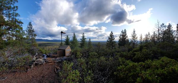
Volcano monitoring station KWBU at Newberry volcanoThe USGS Cascades Volcano Observatory installed an 8-station seismic monitoring network at Newberry volcano in 2011, which includes station KWBU.

Official websites use .gov
A .gov website belongs to an official government organization in the United States.
Secure .gov websites use HTTPS
A lock () or https:// means you’ve safely connected to the .gov website. Share sensitive information only on official, secure websites.
Images related to Cascades Volcano Observatory.

The USGS Cascades Volcano Observatory installed an 8-station seismic monitoring network at Newberry volcano in 2011, which includes station KWBU.
The USGS Cascades Volcano Observatory installed an 8-station seismic monitoring network at Newberry volcano in 2011, which includes station KWBU.

USGS scientist Laura Clor performing maintenance on the SNIF multi-GAS station on Mount St. Helens, Washington.
USGS scientist Laura Clor performing maintenance on the SNIF multi-GAS station on Mount St. Helens, Washington.

Interior of the SNIF multi-GAS enclosure on Mount St. Helens, Washington
Interior of the SNIF multi-GAS enclosure on Mount St. Helens, Washington

Scientists use a MultiGAS instrument (gray, hard-shell case) to measure gas compositions from the East Lake hot spring in the Newberry caldera. The photo was taken on August 3, 2020 just after sunrise. The vapor above the hot spring and lake is typical for cool mornings and is not visible later in the day.
Scientists use a MultiGAS instrument (gray, hard-shell case) to measure gas compositions from the East Lake hot spring in the Newberry caldera. The photo was taken on August 3, 2020 just after sunrise. The vapor above the hot spring and lake is typical for cool mornings and is not visible later in the day.

USGS-Cascades Volcano Observatory geophysicist Rebecca Kramer works on station PR05, which is part of the Mount Rainier lahar detection network (Mount Rainier is pictured in the distance). The purpose of the site visit was to upgrade the power system and deploy infrasound equipment.
USGS-Cascades Volcano Observatory geophysicist Rebecca Kramer works on station PR05, which is part of the Mount Rainier lahar detection network (Mount Rainier is pictured in the distance). The purpose of the site visit was to upgrade the power system and deploy infrasound equipment.

Earthquakes at Mount Rainier from 2010 to 2019. As shown in the graphic, fluids from the magmatic system beneath the volcano rise through existing cracks and weaknesses in the crust. Along with rainwater and ice/snow melt, these fluids combine to create a hydrothermal system within the volcano.
Earthquakes at Mount Rainier from 2010 to 2019. As shown in the graphic, fluids from the magmatic system beneath the volcano rise through existing cracks and weaknesses in the crust. Along with rainwater and ice/snow melt, these fluids combine to create a hydrothermal system within the volcano.
The USGS Cascades Volcano Observatory installed monitoring station ASBU near Newberry volcano in central Oregon in 2011.
The USGS Cascades Volcano Observatory installed monitoring station ASBU near Newberry volcano in central Oregon in 2011.

The GeoGirls visit a volcano monitoring station on the east side of Mount St. Helens, finding out how scientists use different monitoring methods (seismic, GPS, tiltmeter) to understand more about the volcano.
The GeoGirls visit a volcano monitoring station on the east side of Mount St. Helens, finding out how scientists use different monitoring methods (seismic, GPS, tiltmeter) to understand more about the volcano.

GeoGirls 2019 group photo, with Mount St. Helens in the background.
GeoGirls 2019 group photo, with Mount St. Helens in the background.

GeoGirls hike to Willow Creek, on Mount St. Helens’ Pumice Plain, to learn more about the ecology of the blast zone and how the area has recovered since the catastrophic May 18, 1980, eruption. Here, they look at stream characteristics and how it has influenced the return of life to the area.
GeoGirls hike to Willow Creek, on Mount St. Helens’ Pumice Plain, to learn more about the ecology of the blast zone and how the area has recovered since the catastrophic May 18, 1980, eruption. Here, they look at stream characteristics and how it has influenced the return of life to the area.

The GeoGirls create field drawings of 1980 pyroclastic flow deposits on Mount St. Helens’ Pumice Plain.
The GeoGirls create field drawings of 1980 pyroclastic flow deposits on Mount St. Helens’ Pumice Plain.

The GeoGirls hike the Pumice Plain at Mount St. Helens, examining lava outcrops and volcanic sediment.
The GeoGirls hike the Pumice Plain at Mount St. Helens, examining lava outcrops and volcanic sediment.

GeoGirls venture into Ape Cave, a 2,000-year-old lava tube on the south flank of Mount St. Helens, as they learn about Mount St. Helens’ eruptive history and lava flows.
GeoGirls venture into Ape Cave, a 2,000-year-old lava tube on the south flank of Mount St. Helens, as they learn about Mount St. Helens’ eruptive history and lava flows.

GeoGirls venture into Ape Cave, a 2,000-year-old lava tube on the south flank of Mount St. Helens, as they learn about Mount St. Helens’ eruptive history and lava flows.
GeoGirls venture into Ape Cave, a 2,000-year-old lava tube on the south flank of Mount St. Helens, as they learn about Mount St. Helens’ eruptive history and lava flows.

USGS Cascades Volcano Observatory staff, June 2019
USGS Cascades Volcano Observatory staff, June 2019

A field team from the USGS Cascades Volcano Observatory discuss station maintenance plans on the north side of Mount St. Helens, Washington. Pictured in the center of the crater is a steaming lava dome from the 2004-08 eruption, and the fractured surface of Crater Glacier emerging from the gap on the north flank.
A field team from the USGS Cascades Volcano Observatory discuss station maintenance plans on the north side of Mount St. Helens, Washington. Pictured in the center of the crater is a steaming lava dome from the 2004-08 eruption, and the fractured surface of Crater Glacier emerging from the gap on the north flank.

The sun rises at Mount St. Helens (pictured in the distance), with low-level clouds covering Coldwater Lake. The view is from the Coldwater Science and Learning Center, the site of the 2018 GeoGirls field camp program.
The sun rises at Mount St. Helens (pictured in the distance), with low-level clouds covering Coldwater Lake. The view is from the Coldwater Science and Learning Center, the site of the 2018 GeoGirls field camp program.

GeoGirls analyze volcanic sediment at the Coldwater Lake outlet.
GeoGirls analyze volcanic sediment at the Coldwater Lake outlet.

GeoGirls take core samples at a pond near the Hummocks Trail to study groundwater transport.
GeoGirls take core samples at a pond near the Hummocks Trail to study groundwater transport.

Mount St. Helens erupted 38 years ago, May 18, 1980
Mount St. Helens erupted 38 years ago, May 18, 1980

Example Hydrotherm output. Hydrotherm is a three-dimensional simulation of multiphase groundwater flow and heat transport in the temperature range of 0 to 1200 degrees Celsius and the pressure range of 1 to 1000 MPa.
Example Hydrotherm output. Hydrotherm is a three-dimensional simulation of multiphase groundwater flow and heat transport in the temperature range of 0 to 1200 degrees Celsius and the pressure range of 1 to 1000 MPa.