Helicopter dropping off monitoring equipment at Mount St. Helens, WA.
Helicopter dropping off monitoring equipment at Mount St. Helens, WA.Helicopter dropping off monitoring equipment at Mount St. Helens, Washington.

Official websites use .gov
A .gov website belongs to an official government organization in the United States.
Secure .gov websites use HTTPS
A lock () or https:// means you’ve safely connected to the .gov website. Share sensitive information only on official, secure websites.
Images related to Cascades Volcano Observatory.

Helicopter dropping off monitoring equipment at Mount St. Helens, Washington.
Helicopter dropping off monitoring equipment at Mount St. Helens, Washington.

Morning aerial view looking northwest up the valley of Sun Creek. Applegate Peak caps the prominent rock wall of the west side of Sun Notch at the caldera rim. Northwest caldera wall is visible on opposite side of Crater Lake through Sun Notch. Grayback Ridge in foreground is thick lava of pre-Mazama rhyodacite (410-460 ka).
Morning aerial view looking northwest up the valley of Sun Creek. Applegate Peak caps the prominent rock wall of the west side of Sun Notch at the caldera rim. Northwest caldera wall is visible on opposite side of Crater Lake through Sun Notch. Grayback Ridge in foreground is thick lava of pre-Mazama rhyodacite (410-460 ka).

Eruptions in the Cascade Range during the past 4000 years. USGS GIP 64
Eruptions in the Cascade Range during the past 4000 years. USGS GIP 64

East face of North Sister, 750 m high. Consists of about 100 thin mafic lava flows and intercalated layers of red scoria, capped by thick summit lava flows. Remnant of Thayer Glacier feeds cirque lake. Pervasively altered yellow-orange buttress on right, 250 m thick, consists of east-dipping, palagonitized, ash-rich fragmental flow deposits.
East face of North Sister, 750 m high. Consists of about 100 thin mafic lava flows and intercalated layers of red scoria, capped by thick summit lava flows. Remnant of Thayer Glacier feeds cirque lake. Pervasively altered yellow-orange buttress on right, 250 m thick, consists of east-dipping, palagonitized, ash-rich fragmental flow deposits.

Lost Creek Glacier and its cirque are in the center, and Eugene Glacier and its cirque are toward the bottom left. Fingerlike lobes of dacite lava dribble down northwest ridge atop fragmental deposit and beneath capping agglutinate. The entire edifice visible here was built between 30 and 20 ka.
Lost Creek Glacier and its cirque are in the center, and Eugene Glacier and its cirque are toward the bottom left. Fingerlike lobes of dacite lava dribble down northwest ridge atop fragmental deposit and beneath capping agglutinate. The entire edifice visible here was built between 30 and 20 ka.

Prouty Glacier headwall on the northeast face of South Sister. Dipping stacks of lava and scoria were excavated by Prouty Glacier, exposing cross-sectional views of the last 33,000 years of summit activity. The 350-m-thick (11,500-ft) lava stacks are truncated at about 3000 m (9,800 ft) elevation, forming the ragged rim of a broad paleocrater.
Prouty Glacier headwall on the northeast face of South Sister. Dipping stacks of lava and scoria were excavated by Prouty Glacier, exposing cross-sectional views of the last 33,000 years of summit activity. The 350-m-thick (11,500-ft) lava stacks are truncated at about 3000 m (9,800 ft) elevation, forming the ragged rim of a broad paleocrater.

The LUSI (Lumpur “mud”-Sidoarjo) mud volcano in East Java, Indonesia, has been erupting mud and gases since 2006. Eruption rates can be as high as 160,000 m3 per day, and the mud has displaced tens of thousands of people and caused billions of dollars in damage. USGS photo by Tom Casadevall, 2007.
The LUSI (Lumpur “mud”-Sidoarjo) mud volcano in East Java, Indonesia, has been erupting mud and gases since 2006. Eruption rates can be as high as 160,000 m3 per day, and the mud has displaced tens of thousands of people and caused billions of dollars in damage. USGS photo by Tom Casadevall, 2007.

Western edge of Sherman Crater in the foreground of the Mount Baker Summit, Washington, view slightly northwestward.
Western edge of Sherman Crater in the foreground of the Mount Baker Summit, Washington, view slightly northwestward.

USGS scientist observing Mount St. Helens' crater and dome from the Brutus Camera station.
USGS scientist observing Mount St. Helens' crater and dome from the Brutus Camera station.

Mount Adams western profile as seen from Mount St. Helens.
Mount Adams western profile as seen from Mount St. Helens.

Monitoring station VALT was installed on the crater floor of Mount St. Helens in 2006. It was called VALT because a vault-like structure about the size of a large doghouse was built into the rocky deposits to protect the state-of-the-art (at that time) broadband seismometer from environmental variables such as temperature and humidity.
Monitoring station VALT was installed on the crater floor of Mount St. Helens in 2006. It was called VALT because a vault-like structure about the size of a large doghouse was built into the rocky deposits to protect the state-of-the-art (at that time) broadband seismometer from environmental variables such as temperature and humidity.

Seismic station at Yellow Rock (YEL) with the toe of the west arm of Crater Glacier in the background. This station site was eventually covered by the glacier.
Seismic station at Yellow Rock (YEL) with the toe of the west arm of Crater Glacier in the background. This station site was eventually covered by the glacier.

Panoramic photograph from the southern rim of Mount St. Helens' crater rim looking north with accompanying annotation.
Panoramic photograph from the southern rim of Mount St. Helens' crater rim looking north with accompanying annotation.

View the annotated version of this photograph.
View the annotated version of this photograph.

View northward from Mount St. Helens' crater rim, July 2006.
View northward from Mount St. Helens' crater rim, July 2006.

View the annotated image.

Helicopter flying toward lava spine at Mount St. Helens to collect rocks—note the "Jaws" collector hanging underneath. April 28, 2007
Helicopter flying toward lava spine at Mount St. Helens to collect rocks—note the "Jaws" collector hanging underneath. April 28, 2007

Due to the cataclysmic eruption of May 18, 1980, many of the locations annotated on this map are now either covered or no longer visible.
Due to the cataclysmic eruption of May 18, 1980, many of the locations annotated on this map are now either covered or no longer visible.
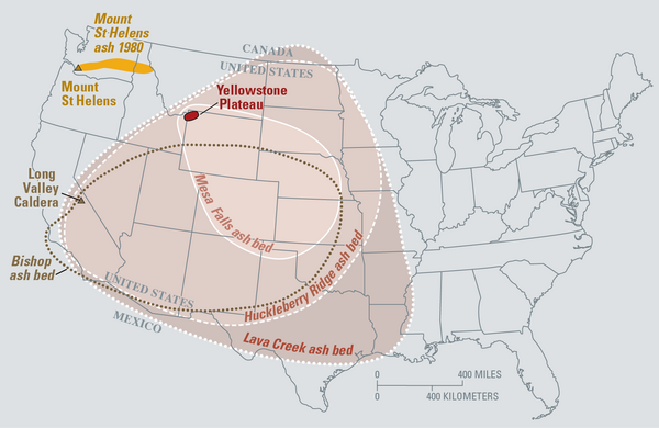
Eruptions of the Yellowstone volcanic system have included the two largest volcanic eruptions in North America in the past few million years; the third largest was at Long Valley in California and produced the Bishop ash bed. The biggest of the Yellowstone eruptions occurred 2.1 million years ago, depositing the Huckleberry Ridge ash bed.
Eruptions of the Yellowstone volcanic system have included the two largest volcanic eruptions in North America in the past few million years; the third largest was at Long Valley in California and produced the Bishop ash bed. The biggest of the Yellowstone eruptions occurred 2.1 million years ago, depositing the Huckleberry Ridge ash bed.

USGS Debris-flow flume near Blue River, Oregon is used to conduct debris flows and landslide experiments. Flume is a reinforced concrete channel 95 m (310 ft long, 2 m (6.6 ft) wide, and 1.2 m (4 ft).
USGS Debris-flow flume near Blue River, Oregon is used to conduct debris flows and landslide experiments. Flume is a reinforced concrete channel 95 m (310 ft long, 2 m (6.6 ft) wide, and 1.2 m (4 ft).

Crater Lake is the remnant of Mount Mazama, which erupted catastrophically 7,700 years ago to form the caldera.Wizard Island in lake and Mount Scott is peak on right shore. View from south. Oregon
Crater Lake is the remnant of Mount Mazama, which erupted catastrophically 7,700 years ago to form the caldera.Wizard Island in lake and Mount Scott is peak on right shore. View from south. Oregon