
During the USGS Hawaiian Volcano Observatory reconnaissance overflight the morning of September 19, geologists observed the fissure west of Nāpau Crater generating a lava flow that travels northeast before cascading into the crater on the remote middle East Rift Zone of Kīlauea. This aerial view is looking in a south direction, from north of the eruption site.
Multimedia
Webcams—Near-real-time images from webcams.
Videos—Collection of videos recorded during field excursions or caught on our webcams.
Image Galleries—Galleries of images and events with expanded descriptions.
The Kīlauea Photo and Video Chronology and Mauna Loa Photo and Video Chronology webpages also feature photos.
Images

September 19, 2024 —Kīlauea middle East Rift Zone eruption overflight
During the USGS Hawaiian Volcano Observatory reconnaissance overflight the morning of September 19, geologists observed the fissure west of Nāpau Crater generating a lava flow that travels northeast before cascading into the crater on the remote middle East Rift Zone of Kīlauea. This aerial view is looking in a south direction, from north of the eruption site.

September 19, 2024 —Kīlauea middle East Rift Zone eruption overflight
The 150-m-long (nearly 500 feet) fissure erupting west of Nāpau Crater within Hawaʻi Volcanoes National Park began erupting yesterday, September 18, around 3:15 p.m. It's part of an eruptive sequence that began in this area the night of September 15, 2024.
The 150-m-long (nearly 500 feet) fissure erupting west of Nāpau Crater within Hawaʻi Volcanoes National Park began erupting yesterday, September 18, around 3:15 p.m. It's part of an eruptive sequence that began in this area the night of September 15, 2024.

September 19, 2024 —Kīlauea middle East Rift Zone eruption aerial views
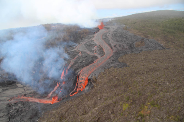
USGS Hawaiian Volcano Observatory geologists conducted a reconnaissance overflight of the eruption near Nāpau Crater on the middle East Rift Zone of Kīlauea. They observed a 150-m-long (nearly 500 feet) fissure west of the crater erupting lava that is flowing in the crater via a channel more than 50 meters (about 164 feet) wide.
USGS Hawaiian Volcano Observatory geologists conducted a reconnaissance overflight of the eruption near Nāpau Crater on the middle East Rift Zone of Kīlauea. They observed a 150-m-long (nearly 500 feet) fissure west of the crater erupting lava that is flowing in the crater via a channel more than 50 meters (about 164 feet) wide.

September 19, 2024 —Kīlauea middle East Rift Zone eruption overflight
USGS Hawaiian Volcano Observatory geologists conducted a reconnaissance overflight of the eruption near Nāpau Crater on the middle East Rift Zone of Kīlauea. They observed a 150-m-long (nearly 500 feet) fissure west of the crater erupting lava that is flowing in the crater via a channel more than 50 meters (about 164 feet) wide.
USGS Hawaiian Volcano Observatory geologists conducted a reconnaissance overflight of the eruption near Nāpau Crater on the middle East Rift Zone of Kīlauea. They observed a 150-m-long (nearly 500 feet) fissure west of the crater erupting lava that is flowing in the crater via a channel more than 50 meters (about 164 feet) wide.
September 19, 2024 —Kīlauea middle East Rift Zone eruption overflight
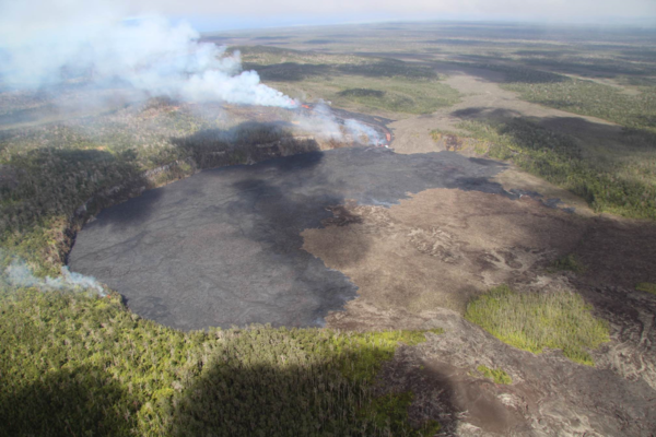
USGS Hawaiian Volcano Observatory geologists conducted a reconnaissance overflight of the eruption near Nāpau Crater on the middle East Rift Zone of Kīlauea. New lava from fissure eruptions over the past several days now covers about two thirds of the crater floor. USGS photo by M. Zoeller.
USGS Hawaiian Volcano Observatory geologists conducted a reconnaissance overflight of the eruption near Nāpau Crater on the middle East Rift Zone of Kīlauea. New lava from fissure eruptions over the past several days now covers about two thirds of the crater floor. USGS photo by M. Zoeller.
September 19, 2024 —Kīlauea middle East Rift Zone eruption overflight
USGS Hawaiian Volcano Observatory geologists conducted a reconnaissance overflight of the eruption near Nāpau Crater on the middle East Rift Zone of Kīlauea. They observed lava cascading over the rim of the crater from a channel more than 50 meters (about 164 feet) wide. Lava is contained within Nāpau Crater and now covers about two thirds of the crater floor.
USGS Hawaiian Volcano Observatory geologists conducted a reconnaissance overflight of the eruption near Nāpau Crater on the middle East Rift Zone of Kīlauea. They observed lava cascading over the rim of the crater from a channel more than 50 meters (about 164 feet) wide. Lava is contained within Nāpau Crater and now covers about two thirds of the crater floor.
Videos
September 19, 2024 — Kīlauea middle East Rift Zone eruption overflight
USGS Hawaiian Volcano Observatory geologists conducted a reconnaissance overflight of the eruption near Nāpau Crater on the middle East Rift Zone of Kīlauea. They observed lava cascading over the rim of the crater from a channel more than 50 meters (about 164 feet) wide. Lava is contained within Nāpau Crater and now covers about two thirds of the crater floor.
USGS Hawaiian Volcano Observatory geologists conducted a reconnaissance overflight of the eruption near Nāpau Crater on the middle East Rift Zone of Kīlauea. They observed lava cascading over the rim of the crater from a channel more than 50 meters (about 164 feet) wide. Lava is contained within Nāpau Crater and now covers about two thirds of the crater floor.

September 19, 2024 —Kīlauea lava fountains erupting
On September 19, USGS Hawaiian Volcano Observatory geologists were able to capture this video of the fissure vent eruption west of Nāpau Crater on the middle East Rift Zone of Kīlauea. They observed a 150-m-long (nearly 500 feet) fissure west of the crater erupting lava in a curtain of lava 10-20 meters (33-66 feet) high. USGS video by M. Zoeller.
On September 19, USGS Hawaiian Volcano Observatory geologists were able to capture this video of the fissure vent eruption west of Nāpau Crater on the middle East Rift Zone of Kīlauea. They observed a 150-m-long (nearly 500 feet) fissure west of the crater erupting lava in a curtain of lava 10-20 meters (33-66 feet) high. USGS video by M. Zoeller.

September 17, 2024 —Kīlauea middle East Rift Zone eruption overflight
Kīlauea volcano is erupting in Hawai’i Volcanoes National Park from a new fissure vent that opened within Nāpau Crater this morning, September 17, between 4:00 and 5:00 AM HST. The eruption is occurring within a closed and remote area of Hawaiʻi Volcanoes National Park.
Kīlauea volcano is erupting in Hawai’i Volcanoes National Park from a new fissure vent that opened within Nāpau Crater this morning, September 17, between 4:00 and 5:00 AM HST. The eruption is occurring within a closed and remote area of Hawaiʻi Volcanoes National Park.

September 17, 2024 —Kīlauea middle East Rift Zone eruption sampling
USGS Hawaiian Volcano Observatory geologists collected a sample of the middle East Rift Zone Kīlauea eruption in Nāpau Crater, within a closed area Hawaiʻi Volcanoes National Park. Geologists put molten lava into a metal bucket and rapidly quench it with water.
USGS Hawaiian Volcano Observatory geologists collected a sample of the middle East Rift Zone Kīlauea eruption in Nāpau Crater, within a closed area Hawaiʻi Volcanoes National Park. Geologists put molten lava into a metal bucket and rapidly quench it with water.

September 16, 2024—Brief eruption near Nāpau Crater on Kīlauea Middle East Rift Zone
During a USGS Hawaiian Volcano Observatory overflight at approximately 10:30 a.m. HST on September 16, geologists observed freshly erupted lava west of Nāpau Crater on the remote middle East Rift Zone of Kīlauea, within Hawaiʻi Volcanoes National Park. This eruption likely occurred between approximately 9–10 p.m. HST on September 15. USGS video by M.
During a USGS Hawaiian Volcano Observatory overflight at approximately 10:30 a.m. HST on September 16, geologists observed freshly erupted lava west of Nāpau Crater on the remote middle East Rift Zone of Kīlauea, within Hawaiʻi Volcanoes National Park. This eruption likely occurred between approximately 9–10 p.m. HST on September 15. USGS video by M.

September 16, 2024 —Kīlauea middle East Rift Zone eruption overflight
This video, taken during a Hawaiian Volcano Observatory morning overflight of Kīlaueaʻs middle East Rift Zone on September 16, 2024, shows new lava flows erupted over about an hour during the evening on September 15, 2024.
This video, taken during a Hawaiian Volcano Observatory morning overflight of Kīlaueaʻs middle East Rift Zone on September 16, 2024, shows new lava flows erupted over about an hour during the evening on September 15, 2024.
Audio

Lava lake activity from inside Halema`uma`u Crater
Sounds of lava lake activity within Kilauea Volcano's summit vent inside Halema`uma`u Crater on the afternoon of February 14, 2011. The continuous "crashing wave" noise is the sound of churning lava as gases are released from the lake surface, which is in nearly constant motion.
Sounds of lava lake activity within Kilauea Volcano's summit vent inside Halema`uma`u Crater on the afternoon of February 14, 2011. The continuous "crashing wave" noise is the sound of churning lava as gases are released from the lake surface, which is in nearly constant motion.

Dramatic Developments at Kilauea Volcano
Kilauea Volcano in Hawaii has experienced its first explosive eruption in more than 80 years and is now spewing noxious gas at 10 times the normal rate. John Eichelberger, head of the USGS Volcano Hazards Program, fills us in on the situation.
Kilauea Volcano in Hawaii has experienced its first explosive eruption in more than 80 years and is now spewing noxious gas at 10 times the normal rate. John Eichelberger, head of the USGS Volcano Hazards Program, fills us in on the situation.
Webcams
[S2cam] - View of Nāpau Crater on the East Rift Zone of Kīlauea, view is to the southwest
Live view of Nāpau Crater on the East Rift Zone of Kīlauea, view is to the southwest [S2cam].
Disclaimer
Live view of Nāpau Crater on the East Rift Zone of Kīlauea, view is to the southwest [S2cam].
Disclaimer

[KOcam] Live Image of upper East Rift Zone from Maunaulu
This image is from a temporary research camera positioned near Maunaulu, looking northwest toward the upper East Rift Zone of Kīlauea.
Disclaimer
This image is from a temporary research camera positioned near Maunaulu, looking northwest toward the upper East Rift Zone of Kīlauea.
Disclaimer

[MDLcam] The Upper and Middle Parts of Mauna Loa's Southwest Rift Zone
Live image of Mauna Loa's upper and middle Southwest Rift Zone from Dandelion Cone along the middle part of the rift zone [MDLcam]. This camera is a pan-tilt-zoom model and the view may change depending on activity.
Disclaimer
Live image of Mauna Loa's upper and middle Southwest Rift Zone from Dandelion Cone along the middle part of the rift zone [MDLcam]. This camera is a pan-tilt-zoom model and the view may change depending on activity.
Disclaimer

[MSPcam] Mauna Loa's Southwest Rift Zone from the South Point area
Live image of Mauna Loa's Southwest Rift Zone from the South Point area [MSPcam]. This camera is a pan-tilt-zoom model and the view may change depending on activity.
Disclaimer
Live image of Mauna Loa's Southwest Rift Zone from the South Point area [MSPcam]. This camera is a pan-tilt-zoom model and the view may change depending on activity.
Disclaimer
[MITDcam] Kīlauea upper Southwest Rift Zone
[MITDcam] Live view of Kīlauea's upper Southwest Rift Zone, looking northwest from a seismic station in the Kaʻū Desert.
[MITDcam] Live view of Kīlauea's upper Southwest Rift Zone, looking northwest from a seismic station in the Kaʻū Desert.

[B2cam] Halemaʻumaʻu crater from the east rim and down-dropped block
[B2cam] This image is from a research camera located on the down-dropped block in Kīlauea caldera and east rim of Halemaʻumaʻu crater within Hawaiʻi Volcanoes National Park. The camera is looking west towards Halemaʻumaʻu crater.
Disclaimer
[B2cam] This image is from a research camera located on the down-dropped block in Kīlauea caldera and east rim of Halemaʻumaʻu crater within Hawaiʻi Volcanoes National Park. The camera is looking west towards Halemaʻumaʻu crater.
Disclaimer