
Frequently Asked Questions earthquakes and volcanoes in American Samoa
Questions about American Samoa volcanoes and the earthquakes that were felt in eastern American Samoa from July–September 2022.
What happened in American Samoa in 2022?
The earliest report of a felt earthquake was on July 26, 2022, from Ta‘ū Island. By August 6, the earthquakes were reported felt by residents of all the Manu‘a Islands (Ofu-Olosega and Ta‘ū). On August 23 one of these earthquakes was large enough to be felt on Tutuila Island, which is about 60 miles (100 km) west of the Manuʻa Islands.
The exact number of earthquakes is unknown. At the height of activity in late August 2022, approximately 20–60 earthquakes per hour were occurring.
Most earthquakes were too small to be felt, but at the height of the swarm in late August, around 30 earthquakes per day were large enough to be felt. The largest earthquakes were estimated to be between magnitude 2 and 3.5. A widely felt earthquake at 8:33 p.m. Samoa Standard Time on August 23 was one of the largest earthquakes recorded during the activity. Its magnitude was likely 3–3.5 or larger.
Why were earthquakes felt in American Samoa in 2022?
This type of activity is called an earthquake swarm because many earthquakes of about the same size repeatedly occur in generally the same area.
Earthquake swarms happen for many reasons – they can occur as the earth’s crust settles in response to tectonic plate movement, when the earth’s crust adjusts to having a significant weight (a volcano) on top of it, or when magma or other fluids move and fracture rock beneath the ground surface. Because the earthquakes did not move, we can say that the mechanism causing them isn’t moving through the earth. However, we are not completely certain why these events occurred.
Where were the earthquakes located in the American Samoa 2022 earthquake swarm?
Preliminary data analysis suggests a wide area of possible earthquake locations extending from deep beneath the northern shore of Ta‘ū Island to shallower depths about 20 km (13 mi) to the north. Seismologists determined that earthquakes occurred in a fixed position within the earth. So, although there was difficulty in resolving the exact location within the earth, the earthquakes did not move from that spot.
Why is it difficult to locate earthquakes in American Samoa?
For ideal earthquake monitoring at volcanoes, an array of a minimum of three seismometers would surround the earthquake location to better "see" the earthquake source from different angles. This array design allows seismologists to better resolve the latitude, longitude, and depth of earthquakes that are occurring around the volcano. Because of the geometry of the islands in American Samoa, seismometers have been installed in a relatively straight east-west line. This limits the ability to resolve the depth and north-south locations of the earthquakes, whereas the east-west locations are well resolved.
Why are there volcanoes in American Samoa, and how often do they erupt?

The islands that form American Samoa are the exposed tops of volcanoes, most of which are hidden beneath the ocean surface. Volcanoes in American Samoa form as the Pacific Plate moves northwest over the Samoan hotspot. A hotspot is an area where magma (molten rock beneath the ground surface) rises from the Earth’s mantle to form volcanoes. Currently, the center of the Samoan hotspot is thought to be close to the Vailulu‘u seamount, located about 25 miles (45 kilometers) east of Ta‘ū Island.
Vailulu‘u has erupted several times in the past 50 years, but volcanoes that form the islands of Ofu-Olosega and Ta‘ū have only one documented eruption over the past 200 years. This eruption was in 1866, between Ofu-Olosega and Ta‘ū Islands. Though this eruption happened approximately 2 miles (3 km) southeast of Olosega and stopped before the cone emerged above the ocean surface, it did impact residents. Earthquakes were felt before, and during the eruption, volcanic gases released during the eruption caused air (vog) and ocean pollution (inferred from dead fish), and tephra (small volcanic particles) was blown downwind.
What is the USGS doing to better understand volcanoes in American Samoa?
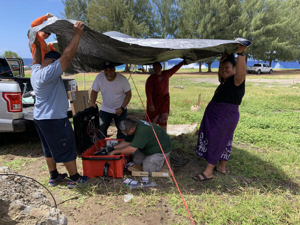
The U.S. Geological Survey Hawaiian Volcano Observatory (USGS HVO) is responsible for monitoring volcanoes in American Samoa. Before August 2022, there was no volcano-monitoring equipment on the ground in American Samoa. Once USGS HVO found out about the earthquakes, staff were sent to American Samoa to meet with local authorities and residents and install monitoring equipment.

USGS HVO staff arrived in American Samoa on August 11, and the first micro-seismometer (small earthquake-detecting device) was installed on Ta‘ū Island on August 13 with the help of the National Oceanic And Atmospheric Administration (NOAA) National Weather Service Pago Pago office. By August 24, six microseismometers and three broadband seismometers (the standard for volcano monitoring) were installed across American Samoa. A fourth broadband seismometer was installed on September 14. Data collected by seismometers helps us understand where earthquakes occur and what processes might be causing them, and most importantly, to track changes in the location, rate, and size of earthquakes. Changes in any of those characteristics are essential to detect as they may indicate a change in hazards.
In early September 2022, two Global Positioning System (GPS) receivers were installed. The GPS equipment detects very slight movements (less than an inch!) of the ground.
Satellite remote sensing is another tool the USGS has been using since the middle of August 2022. Satellites can detect heat, volcanic gas, and volcanic ash associated with early phases of volcanic activity.

How long do earthquake swarms last?
It can vary wildly and depends upon the tectonic and volcanic settings. Swarms that include earthquakes that don’t move within the earth can be very short-lived with seismicity lasting only a few hours to days—this happens often at large volcanic systems like Long Valley Caldera and Yellowstone. There was an episode like that in the Azores volcanic islands off the coast of Portugal) earlier in 2022. But in other situations, earthquake swarms can last for months or years. A swarm on the eastern border of Northern Nevada began in July 2014 and kept going at a declining rate into early 2017; called the “Antelope Swarm,” there is no consensus on a cause for the earthquakes, but the area is capable of producing volcanic eruptions. Before the eruption in Iceland in 2021, there were at least months of seismicity and ground deformation. Some volcanoes have "personalities" and so have a tendency towards one style versus another, but we know relatively little about the volcanoes of American Samoa, and they don't erupt above the water or in shallow water that often (most recently in 1866). Experience with these volcanoes is therefore limited.
What caused the earthquakes in American Samoa in 2022 and what volcanic hazards could impact American Samoa Islands?

Most earthquake swarms on volcanoes do not result in an eruption. However, earthquake swarms can precede volcanic activity, such as an intrusion (magma moving within a volcano but not reaching the surface) or an eruption (magma moves within a volcano and reaches the surface). There is a chance the earthquakes in American Samoa during 2022 were caused by volcanic activity, but an eruption like Hunga Tonga–Hunga Ha'apai in Tonga in 2021 is extremely unlikely in American Samoa. This is because hot spot shield volcanoes like Ta‘ū Island have less explosive eruptions than a volcano like Hunga Tonga-Hunga Ha'apai.
If future earthquake swarms occur in America Samoa and lead to a volcanic eruption, the type of eruption and its hazards will largely depend on the eruption location. Eruptions do not always come from the top of the volcano, and there is evidence that past eruptions have happened in many different places on Ta‘ū Volcano. Most of Ta‘ū Volcano is underwater.
If an eruption occurs in deep ocean water (hundreds of yards deep), it will be mostly confined by the sea water. People may see discolored water, and they may be bursts of steam or volcanic ash from the water. If an eruption happens on land in an area with little ground water, it will produce low-level explosions of lava particles confined to an area near the eruption site. Such on-land “dry” eruptions can also feed long lava flows that move downhill. The worst-case scenario would be for an eruption to occur near the coast. This could produce large explosions of rock, volcanic ash, and steam. Hazards from a coastal eruption would be wide-reaching—hot, ground-hugging surges of steam and ash might accompany the high-velocity ejection of heavy rocks. These eruptions can produce high plumes of volcanic ash that travel far distances downwind. Secondary hazards from a coastal eruption include local tsunamis.
Any possible eruption could last days to years. The Ofu-Olosega submarine eruption in 1866 lasted a few months.
To learn about the types of eruptions possible in American Samoa and the associated hazards, see this webpage: https://www.usgs.gov/observatories/hvo/volcanic-eruptions-and-hazards-american-samoa
What should I do to protect myself and my family now and if there is an eruption in American Samoa?
Become aware of the volcanic hazards that might affect the areas where you live, work, or visit. Know who the trusted sources of information are. Make an emergency kit. Plan what to do during an emergency, such as an evacuation, by identifying responsibilities for each household member to work together as a team.
To learn about the types of eruptions possible in American Samoa and the associated hazards, see this webpage: https://www.usgs.gov/observatories/hvo/volcanic-eruptions-and-hazards-american-samoa
Trusted sources of information on unrest in American Samoa:
-
Hawaiian Volcano Observatory: https://www.usgs.gov/observatories/hvo
-
National Weather Service Pago Pago Office: https://www.weather.gov/ppg/wsopagooffice
-
Pacific Tsunami Warning Center: https://tsunami.gov/
-
American Samoa Department of Homeland Security: https://www.americansamoa.gov/dhs
Information on how to build an emergency kit:
-
“Go Bag” checklist from Hawaii Emergency Management Agency: http://dod.hawaii.gov/hiema/files/2016/03/GoBagFlyer.pdf
-
American Red Cross Emergency Kit Suggestions: https://www.redcross.org/about-us/news-and-events/news/2019/national-pr…;
Information on how to build an emergency plan:
-
Making a Family Emergency Plan website: http://dod.hawaii.gov/hiema/get-ready/prepare-your-family/ (State of Hawaii, Hawaii Emergency Management Agency)
-
Emergency plan template: http://dod.hawaii.gov/hiema/files/2020/02/20200228-Emergency_Plan_bw.pdf (State of Hawaii, Hawaii Emergency Management Agency)
-
Family disaster plan template: https://www.piercecountywa.gov/DocumentCenter/View/23518/ARC_Family_Dis… (American Red Cross)
How can I stay informed about volcanoes in American Samoa?

HVO issues notices about volcanoes in American Samoa via the USGS Volcano Notification Service (VNS). This free service sends notices via email about volcanic activity in the US.
To receive Volcano Activity Notices (VANs), subscribe to the VNS at https://volcanoes.usgs.gov/vns2/. For emails about American Samoa unrest, select Ofu-Olosega, Ta’ū Island, and Tutuila Island from the list of available volcanoes. Alternatively, select “Hawaiian Volcano Observatory - Add All Volcanoes” from the list of available volcano observatories to receive notices about volcanoes in Hawaii and American Samoa.
For more information about the different types of VNS notifications, please see: https://volcanoes.usgs.gov/vhp/notifications.html
Other resources:
-
Hawaiian Volcano Observatory website: https://www.usgs.gov/observatories/hvo
-
Volcanoes in American Samoa website: https://www.usgs.gov/observatories/hvo/volcanoes-american-samoa
-
Taʻū Island volcano website: https://www.usgs.gov/volcanoes/ta-u-island
-
National Weather Service Pago Pago Office: https://www.weather.gov/ppg/wsopagooffice
-
Pacific Tsunami Warning Center: https://tsunami.gov/
-
International Tsunami Information Center and American Samoa Tsunami Awareness Information: http://www.tsunamiwave.org
How can I report observations about volcanoes in American Samoa?
Residents can assist volcano monitoring efforts by noting and reporting accurate times that they feel earthquake shaking or notice other changes (smells like rotten eggs, dead fish, areas with dead vegetation, ground cracks, and generally unusual activity) that might be related to volcanic activity to either the Pago Pago National Weather Service Office (https://www.weather.gov/ppg/wsopagooffice) or the American Samoa EOC in Pago Pago (684-699-3800).