



Near the coast, the northern margin of the lava flow field is still oozing fresh lava at several points in the area of Kapoho Beach Lots. Smoke marks locations where lava is burning vegetation.
Images
Hawaiian Volcano Observatory images of eruptive activity, field work, and more.
Filter Total Items: 4165

Kīlauea Volcano — Fresh Lava at Kapoho Beach Lots
Near the coast, the northern margin of the lava flow field is still oozing fresh lava at several points in the area of Kapoho Beach Lots. Smoke marks locations where lava is burning vegetation.

routine inspection of a UAS system prior to a flight
routine inspection of a UAS system prior to a flightTwo U.S. Geological Survey Unmanned Aircraft Systems (UAS) pilots perform a routine inspection of a UAS system prior to a flight at the summit of Kīlauea Volcano in June 2018. The UAS for this particular flight was outfitted with a multi-gas sensor to identify any new degassing sources within the collapsing summit caldera.
routine inspection of a UAS system prior to a flight
routine inspection of a UAS system prior to a flightTwo U.S. Geological Survey Unmanned Aircraft Systems (UAS) pilots perform a routine inspection of a UAS system prior to a flight at the summit of Kīlauea Volcano in June 2018. The UAS for this particular flight was outfitted with a multi-gas sensor to identify any new degassing sources within the collapsing summit caldera.

Kīlauea Volcano — Fissure 8 Lava Channel
Continued eruption at Fissure 8 feeds the voluminous lava channel to the ocean as seen during this morning's overflight of the lava-flow field.
Continued eruption at Fissure 8 feeds the voluminous lava channel to the ocean as seen during this morning's overflight of the lava-flow field.

Kīlauea Volcano — Channel Overflow
A small overflow from the lava channel (left side of image) captured by an Unmanned Aircraft System (UAS). Small overflows on both sides of the channel occurred shortly after midnight in the uppermost part of channel. None of these overflows extended past the existing flow field.
A small overflow from the lava channel (left side of image) captured by an Unmanned Aircraft System (UAS). Small overflows on both sides of the channel occurred shortly after midnight in the uppermost part of channel. None of these overflows extended past the existing flow field.

Kīlauea Volcano — Kapoho Coastline Ocean Entries
Lava continues to enter the sea along the southern Kapoho coastline. Lava enters the ocean primarily through an open channel, but also along a 1-km (0.6 mi) wide area. Also visible in the image (center right) is an area at the northern margin of the flow field that is oozing fresh lava at several points in the area of Kapoho Beach Lots.
Lava continues to enter the sea along the southern Kapoho coastline. Lava enters the ocean primarily through an open channel, but also along a 1-km (0.6 mi) wide area. Also visible in the image (center right) is an area at the northern margin of the flow field that is oozing fresh lava at several points in the area of Kapoho Beach Lots.

Kīlauea Volcano — Overflows
Overflows from the perched lava channel are seen as incandescent (glowing) fingers moving down the sides of the channel (left side of photo). Fissure 8 lava fountain in photo center.
Overflows from the perched lava channel are seen as incandescent (glowing) fingers moving down the sides of the channel (left side of photo). Fissure 8 lava fountain in photo center.

Kīlauea Volcano — Laze Plumes
Lava from fissure 8 is entering the sea this morning on the southern portion of the flow front primarily through the open channel, but also along this 1 km (0.6 mi) wide area with multiple laze plumes from smaller oozing lobes.
Lava from fissure 8 is entering the sea this morning on the southern portion of the flow front primarily through the open channel, but also along this 1 km (0.6 mi) wide area with multiple laze plumes from smaller oozing lobes.

Kīlauea Summit UAS footage shows an ever growing Halema‘uma‘u
Kīlauea Summit UAS footage shows an ever growing Halema‘uma‘uA UAS mission on June 24, 2018, filmed details of the dramatic changes occurring within Halema‘uma‘u crater at Kīlauea's summit since explosive eruptions of ash and gas and ongoing wall collapse began in mid-May. Clearly visible are the steep crater walls that continue to slump inward and downward with ongoing subsidence at Kīlauea's summit.
Kīlauea Summit UAS footage shows an ever growing Halema‘uma‘u
Kīlauea Summit UAS footage shows an ever growing Halema‘uma‘uA UAS mission on June 24, 2018, filmed details of the dramatic changes occurring within Halema‘uma‘u crater at Kīlauea's summit since explosive eruptions of ash and gas and ongoing wall collapse began in mid-May. Clearly visible are the steep crater walls that continue to slump inward and downward with ongoing subsidence at Kīlauea's summit.

Kīlauea Volcano — Lava Channel Branches Off
Southward facing view of the point at which the fissure 8 lava channel bifurcates.
Southward facing view of the point at which the fissure 8 lava channel bifurcates.

Kīlauea Volcano — Ocean Entry
North facing view of the 1 km (0.6 mi) long ocean entry with multiple lobes of lava flowing into the sea.
North facing view of the 1 km (0.6 mi) long ocean entry with multiple lobes of lava flowing into the sea.

Kīlauea Volcano — Remobilized Ash Plume
Recent explosive events haven't produced significant ash plumes from the summit, but downwind communities may still experience ashfall when previously erupted ash is remobilized. On authorized permission from Hawai‘i Volcanoes National Park, our Unmanned Aircraft Systems crew is conducting gas measurements at Pu‘u ‘Ō‘ō.
Recent explosive events haven't produced significant ash plumes from the summit, but downwind communities may still experience ashfall when previously erupted ash is remobilized. On authorized permission from Hawai‘i Volcanoes National Park, our Unmanned Aircraft Systems crew is conducting gas measurements at Pu‘u ‘Ō‘ō.

Kīlauea Volcano —
Comparison of photographs taken on June 13 and 26 from near Keanakāko'i Crater overlook in Hawai'i Volcanoes National Park shows a subsidence scarp that formed as the Kīlauea Crater floor subsided. Scientists estimate the dramatic dropping of the crater floor in this area occurred sometime between June 23 and 26. The view is to the west.
Comparison of photographs taken on June 13 and 26 from near Keanakāko'i Crater overlook in Hawai'i Volcanoes National Park shows a subsidence scarp that formed as the Kīlauea Crater floor subsided. Scientists estimate the dramatic dropping of the crater floor in this area occurred sometime between June 23 and 26. The view is to the west.

Kīlauea Volcano — Braided Lava Channels
Lava within the braided portion of the fissure 8 channel is flowing within its banks. View looking downstream toward the sunrise over the ocean entry.
Lava within the braided portion of the fissure 8 channel is flowing within its banks. View looking downstream toward the sunrise over the ocean entry.

Kīlauea Volcano — Webcam Plume
At 10:41 p.m.

Kīlauea Volcano — Documenting Fissure 8 Activity
USGS Hawaiian Volcano Observatory geology field crews maintain watch over the eruptive activity in the lower East Rift Zone and at Kīlauea's summit. Here, a geologist documents the behavior of lava as it exits the Fissure 8 cone. Lava enters the upper channel traveling as fast as 30 km/hour (18 mi/hour).
USGS Hawaiian Volcano Observatory geology field crews maintain watch over the eruptive activity in the lower East Rift Zone and at Kīlauea's summit. Here, a geologist documents the behavior of lava as it exits the Fissure 8 cone. Lava enters the upper channel traveling as fast as 30 km/hour (18 mi/hour).

Kīlauea Volcano — Fissure 8 From Luana Street
View of the fissure 8 cone and fountain from the end of Luana Street in Leilani Estates. Photo taken at 12:20 p.m.
View of the fissure 8 cone and fountain from the end of Luana Street in Leilani Estates. Photo taken at 12:20 p.m.
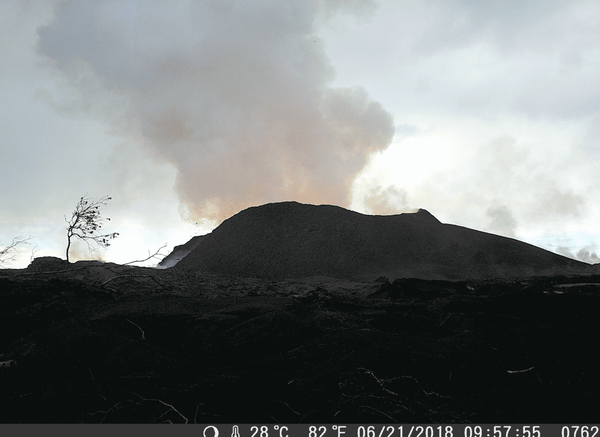
Kīlauea Volcano — Fissure 8 Cone Changes (GIF)

Kīlauea Volcano — Sunrise Over Lava Channel
Early morning view of the open lava channel during helicopter overflight of the lower East Rift Zone.
Early morning view of the open lava channel during helicopter overflight of the lower East Rift Zone.

Kīlauea Volcano — Halema`uma`u Panoramic
This panorama of Kīlauea's summit caldera was made about 10 a.m. HST from the Keanakāko‘i overlook on the south side of the caldera. Halema‘uma‘u is visible steaming to the left, and the ongoing ground cracking is visible in the center of the image.
This panorama of Kīlauea's summit caldera was made about 10 a.m. HST from the Keanakāko‘i overlook on the south side of the caldera. Halema‘uma‘u is visible steaming to the left, and the ongoing ground cracking is visible in the center of the image.

Kīlauea Volcano — Lava Flows from Fissure 8
View to the southwest, looking "up" the lava channel. Lava flows from Fissure 8 (not pictured) through the open channel about 13 km (8 mi) to the ocean. Lava remains incandescent (glowing orange) along the entire length of the channel with sections of cooled lava (black) on the surface.
View to the southwest, looking "up" the lava channel. Lava flows from Fissure 8 (not pictured) through the open channel about 13 km (8 mi) to the ocean. Lava remains incandescent (glowing orange) along the entire length of the channel with sections of cooled lava (black) on the surface.

Kīlauea Volcano — Fissure 8 Fountain
At fissure 8, fountains provide a vigorous supply of lava that exits the cinder cone and drops over a spillway to enter a well-established lava channel that extends to the sea.
At fissure 8, fountains provide a vigorous supply of lava that exits the cinder cone and drops over a spillway to enter a well-established lava channel that extends to the sea.