
Fissure 8 cone, lava fountain, and channelized lava flow on the morning overflight - June 19 at about 6:10am HST. The lava channel is very full with many small overflows visible on the channel margins. Overflows are sluggish and move slowly downslope as they build up the levees.
Images
Hawaiian Volcano Observatory images of eruptive activity, field work, and more.
Filter Total Items: 4072

Kīlauea Volcano — Fissure 8 Lava Channel
Fissure 8 cone, lava fountain, and channelized lava flow on the morning overflight - June 19 at about 6:10am HST. The lava channel is very full with many small overflows visible on the channel margins. Overflows are sluggish and move slowly downslope as they build up the levees.

Kīlauea LERZ lava flows and fissures, June 19, 1:00 p.m.
Kīlauea LERZ lava flows and fissures, June 19, 1:00 p.m.Map as of 1:00 p.m. HST, June 19, 2018. Given the dynamic nature of Kīlauea's lower East Rift Zone eruption, with changing vent locations, fissures starting and stopping, and varying rates of lava effusion, map details shown here are accurate as of the date/time noted. Shaded purple areas indicate lava flows erupted in 1840, 1955, 1960, and 2014-2015.

Kīlauea Volcano — Fissure 8 Eruption (June 18-19, 2018)
Kīlauea Volcano — Fissure 8 Eruption (June 18-19, 2018)Fissure 8 vigor increased overnight June 18-19 with lava fountains reaching up to 60 m (200 ft). Spatter built up the cone to the east and into the channel.
Kīlauea Volcano — Fissure 8 Eruption (June 18-19, 2018)
Kīlauea Volcano — Fissure 8 Eruption (June 18-19, 2018)Fissure 8 vigor increased overnight June 18-19 with lava fountains reaching up to 60 m (200 ft). Spatter built up the cone to the east and into the channel.

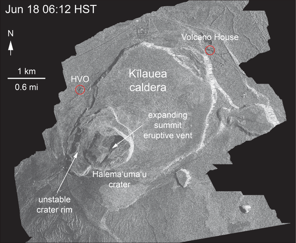
Kīlauea Volcano — Halema‘uma‘u Crater Slumping
An overflight of Kīlauea's summit on June 18 showed the continued dramatic slumping and collapse of the Halema‘uma‘u crater area. This photo shows the area north-northwest of Halema‘uma‘u near a GPS station, North Pit. This station has subsided about 60 m (197 ft) in the past week.
An overflight of Kīlauea's summit on June 18 showed the continued dramatic slumping and collapse of the Halema‘uma‘u crater area. This photo shows the area north-northwest of Halema‘uma‘u near a GPS station, North Pit. This station has subsided about 60 m (197 ft) in the past week.

Kīlauea Volcano — Fissure 8 Lava Channels

Kīlauea Volcano — Fissure 6
Fissure 6 (photo center) showed signs of activity overnight, producing small amounts of spatter and feeding short lava flows. Fissure 6 is located about 2.2 km (1.4 mi) downrift from Fissure 8.
Fissure 6 (photo center) showed signs of activity overnight, producing small amounts of spatter and feeding short lava flows. Fissure 6 is located about 2.2 km (1.4 mi) downrift from Fissure 8.

Kīlauea Volcano — Halema`uma`u Crater (with HVO)
During the helicopter overflight on June 18, crews captured this image of the growing Halema‘uma‘u crater viewed to the southeast.
During the helicopter overflight on June 18, crews captured this image of the growing Halema‘uma‘u crater viewed to the southeast.

Kīlauea's LERZ
Fissure 8 lava flows in an open channel all the way to the ocean. Kapoho Crater is the vegetated hill on the right side of the photograph. Ocean entry plume seen in the distance.
Fissure 8 lava flows in an open channel all the way to the ocean. Kapoho Crater is the vegetated hill on the right side of the photograph. Ocean entry plume seen in the distance.
Kīlauea Volcano — Satellite Radar (Continued Slumping)
Kīlauea Volcano — Satellite Radar (Continued Slumping)This animated GIF shows a sequence of radar amplitude images that were acquired by the Agenzia Spaziale Italiana CosmoSkyMed satellite system. The images illustrate changes to the caldera area of Kīlauea Volcano that occurred between May 5 and June 18 at about 6:00 a.m. HST.

Kīlauea Volcano — Halema‘uma‘u Crater (June 18, 2018)
Kīlauea Volcano — Halema‘uma‘u Crater (June 18, 2018)Halema‘uma‘u viewed toward the west during the June 18 helicopter overflight. HVO and Jaggar Museum can barely be seen on the caldera rim in the upper right of the photograph.
Kīlauea Volcano — Halema‘uma‘u Crater (June 18, 2018)
Kīlauea Volcano — Halema‘uma‘u Crater (June 18, 2018)Halema‘uma‘u viewed toward the west during the June 18 helicopter overflight. HVO and Jaggar Museum can barely be seen on the caldera rim in the upper right of the photograph.
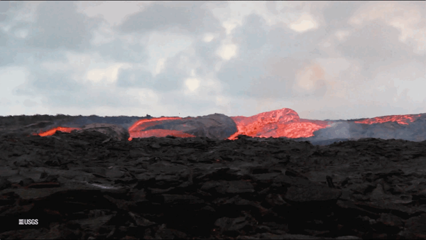
Kīlauea Volcano — Lava Flow (GIF)
An animated GIF showing lava bubbling out of fissure 8 at Kīlauea Volcano, Hawaii. Clip is taken from the full b-roll video listed as the source.
An animated GIF showing lava bubbling out of fissure 8 at Kīlauea Volcano, Hawaii. Clip is taken from the full b-roll video listed as the source.

Kīlauea Volcano — Fissure 8 Lava Flow
Fissure 8 cone and channelized lava flow.

Kīlauea Volcano —
Fissure 8 lava fountains obscured by a longer exposure photograph taken early morning on June 18. The incandescent spots along a horizontal line mark the edge of the lava channel.
Fissure 8 lava fountains obscured by a longer exposure photograph taken early morning on June 18. The incandescent spots along a horizontal line mark the edge of the lava channel.

Kīlauea Volcano — Thermal Camera Measurement
An HVO geologist uses a thermal camera to measure the temperature (about 93 degrees C or 200 degrees F) of a ground crack near fissure 9.
An HVO geologist uses a thermal camera to measure the temperature (about 93 degrees C or 200 degrees F) of a ground crack near fissure 9.

Kīlauea Volcano — Halema`uma`u Crater
North side of the growing Halema‘uma‘u crater, marked by large cracks and large blocks that have slumped into the crater.
North side of the growing Halema‘uma‘u crater, marked by large cracks and large blocks that have slumped into the crater.

Kīlauea LERZ lava flows and fissures, June 18, 9:00 a.m.
Kīlauea LERZ lava flows and fissures, June 18, 9:00 a.m.Map as of 9:00 a.m. HST, June 18, 2018. Given the dynamic nature of Kīlauea's lower East Rift Zone eruption, with changing vent locations, fissures starting and stopping, and varying rates of lava effusion, map details shown here are accurate as of the date/time noted. Shaded purple areas indicate lava flows erupted in 1840, 1955, 1960, and 2014-2015.

magma in a shallow reservoir beneath the summit drains into the East R
magma in a shallow reservoir beneath the summit drains into the East RAs magma in a shallow reservoir beneath the summit drains into the East Rift Zone, the ground above it sags, cracks and subsides. The Halema‘uma‘u crater has dropped about 400 m (1300 ft) between early May and late June. Inward slumping of the surrounding Kīlauea Crater floor has doubled the diameter of Halema‘uma‘u.

Geologist measures the height of the growing fissure 8 tephra cone
Geologist measures the height of the growing fissure 8 tephra coneA USGS Hawaiian Volcano Observatory geologist measures the height of the growing tephra cone around fissure 8 during Kīlauea Volcano's 2018 lower East Rift Zone eruption.

Kīlauea Volcano — Halema`uma`u Crater
Inward slumping of the rim and walls of Halema‘uma‘u continues in response to ongoing subsidence at the summit. Sulfur dioxide emissions from the volcano's summit have dropped to levels that are about half those measured prior to the onset of the current episode of eruptive activity.
Inward slumping of the rim and walls of Halema‘uma‘u continues in response to ongoing subsidence at the summit. Sulfur dioxide emissions from the volcano's summit have dropped to levels that are about half those measured prior to the onset of the current episode of eruptive activity.

Kīlauea Volcano — Fissure 8
Morning overflight of Kīlauea Volcano's lower East Rift Zone by the Civil Air Patrol provides context for the location of the fissure 8 fountain and lava channel within the lower Puna District.
Morning overflight of Kīlauea Volcano's lower East Rift Zone by the Civil Air Patrol provides context for the location of the fissure 8 fountain and lava channel within the lower Puna District.

Kīlauea Volcano — Lava Fountain
The fissure 8 lava fountain pulses to heights of 50 m (165 ft) within a cinder spatter cone. Fissure 8 feeds&nbs
The fissure 8 lava fountain pulses to heights of 50 m (165 ft) within a cinder spatter cone. Fissure 8 feeds&nbs