
How do you keep people safe when lava is rapidly advancing through communities? This was just one of the topics addressed during the Cities on Volcanoes 10 meeting in Naples, Italy, last week. Lava flows recently erupted from Kīlauea Volcano's lower East Rift Zone inundated hundreds of homes in the lower Puna District of Hawai‘i Island.
Images
Hawaiian Volcano Observatory images of eruptive activity, field work, and more.
Filter Total Items: 3998

lava is rapidly advancing through communities
How do you keep people safe when lava is rapidly advancing through communities? This was just one of the topics addressed during the Cities on Volcanoes 10 meeting in Naples, Italy, last week. Lava flows recently erupted from Kīlauea Volcano's lower East Rift Zone inundated hundreds of homes in the lower Puna District of Hawai‘i Island.

Kīlauea Volcano — Lower East Rift Zone
This view, looking south at Kīlauea's lower East Rift Zone, was captured during HVO's 6:00 a.m. HST helicopter overflight today.
This view, looking south at Kīlauea's lower East Rift Zone, was captured during HVO's 6:00 a.m. HST helicopter overflight today.

Kīlauea Volcano — Lava Delta at Kapoho Bay
This fish-eye view of the lava delta filling the former Kapoho Bay shows that while the delta margin nearest the ocean has cooled somewhat, the lava flow front is still very hot and producing laze (lava haze). Laze is a local hazard composed of acidic gases and volcanic glass fragments and should be avoided.
This fish-eye view of the lava delta filling the former Kapoho Bay shows that while the delta margin nearest the ocean has cooled somewhat, the lava flow front is still very hot and producing laze (lava haze). Laze is a local hazard composed of acidic gases and volcanic glass fragments and should be avoided.

Kīlauea Volcano — Kapoho Beach Lots
Views from HVO's helicopter overflight at 1PM HST, show the remains of the Kapoho Beach Lots subdivision and the fissure 8 flow front. The northern flow margin in this area was unchanged from HVO's morning flight and appeared to have stopped advancing at the time of the flight.
Views from HVO's helicopter overflight at 1PM HST, show the remains of the Kapoho Beach Lots subdivision and the fissure 8 flow front. The northern flow margin in this area was unchanged from HVO's morning flight and appeared to have stopped advancing at the time of the flight.


Kīlauea LERZ lava flows and fissures, June 6, 12:00 p.m.
Kīlauea LERZ lava flows and fissures, June 6, 12:00 p.m.Map as of 12:00 p.m. (noon) HST, June 6, 2018. Given the dynamic nature of Kīlauea's lower East Rift Zone eruption, with changing vent locations, fissures starting and stopping, and varying rates of lava effusion, map details shown here are accurate as of the date/time noted. Shaded purple areas indicate lava flows erupted in 1840, 1955, 1960, and 2014-2015.

Kīlauea Volcano — Lava Fountaining
Lava fountaining continues at fissure 8, although overnight crews reported reduced heights of 40-50 m (130-164 ft). The fountain has built a 35 m (115 ft) high cone, and an actively-growing spatter rampart on its eastern side.
Lava fountaining continues at fissure 8, although overnight crews reported reduced heights of 40-50 m (130-164 ft). The fountain has built a 35 m (115 ft) high cone, and an actively-growing spatter rampart on its eastern side.

Kīlauea Volcano — Halema‘uma‘u Crater Aerial
HVO scientists captured this aerial view of a much-changed Halema‘uma‘u during their overflight of the summit this afternoon.
HVO scientists captured this aerial view of a much-changed Halema‘uma‘u during their overflight of the summit this afternoon.

Kīlauea LERZ lava flows and fissures, June 5, 10:00 a.m.
Kīlauea LERZ lava flows and fissures, June 5, 10:00 a.m.Map as of 10:00 a.m. HST, June 5, 2018. Given the dynamic nature of Kīlauea's lower East Rift Zone eruption, with changing vent locations, fissures starting and stopping, and varying rates of lava effusion, map details shown here are accurate as of the date/time noted. Shaded purple areas indicate lava flows erupted in 1840, 1955, 1960, and 2014-2015.

Kīlauea Volcano — Kapoho Bay Filled with Lava
As of the morning of June 5, the fissure 8 lava flow front had completely filled Kapoho Bay.
As of the morning of June 5, the fissure 8 lava flow front had completely filled Kapoho Bay.

Kīlauea Volcano — Halema‘uma‘u Crater

Kīlauea LERZ lava flows and fissures, June 4, 2:00 p.m.
Kīlauea LERZ lava flows and fissures, June 4, 2:00 p.m.Map as of 2:00 p.m. HST, June 4, 2018. Given the dynamic nature of Kīlauea's lower East Rift Zone eruption, with changing vent locations, fissures starting and stopping, and varying rates of lava effusion, map details shown here are accurate as of the date/time noted. Shaded purple areas indicate lava flows erupted in 1840, 1955, 1960, and 2014-2015.

Thirty Days of Activity at Kīlauea Volcano
Learn more at https://volcanoes.usgs.gov/volcanoes/kilauea/status.html

Kīlauea Volcano — Fissure 8 Thermal Images
What a difference four days makes! These thermal images of fissure 8 fountains erupting on Kīlauea's lower East Rift Zone show a few things: 1) The lava fountains have gained height—with the tallest one growing from 150 ft to over 250 ft. 2) A pu‘u (cone) has built up downwind. 3) The amount of material wafting downwind is greater.
What a difference four days makes! These thermal images of fissure 8 fountains erupting on Kīlauea's lower East Rift Zone show a few things: 1) The lava fountains have gained height—with the tallest one growing from 150 ft to over 250 ft. 2) A pu‘u (cone) has built up downwind. 3) The amount of material wafting downwind is greater.

Kīlauea Volcano — Kapoho Bay Ocean Entry
Video from helicopter overflight of Kīlauea Volcano's lower East Rift Zone on June 4, 2018, shows lava from fissure 8 entering the ocean at Kapoho Bay. View to the north.
Video from helicopter overflight of Kīlauea Volcano's lower East Rift Zone on June 4, 2018, shows lava from fissure 8 entering the ocean at Kapoho Bay. View to the north.

Kīlauea Volcano — Advancing Lava Flow
Overflight photo at 7AM HST from offshore looking up the flowfront. Nearly all of the front was active and advancing/spreading.
Overflight photo at 7AM HST from offshore looking up the flowfront. Nearly all of the front was active and advancing/spreading.
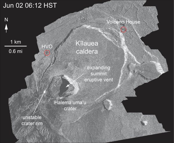
Kīlauea Volcano — Halema‘uma‘u Crater Slumping Animation
Kīlauea Volcano — Halema‘uma‘u Crater Slumping AnimationThis animated GIF shows a sequence of radar amplitude images that were acquired by the Italian Space Agency's Cosmo-SkyMed satellite system. The images illustrate changes to the caldera area of Kīlauea Volcano that occurred between May 5 and June 2 at 6:00 p.m. HST.

Kīlauea Volcano — Summit Plume

Kīlauea Volcano — Advancing Flow
Photo from 7AM helicopter overflight, hovering offshore and looking up the flowfront. Nearly all of the front was active and advancing; advance rates were estimated at an average of 250 feet/hour (76 m/hr), and as of 7AM the flow was 500 yards (457 m) from the ocean.
Photo from 7AM helicopter overflight, hovering offshore and looking up the flowfront. Nearly all of the front was active and advancing; advance rates were estimated at an average of 250 feet/hour (76 m/hr), and as of 7AM the flow was 500 yards (457 m) from the ocean.

Kīlauea LERZ lava flows and fissures, June 3, 11:00 a.m.
Kīlauea LERZ lava flows and fissures, June 3, 11:00 a.m.Map as of 11:00 a.m. HST, June 3, 2018. Given the dynamic nature of Kīlauea's lower East Rift Zone eruption, with changing vent locations, fissures starting and stopping, and varying rates of lava effusion, map details shown here are accurate as of the date/time noted. Shaded purple areas indicate lava flows erupted in 1840, 1955, 1960, and 2014-2015.

Kīlauea Volcano — Lava Near Four Corners
Northern edge of the fissure 8 flow front on the night of June 1, as it approached the intersection of Highways 132 and 137, known as "Four Corners."
Northern edge of the fissure 8 flow front on the night of June 1, as it approached the intersection of Highways 132 and 137, known as "Four Corners."