



Pahoehoe ropes form in the Wahaula Lava Flow across from Wahaula Visitor Center on Hawai'i Island during the Kilauea East Rift Zone (ERZ) eruption on 6/15/89.
Images
Hawaiian Volcano Observatory images of eruptive activity, field work, and more.
Filter Total Items: 4151

Pahoehoe from Kilauea eruption, 1989
Pahoehoe ropes form in the Wahaula Lava Flow across from Wahaula Visitor Center on Hawai'i Island during the Kilauea East Rift Zone (ERZ) eruption on 6/15/89.

Lava bubble burst explosion, Kīlauea, Hawai‘i
A thin-walled lava bubble expands and bursts. These "bubble bursts" occur when seawater infiltrates the lava tube system near the shore. Such bubble bursts produce translucent sheets of spatter, or limu o Pele.
A thin-walled lava bubble expands and bursts. These "bubble bursts" occur when seawater infiltrates the lava tube system near the shore. Such bubble bursts produce translucent sheets of spatter, or limu o Pele.
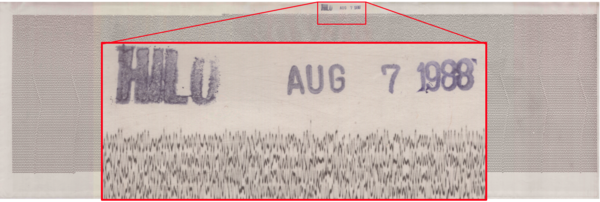
August 7, 1988 - Hilo Seismic Record
An example of a seismogram showing the vertical motion of the ground (recorded in Hilo on August 7, 1988). The lines on a seismogram are read left-to-right and top-to-bottom like the lines in a book. The red box shows a detail of the ground motion and the station and date stamp. USGS photo.
An example of a seismogram showing the vertical motion of the ground (recorded in Hilo on August 7, 1988). The lines on a seismogram are read left-to-right and top-to-bottom like the lines in a book. The red box shows a detail of the ground motion and the station and date stamp. USGS photo.
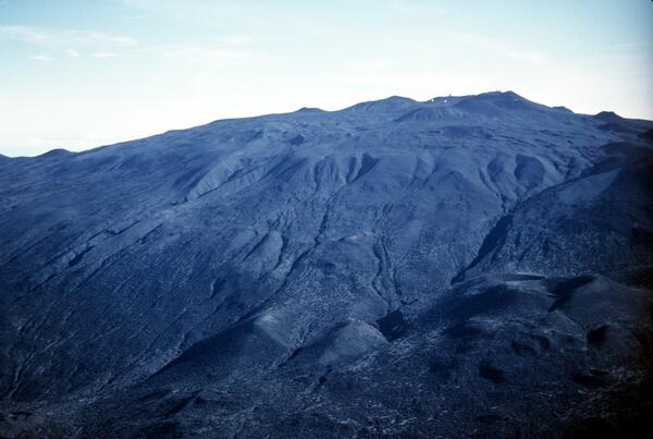
Glacial end moraine deposits on south flank of Mauna Kea, Hawai‘i
Glacial end moraine deposits on south flank of Mauna Kea, Hawai‘iGlacial end moraine deposits on south flank of Mauna Kea, Hawai‘i
Glacial end moraine deposits on south flank of Mauna Kea, Hawai‘i
Glacial end moraine deposits on south flank of Mauna Kea, Hawai‘iGlacial end moraine deposits on south flank of Mauna Kea, Hawai‘i

Northeast flank Mauna Kea, Hawai‘i from about 5,200 ft to summit. P...
Northeast flank Mauna Kea, Hawai‘i from about 5,200 ft to summit. P...The light colored lava flows in foreground are part of the older Laupahoehoe Volcanics, erupted between 70,000 to 13,000 years ago. one of the youngest cinder cones erupted by the volcano,
Northeast flank Mauna Kea, Hawai‘i from about 5,200 ft to summit. P...
Northeast flank Mauna Kea, Hawai‘i from about 5,200 ft to summit. P...The light colored lava flows in foreground are part of the older Laupahoehoe Volcanics, erupted between 70,000 to 13,000 years ago. one of the youngest cinder cones erupted by the volcano,

Pu‘umaKAHAKOkanaka, NE flank of Mauna Kea, Hawai‘i
Pu‘umaKAHAKOkanaka, NE flank of Mauna Kea, Hawai‘i12,398 ft elev according to USGS Geographic Names Information System
Pu‘umaKAHAKOkanaka, NE flank of Mauna Kea, Hawai‘i
Pu‘umaKAHAKOkanaka, NE flank of Mauna Kea, Hawai‘i12,398 ft elev according to USGS Geographic Names Information System

Upper south flank of Mauna Kea, Hawai‘i. Prominent cinder cone (low...
Upper south flank of Mauna Kea, Hawai‘i. Prominent cinder cone (low...Pu‘u Keonehehe‘e and the two small cones immediately to the northwest (left) are among the youngest cones erupted on the volcano, as recent as about 4,000 years ago. The other cones in this view are part of the Laupahoehoe Volcanics, but much older, dating to 70,000 years ago.
Upper south flank of Mauna Kea, Hawai‘i. Prominent cinder cone (low...
Upper south flank of Mauna Kea, Hawai‘i. Prominent cinder cone (low...Pu‘u Keonehehe‘e and the two small cones immediately to the northwest (left) are among the youngest cones erupted on the volcano, as recent as about 4,000 years ago. The other cones in this view are part of the Laupahoehoe Volcanics, but much older, dating to 70,000 years ago.

Tephra jet explosion, Kīlauea, Hawai‘i
Explosive interaction between lava and seawater blasts a tephra jet consisting of steam, hot water, black tephra, and molten fragments into the air. This explosion is directed primarily toward the sea, but many explosions also send a shower of lava more than 10 to 20 m inland.
Explosive interaction between lava and seawater blasts a tephra jet consisting of steam, hot water, black tephra, and molten fragments into the air. This explosion is directed primarily toward the sea, but many explosions also send a shower of lava more than 10 to 20 m inland.

Lava flow enters Queens Bath, Kilauea Volcano, 1987
Lava flow enters Queens Bath, Kilauea Volcano, 1987Bystanders watch steam rising from Queens Bath as lava flow enters the water. Lava overran Highway 130 at 0748 Hawaii Standard Time on the same morning at the western margin of the Kapa'ahu flow. By the end of the day, Punalu'u heiau was overrun, and Queens Bath was filled with lava.
Lava flow enters Queens Bath, Kilauea Volcano, 1987
Lava flow enters Queens Bath, Kilauea Volcano, 1987Bystanders watch steam rising from Queens Bath as lava flow enters the water. Lava overran Highway 130 at 0748 Hawaii Standard Time on the same morning at the western margin of the Kapa'ahu flow. By the end of the day, Punalu'u heiau was overrun, and Queens Bath was filled with lava.

Aerial view of waning lava fountain, Kilauea Volcano, 1985
Aerial view of waning lava fountain, Kilauea Volcano, 1985Aerial view, from the east, of waning lava fountain from Pu'u 'O'o on Hawai'i Island's Kilauea Volcano. Taken at the end of eruption episode 32. Pu'u 'O'o rose 209 meters above the pre-1983 surface (928 meters above sea level).
Aerial view of waning lava fountain, Kilauea Volcano, 1985
Aerial view of waning lava fountain, Kilauea Volcano, 1985Aerial view, from the east, of waning lava fountain from Pu'u 'O'o on Hawai'i Island's Kilauea Volcano. Taken at the end of eruption episode 32. Pu'u 'O'o rose 209 meters above the pre-1983 surface (928 meters above sea level).

Gas Plume during the 1985 eruption of Kīlauea, Hawaii
Gas Plume during the 1985 eruption of Kīlauea, HawaiiGas Plume during the 1985 eruption of Kīlauea, Hawaii blocks out the sun. This image was taken from Kīlauea summit during episode 32 of the Pu‘u ‘Ō‘ō eruption on the middle East Rift Zone of Kīlauea. USGS image by J.D. Griggs on April 22, 1985.
Gas Plume during the 1985 eruption of Kīlauea, Hawaii
Gas Plume during the 1985 eruption of Kīlauea, HawaiiGas Plume during the 1985 eruption of Kīlauea, Hawaii blocks out the sun. This image was taken from Kīlauea summit during episode 32 of the Pu‘u ‘Ō‘ō eruption on the middle East Rift Zone of Kīlauea. USGS image by J.D. Griggs on April 22, 1985.

Maps of Mauna Loa 1984 lava flows
Maps showing lava flow progression during the 1984 eruption of Mauna Loa. These maps were featured in the Hawai‘i Tribune-Herald newspaper on March 27, 1984 (top) and March 30, 1984 (bottom).
Maps showing lava flow progression during the 1984 eruption of Mauna Loa. These maps were featured in the Hawai‘i Tribune-Herald newspaper on March 27, 1984 (top) and March 30, 1984 (bottom).

Lava fountain 450 m (1,475 ft) high from Kīlauea Pu‘u ‘Ō‘ō eruption...
Lava fountain 450 m (1,475 ft) high from Kīlauea Pu‘u ‘Ō‘ō eruption...Lava fragments ejected by lava fountains are called tephra, a general term for all fragments, regardless of size, that are blasted into the air by explosive activity. A variety of terms are also used to describe specific types of fragments, including Pele's hair, Pele's tears, scoria, spatter, bombs, and reticulite.
Lava fountain 450 m (1,475 ft) high from Kīlauea Pu‘u ‘Ō‘ō eruption...
Lava fountain 450 m (1,475 ft) high from Kīlauea Pu‘u ‘Ō‘ō eruption...Lava fragments ejected by lava fountains are called tephra, a general term for all fragments, regardless of size, that are blasted into the air by explosive activity. A variety of terms are also used to describe specific types of fragments, including Pele's hair, Pele's tears, scoria, spatter, bombs, and reticulite.

Low lava fountains from 1984 Mauna Loa "2,900-m vents" signaled dec...
Low lava fountains from 1984 Mauna Loa "2,900-m vents" signaled dec...Lava production from these "2,900-m vents" began to decrease in late March but declined most rapidly between April 7 and 9 from about 300,000 m3 per hour to less than 100,000 m3 per hour. Photo taken at 9:09 a.m.
Low lava fountains from 1984 Mauna Loa "2,900-m vents" signaled dec...
Low lava fountains from 1984 Mauna Loa "2,900-m vents" signaled dec...Lava production from these "2,900-m vents" began to decrease in late March but declined most rapidly between April 7 and 9 from about 300,000 m3 per hour to less than 100,000 m3 per hour. Photo taken at 9:09 a.m.

Lava flows from the 1984 eruption of Mauna Loa loom above the town ...
Lava flows from the 1984 eruption of Mauna Loa loom above the town ...Lava flows from the 1984 eruption of Mauna Loa loom above the town of Hilo. Photograph taken near the Hilo airport on April 4.
Lava flows from the 1984 eruption of Mauna Loa loom above the town ...
Lava flows from the 1984 eruption of Mauna Loa loom above the town ...Lava flows from the 1984 eruption of Mauna Loa loom above the town of Hilo. Photograph taken near the Hilo airport on April 4.

Lava fountains erupting from fissure on upper northERZ of Mauna Loa...
Lava fountains erupting from fissure on upper northERZ of Mauna Loa...Pohaku Hanalei cinder-spatter cone (upper left) is located about 3.2 km (2 mi) NE from the north edge of the caldera rim. Eruption rates were as high as 2.9 million m3 per hour during the first 6 hours of the eruption, then diminished to about 0.5 million m3 per hour for the next 12 days.
Lava fountains erupting from fissure on upper northERZ of Mauna Loa...
Lava fountains erupting from fissure on upper northERZ of Mauna Loa...Pohaku Hanalei cinder-spatter cone (upper left) is located about 3.2 km (2 mi) NE from the north edge of the caldera rim. Eruption rates were as high as 2.9 million m3 per hour during the first 6 hours of the eruption, then diminished to about 0.5 million m3 per hour for the next 12 days.

Aa lava flows erupting from Mauna Loa.
Aa lava flows erupting from Mauna Loa.

Low fountain of lava from Pu'u 'O'o, Kilauea Volcano, 1983
Low fountain of lava from Pu'u 'O'o, Kilauea Volcano, 1983Low fountain, approximately 50 meters high, from Pu'u 'O'o on Hawai'i Island's Kilauea Volcano (viewed from the north). Lava issuing from the breach in the northeast rim of the crater produced an 'a'a flow that extended more than 4 kilometers. Eruption episode 8.
Low fountain of lava from Pu'u 'O'o, Kilauea Volcano, 1983
Low fountain of lava from Pu'u 'O'o, Kilauea Volcano, 1983Low fountain, approximately 50 meters high, from Pu'u 'O'o on Hawai'i Island's Kilauea Volcano (viewed from the north). Lava issuing from the breach in the northeast rim of the crater produced an 'a'a flow that extended more than 4 kilometers. Eruption episode 8.

100-meter lava fountain, Kilauea Volcano, 1983
Pu'u 'O'o fountain approximately 100 meters high during eruption episode 8 on Hawai'i Island's Kilauea Volcano. Dark clots of spatter land near the base of the fountain, contributing to the growth of the cone. Less dense cinder, visible in the upper right, is carried downwind of the cone.
Pu'u 'O'o fountain approximately 100 meters high during eruption episode 8 on Hawai'i Island's Kilauea Volcano. Dark clots of spatter land near the base of the fountain, contributing to the growth of the cone. Less dense cinder, visible in the upper right, is carried downwind of the cone.

Lava ball, Kilauea Volcano, 1983
Accretionary lava ball comes to rest on the grass after rolling off the top of an 'a'a flow in Royal Gardens subdivision on Hawai'i Island's Kilauea Volcano. Accretionary lava balls form as viscous lava is molded around a core of already-soldified lava.
Accretionary lava ball comes to rest on the grass after rolling off the top of an 'a'a flow in Royal Gardens subdivision on Hawai'i Island's Kilauea Volcano. Accretionary lava balls form as viscous lava is molded around a core of already-soldified lava.

Pu'u 'O'o cinder-and-spatter cone, Kilauea Volcano, 1983
Pu'u 'O'o cinder-and-spatter cone, Kilauea Volcano, 1983View at dusk of the young Pu'u 'O'o cinder-and-spatter cone, with fountain 40 meters high, on Hawai'i Island's Kilauea Volcano (episode 5).
Pu'u 'O'o cinder-and-spatter cone, Kilauea Volcano, 1983
Pu'u 'O'o cinder-and-spatter cone, Kilauea Volcano, 1983View at dusk of the young Pu'u 'O'o cinder-and-spatter cone, with fountain 40 meters high, on Hawai'i Island's Kilauea Volcano (episode 5).