



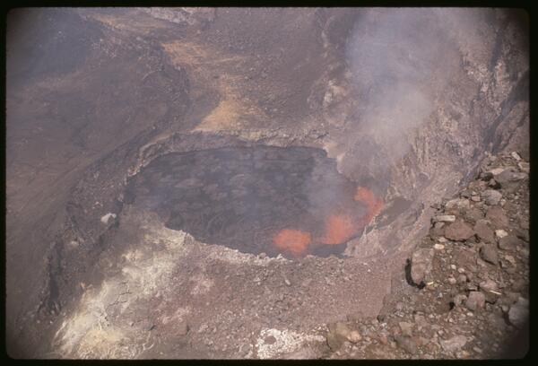
A telephoto image of vents erupting on the floor of Halema‘uma‘u crater, at the summit of Kīlauea, in 1967. NPS photo by C. Stoughton.
Images
Hawaiian Volcano Observatory images of eruptive activity, field work, and more.
Filter Total Items: 4146

Halema‘uma‘u crater erupting in 1967
A telephoto image of vents erupting on the floor of Halema‘uma‘u crater, at the summit of Kīlauea, in 1967. NPS photo by C. Stoughton.

Halema‘uma‘u crater erupting in 1967
An aerial overview of Halema‘uma‘u crater erupting in early December 1967. USGS image.
An aerial overview of Halema‘uma‘u crater erupting in early December 1967. USGS image.

1967 felt earthquake report for M3.9 earthquake at Kīlauea
1967 felt earthquake report for M3.9 earthquake at KīlaueaEarthquake report card from 1967 containing detailed information of personally observed effects from a M3.9 earthquake at the summit of Kīlauea. HVO staff distributed the report cards to local citizens between 1930 and 1989.
1967 felt earthquake report for M3.9 earthquake at Kīlauea
1967 felt earthquake report for M3.9 earthquake at KīlaueaEarthquake report card from 1967 containing detailed information of personally observed effects from a M3.9 earthquake at the summit of Kīlauea. HVO staff distributed the report cards to local citizens between 1930 and 1989.
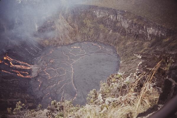
March 1965 Kīlauea eruption near Makaopuhi Crater
A fissure on the northwestern crater wall of Makaopuhi Crater on the East Rift Zone of Kīlauea sent lava cascading into the deepest portion of the crater, forming a lava lake. USGS photo taken by E. Endo on March 6, 1965, from a viewing area along the old Chain of Craters Road.
A fissure on the northwestern crater wall of Makaopuhi Crater on the East Rift Zone of Kīlauea sent lava cascading into the deepest portion of the crater, forming a lava lake. USGS photo taken by E. Endo on March 6, 1965, from a viewing area along the old Chain of Craters Road.
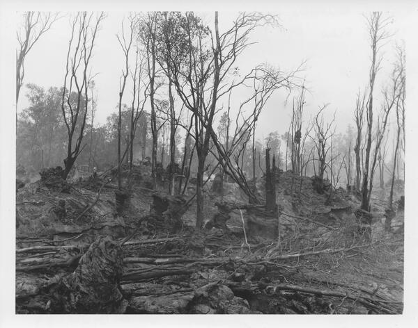
1961 Fissure Eruption near Nāpau Crater
The 1961 fissure eruption near Nāpau Crater was a short-lived but notable event on Kīlauea’s East Rift Zone, occurring in late September. Over two days, lava erupted from vents along a 13-mile stretch, producing 13 small flows and lava fountains that reached heights of up to 400 feet, with the largest flows occurring near Pāhoa.
The 1961 fissure eruption near Nāpau Crater was a short-lived but notable event on Kīlauea’s East Rift Zone, occurring in late September. Over two days, lava erupted from vents along a 13-mile stretch, producing 13 small flows and lava fountains that reached heights of up to 400 feet, with the largest flows occurring near Pāhoa.
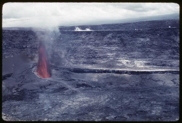
July 1961 Summit Eruption
The July 1961 eruption at Halemaʻumaʻu was the third summit eruption of that year, continuing the pattern of vigorous volcanic activity at Kīlauea. This event featured sustained lava fountaining and further infilling of the crater, building upon the changes initiated by the February and March eruptions.
The July 1961 eruption at Halemaʻumaʻu was the third summit eruption of that year, continuing the pattern of vigorous volcanic activity at Kīlauea. This event featured sustained lava fountaining and further infilling of the crater, building upon the changes initiated by the February and March eruptions.
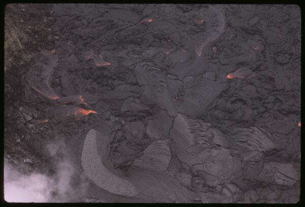
March 1961 Halemaʻumaʻu Eruption
The March 1961 eruption at Halemaʻumaʻu was the second of three summit eruptions at Kīlauea that year, marked by renewed lava activity within the northeast collapse pit formed in February. This phase featured vigorous lava fountaining, crater floor uplift, and the gradual infilling of the pit, reflecting continued magma supply and dynamic summit processes.
The March 1961 eruption at Halemaʻumaʻu was the second of three summit eruptions at Kīlauea that year, marked by renewed lava activity within the northeast collapse pit formed in February. This phase featured vigorous lava fountaining, crater floor uplift, and the gradual infilling of the pit, reflecting continued magma supply and dynamic summit processes.
February 1961 Halemaʻumaʻu Summit Eruption
The February 1961 summit eruption of Kīlauea marked the beginning of a year of intense volcanic activity, characterized by three distinct summit eruptive phases.
The February 1961 summit eruption of Kīlauea marked the beginning of a year of intense volcanic activity, characterized by three distinct summit eruptive phases.

Displacement of Kapoho fault scarp, Kīlauea, Hawai‘i, caused by mag...
Displacement of Kapoho fault scarp, Kīlauea, Hawai‘i, caused by mag...View westward along the Kapoho fault scarp in the village of Kapoho following a swarm of earthquakes in the area. The ground cracking was caused by subsidence of a graben (down-dropped block) that spanned the community.
Displacement of Kapoho fault scarp, Kīlauea, Hawai‘i, caused by mag...
Displacement of Kapoho fault scarp, Kīlauea, Hawai‘i, caused by mag...View westward along the Kapoho fault scarp in the village of Kapoho following a swarm of earthquakes in the area. The ground cracking was caused by subsidence of a graben (down-dropped block) that spanned the community.

Lava fountain in early morning, Kīlauea Iki, Kīlauea, Hawai‘i
Lava fountain in early morning, Kīlauea Iki, Kīlauea, Hawai‘iGreat quantities of lava pour from the base of a 480-m-tall (1,575 ft) fountain about 65 minutes after the start of episode 16. Lava discharge at this time was about 1.3 million cubic meters per hour (1.7 million cubic yards), which sent lava over the entire lake by 4:05 a.m.
Lava fountain in early morning, Kīlauea Iki, Kīlauea, Hawai‘i
Lava fountain in early morning, Kīlauea Iki, Kīlauea, Hawai‘iGreat quantities of lava pour from the base of a 480-m-tall (1,575 ft) fountain about 65 minutes after the start of episode 16. Lava discharge at this time was about 1.3 million cubic meters per hour (1.7 million cubic yards), which sent lava over the entire lake by 4:05 a.m.

Measuring Kīlauea magnetic field strength
Hawaiian Volcano Observatory Scientists at the rim of Kīlauea volcano measuring variations in magnetic field strength in 1950. Photo by Ray E. Wilcox.
Hawaiian Volcano Observatory Scientists at the rim of Kīlauea volcano measuring variations in magnetic field strength in 1950. Photo by Ray E. Wilcox.

Fissure of lava fountains erupting from Mauna Loa's upper SW rift z...
Fissure of lava fountains erupting from Mauna Loa's upper SW rift z...Fissure of lava fountains erupting from Mauna Loa's upper southwest rift zone, June 2, 1950. Plumes of volcanic gas rise high into the air. Aerial photograph taken by the Air National Guard.
Fissure of lava fountains erupting from Mauna Loa's upper SW rift z...
Fissure of lava fountains erupting from Mauna Loa's upper SW rift z...Fissure of lava fountains erupting from Mauna Loa's upper southwest rift zone, June 2, 1950. Plumes of volcanic gas rise high into the air. Aerial photograph taken by the Air National Guard.

Ka‘apuna lava flow, Mauna Loa 1950, creates steam plume as it enter...
Ka‘apuna lava flow, Mauna Loa 1950, creates steam plume as it enter...The Ka‘apuna flow traveled from the Southwest Rift Zone vent (7,800 ft elevation) to the coast in just 17 hours.
Ka‘apuna lava flow, Mauna Loa 1950, creates steam plume as it enter...
Ka‘apuna lava flow, Mauna Loa 1950, creates steam plume as it enter...The Ka‘apuna flow traveled from the Southwest Rift Zone vent (7,800 ft elevation) to the coast in just 17 hours.

Ka‘apuna lava flow enters the ocean during Mauna Loa 1950 eruption....
Ka‘apuna lava flow enters the ocean during Mauna Loa 1950 eruption....Photograph taken from sea aboard a ship.

A fast-moving ‘A‘ā flow erupted from Mauna Loa in 1950 as it advanc...
A fast-moving ‘A‘ā flow erupted from Mauna Loa in 1950 as it advanc...Aerial photograph shows the Ka‘apuna lava flow erupted from Mauna Loa in 1950 as it advanced through the forest at about 3,000 feet elevation on the morning of June 2. This rapidly moving ‘a‘ā lava flow traveled from the Southwest Rift Zone vent to the ocean in about 17 hours. Earlier flows from this same eruption reached the ocean in as little as three hours.
A fast-moving ‘A‘ā flow erupted from Mauna Loa in 1950 as it advanc...
A fast-moving ‘A‘ā flow erupted from Mauna Loa in 1950 as it advanc...Aerial photograph shows the Ka‘apuna lava flow erupted from Mauna Loa in 1950 as it advanced through the forest at about 3,000 feet elevation on the morning of June 2. This rapidly moving ‘a‘ā lava flow traveled from the Southwest Rift Zone vent to the ocean in about 17 hours. Earlier flows from this same eruption reached the ocean in as little as three hours.

Damage to Hilo from the Tsunami that struck on April Foolʻs Day in 1946
Damage to Hilo from the Tsunami that struck on April Foolʻs Day in 1946Damage to Hilo as a result of the tsunami caused by the Aleutian Islands earthquake on April 1, 1946. The tsunami arrived in Hilo nearly five hours after the earthquake occurred. In this photo, debris nearly covers a vehicle in the lower left part of the image (Source unknown).
Damage to Hilo from the Tsunami that struck on April Foolʻs Day in 1946
Damage to Hilo from the Tsunami that struck on April Foolʻs Day in 1946Damage to Hilo as a result of the tsunami caused by the Aleutian Islands earthquake on April 1, 1946. The tsunami arrived in Hilo nearly five hours after the earthquake occurred. In this photo, debris nearly covers a vehicle in the lower left part of the image (Source unknown).

Aerial photograph of the 1942 Mauna Loa lava flow spreading downslo...
Aerial photograph of the 1942 Mauna Loa lava flow spreading downslo...Aerial photograph of the 1942 Mauna Loa lava flow spreading downslope toward Hilo; smoke from burning trees in center of flow. Scattered cinder cones at the summit of Mauna Kea, top of photograph.
Aerial photograph of the 1942 Mauna Loa lava flow spreading downslo...
Aerial photograph of the 1942 Mauna Loa lava flow spreading downslo...Aerial photograph of the 1942 Mauna Loa lava flow spreading downslope toward Hilo; smoke from burning trees in center of flow. Scattered cinder cones at the summit of Mauna Kea, top of photograph.

Aerial view by the Naval Air Service of the 1933 Mauna Loa eruption...
Aerial view by the Naval Air Service of the 1933 Mauna Loa eruption...Aerial view by the Naval Air Service of the 1933 Mauna Loa eruption from a fissure across the rim and floor of Moku‘āweoweo Crater.
Aerial view by the Naval Air Service of the 1933 Mauna Loa eruption...
Aerial view by the Naval Air Service of the 1933 Mauna Loa eruption...Aerial view by the Naval Air Service of the 1933 Mauna Loa eruption from a fissure across the rim and floor of Moku‘āweoweo Crater.

1924 explosive eruptions from Halemaʻumaʻu
Photographs of the 1924 explosive eruptions from Halemaʻumaʻu. The photograph on the left is from the Uēkahuna bluff on May 18, 1924, by Kenichi Maehara. The photograph on the right is from near the present-day site of Volcano House on May 22, 1924, by Tai Sing Loo.
Photographs of the 1924 explosive eruptions from Halemaʻumaʻu. The photograph on the left is from the Uēkahuna bluff on May 18, 1924, by Kenichi Maehara. The photograph on the right is from near the present-day site of Volcano House on May 22, 1924, by Tai Sing Loo.

Ruy H. Finch (1890-1957)
The founder of the Lassen Volcano Observatory (1926-1935) and second Director of the Hawaiian Volcano Observatory (1940-1951), Ruy Herbert Finch conducted research in both Hawaii and throughout the Western United States.
The founder of the Lassen Volcano Observatory (1926-1935) and second Director of the Hawaiian Volcano Observatory (1940-1951), Ruy Herbert Finch conducted research in both Hawaii and throughout the Western United States.

100 years ago at Kīlauea: The 1924 explosive eruption described by Thomas Jaggar
100 years ago at Kīlauea: The 1924 explosive eruption described by Thomas JaggarThis is the thumbnail image for a two-minute video summarizing the 1924 explosive eruption at the summit of Kīlauea, which occurred 100 years ago. The video is narrated by Thomas Jaggar, who founded the Hawaiian Volcano Observatory in 1912. His description of the 1924 eruption was recorded in 1951 by Hawaiʻi Volcanoes National Park.
100 years ago at Kīlauea: The 1924 explosive eruption described by Thomas Jaggar
100 years ago at Kīlauea: The 1924 explosive eruption described by Thomas JaggarThis is the thumbnail image for a two-minute video summarizing the 1924 explosive eruption at the summit of Kīlauea, which occurred 100 years ago. The video is narrated by Thomas Jaggar, who founded the Hawaiian Volcano Observatory in 1912. His description of the 1924 eruption was recorded in 1951 by Hawaiʻi Volcanoes National Park.