Kalapana Gardens subdivision inundated by pāhoehoe, Kīlauea
Kalapana Gardens subdivision inundated by pāhoehoe, KīlaueaKalapana Gardens subdivision inundated by pāhoehoe flows, Kīlauea Volcano, Hawai‘i


Official websites use .gov
A .gov website belongs to an official government organization in the United States.

Secure .gov websites use HTTPS
A lock () or https:// means you’ve safely connected to the .gov website. Share sensitive information only on official, secure websites.

Hawaiian Volcano Observatory images of eruptive activity, field work, and more.

Kalapana Gardens subdivision inundated by pāhoehoe flows, Kīlauea Volcano, Hawai‘i
Kalapana Gardens subdivision inundated by pāhoehoe flows, Kīlauea Volcano, Hawai‘i

Harry K. Brown Park was originally called "Wai'akolea Park." It was renamed "Harry Ka'ina Brown Memorial Park" in 1953 after Brown, a county auditor, whose ancestral home was in Kalapana. Thick smoke is from burning asphalt.
Harry K. Brown Park was originally called "Wai'akolea Park." It was renamed "Harry Ka'ina Brown Memorial Park" in 1953 after Brown, a county auditor, whose ancestral home was in Kalapana. Thick smoke is from burning asphalt.

The left edge of the lava flow is following the inland contours of Hakuma horst, the fault block to the left, which is directing the flow into the heart of Kalapana.
The left edge of the lava flow is following the inland contours of Hakuma horst, the fault block to the left, which is directing the flow into the heart of Kalapana.

Aerial view of pāhoehoe flow encroaching on the Kalapana community. Hakuma horst, a raised fault block, is on the left. To the right of the point are fishponds, and to their right, Walter's Kalapana Store and Drive Inn. In the large trapezoidal plot are Mauna Kea Congregational Church and hall.
Aerial view of pāhoehoe flow encroaching on the Kalapana community. Hakuma horst, a raised fault block, is on the left. To the right of the point are fishponds, and to their right, Walter's Kalapana Store and Drive Inn. In the large trapezoidal plot are Mauna Kea Congregational Church and hall.

View looking uphill at surface flows advancing down a steep slope (Pulama pali) between the east rift zone and the coastal plain of Kīlauea Volcano. Overflows from the channel on the right are building levees of pāhoehoe. Within a few days, crust accreting inward from the levees built a roof over the channel, forming a new lava tube.
View looking uphill at surface flows advancing down a steep slope (Pulama pali) between the east rift zone and the coastal plain of Kīlauea Volcano. Overflows from the channel on the right are building levees of pāhoehoe. Within a few days, crust accreting inward from the levees built a roof over the channel, forming a new lava tube.

Lava flows from a lava tube into the sea near Kupapau Point on 11/27/1989. From the Kilauea East Rift Zone (ERZ) eruption, eruption pisode 48, Kupapau lava flow. Hawai'i Island.
Lava flows from a lava tube into the sea near Kupapau Point on 11/27/1989. From the Kilauea East Rift Zone (ERZ) eruption, eruption pisode 48, Kupapau lava flow. Hawai'i Island.

Pahoehoe ropes form in the Wahaula Lava Flow across from Wahaula Visitor Center on Hawai'i Island during the Kilauea East Rift Zone (ERZ) eruption on 6/15/89.
Pahoehoe ropes form in the Wahaula Lava Flow across from Wahaula Visitor Center on Hawai'i Island during the Kilauea East Rift Zone (ERZ) eruption on 6/15/89.

A thin-walled lava bubble expands and bursts. These "bubble bursts" occur when seawater infiltrates the lava tube system near the shore. Such bubble bursts produce translucent sheets of spatter, or limu o Pele.
A thin-walled lava bubble expands and bursts. These "bubble bursts" occur when seawater infiltrates the lava tube system near the shore. Such bubble bursts produce translucent sheets of spatter, or limu o Pele.
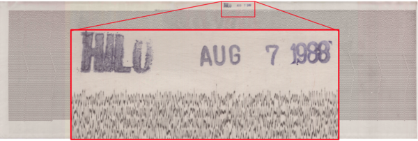
An example of a seismogram showing the vertical motion of the ground (recorded in Hilo on August 7, 1988). The lines on a seismogram are read left-to-right and top-to-bottom like the lines in a book. The red box shows a detail of the ground motion and the station and date stamp. USGS photo.
An example of a seismogram showing the vertical motion of the ground (recorded in Hilo on August 7, 1988). The lines on a seismogram are read left-to-right and top-to-bottom like the lines in a book. The red box shows a detail of the ground motion and the station and date stamp. USGS photo.
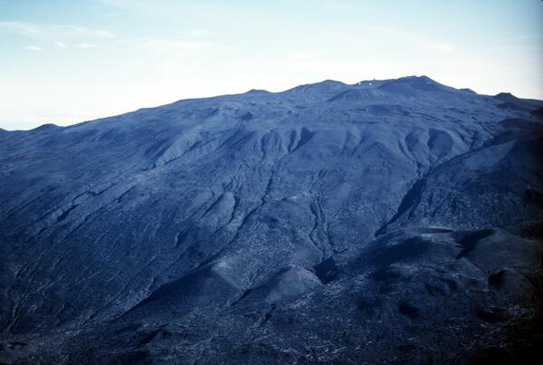
Glacial end moraine deposits on south flank of Mauna Kea, Hawai‘i
Glacial end moraine deposits on south flank of Mauna Kea, Hawai‘i

The light colored lava flows in foreground are part of the older Laupahoehoe Volcanics, erupted between 70,000 to 13,000 years ago. one of the youngest cinder cones erupted by the volcano,
The light colored lava flows in foreground are part of the older Laupahoehoe Volcanics, erupted between 70,000 to 13,000 years ago. one of the youngest cinder cones erupted by the volcano,

12,398 ft elev according to USGS Geographic Names Information System
12,398 ft elev according to USGS Geographic Names Information System

Pu‘u Keonehehe‘e and the two small cones immediately to the northwest (left) are among the youngest cones erupted on the volcano, as recent as about 4,000 years ago. The other cones in this view are part of the Laupahoehoe Volcanics, but much older, dating to 70,000 years ago.
Pu‘u Keonehehe‘e and the two small cones immediately to the northwest (left) are among the youngest cones erupted on the volcano, as recent as about 4,000 years ago. The other cones in this view are part of the Laupahoehoe Volcanics, but much older, dating to 70,000 years ago.

Explosive interaction between lava and seawater blasts a tephra jet consisting of steam, hot water, black tephra, and molten fragments into the air. This explosion is directed primarily toward the sea, but many explosions also send a shower of lava more than 10 to 20 m inland.
Explosive interaction between lava and seawater blasts a tephra jet consisting of steam, hot water, black tephra, and molten fragments into the air. This explosion is directed primarily toward the sea, but many explosions also send a shower of lava more than 10 to 20 m inland.

Bystanders watch steam rising from Queens Bath as lava flow enters the water. Lava overran Highway 130 at 0748 Hawaii Standard Time on the same morning at the western margin of the Kapa'ahu flow. By the end of the day, Punalu'u heiau was overrun, and Queens Bath was filled with lava.
Bystanders watch steam rising from Queens Bath as lava flow enters the water. Lava overran Highway 130 at 0748 Hawaii Standard Time on the same morning at the western margin of the Kapa'ahu flow. By the end of the day, Punalu'u heiau was overrun, and Queens Bath was filled with lava.

Aerial view, from the east, of waning lava fountain from Pu'u 'O'o on Hawai'i Island's Kilauea Volcano. Taken at the end of eruption episode 32. Pu'u 'O'o rose 209 meters above the pre-1983 surface (928 meters above sea level).
Aerial view, from the east, of waning lava fountain from Pu'u 'O'o on Hawai'i Island's Kilauea Volcano. Taken at the end of eruption episode 32. Pu'u 'O'o rose 209 meters above the pre-1983 surface (928 meters above sea level).

Gas Plume during the 1985 eruption of Kīlauea, Hawaii blocks out the sun. This image was taken from Kīlauea summit during episode 32 of the Pu‘u ‘Ō‘ō eruption on the middle East Rift Zone of Kīlauea. USGS image by J.D. Griggs on April 22, 1985.
Gas Plume during the 1985 eruption of Kīlauea, Hawaii blocks out the sun. This image was taken from Kīlauea summit during episode 32 of the Pu‘u ‘Ō‘ō eruption on the middle East Rift Zone of Kīlauea. USGS image by J.D. Griggs on April 22, 1985.

Maps showing lava flow progression during the 1984 eruption of Mauna Loa. These maps were featured in the Hawai‘i Tribune-Herald newspaper on March 27, 1984 (top) and March 30, 1984 (bottom).
Maps showing lava flow progression during the 1984 eruption of Mauna Loa. These maps were featured in the Hawai‘i Tribune-Herald newspaper on March 27, 1984 (top) and March 30, 1984 (bottom).

Lava fragments ejected by lava fountains are called tephra, a general term for all fragments, regardless of size, that are blasted into the air by explosive activity. A variety of terms are also used to describe specific types of fragments, including Pele's hair, Pele's tears, scoria, spatter, bombs, and reticulite.
Lava fragments ejected by lava fountains are called tephra, a general term for all fragments, regardless of size, that are blasted into the air by explosive activity. A variety of terms are also used to describe specific types of fragments, including Pele's hair, Pele's tears, scoria, spatter, bombs, and reticulite.

Lava production from these "2,900-m vents" began to decrease in late March but declined most rapidly between April 7 and 9 from about 300,000 m3 per hour to less than 100,000 m3 per hour. Photo taken at 9:09 a.m.
Lava production from these "2,900-m vents" began to decrease in late March but declined most rapidly between April 7 and 9 from about 300,000 m3 per hour to less than 100,000 m3 per hour. Photo taken at 9:09 a.m.

Lava flows from the 1984 eruption of Mauna Loa loom above the town of Hilo. Photograph taken near the Hilo airport on April 4.
Lava flows from the 1984 eruption of Mauna Loa loom above the town of Hilo. Photograph taken near the Hilo airport on April 4.