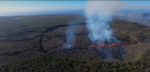
U.S. flag

An official website of the United States government

Images

Hawaiian Volcano Observatory images of eruptive activity, field work, and more.

Filter Total Items: 3867
Color photograph of scientist removing camera from building
Removal of webcams from Okamura Building tower

Hawaiian Volcano Observatory geologists visited HVO's former office at Uēkahuna bluff, on Kīlauea's caldera rim, for likely the last time. Their job was to remove the remaining webcams in the observation tower of the Okamura Building, above the former Jaggar Museum.

Hawaiian Volcano Observatory geologists visited HVO's former office at Uēkahuna bluff, on Kīlauea's caldera rim, for likely the last time. Their job was to remove the remaining webcams in the observation tower of the Okamura Building, above the former Jaggar Museum.

Color photograph of volcano observatory staff
USGS Hawaiian Volcano Observatory staff in 2024.

USGS Hawaiian Volcano Observatory staff in January 2024. Photograph taken near the coast of Hilo on the Island of Hawai‘i.  

Color cross-section illustration of a volcano's magma plumbing system
Cross section of proposed magma plumbing system beneath the surface of Kīlauea

A cross section of proposed magma plumbing system beneath the surface of Kīlauea. “H” marks the Halema‘uma‘u reservoir; “SC” marks the south caldera reservoir; “K” marks the Keanakāko‘i reservoir; “HKIT” notes a connection between the Halema‘uma‘u reservoir and Kīlauea Iki; SWRZ denotes Southwest Rift Zone.

A cross section of proposed magma plumbing system beneath the surface of Kīlauea. “H” marks the Halema‘uma‘u reservoir; “SC” marks the south caldera reservoir; “K” marks the Keanakāko‘i reservoir; “HKIT” notes a connection between the Halema‘uma‘u reservoir and Kīlauea Iki; SWRZ denotes Southwest Rift Zone.

Color map showing earthquake locations and ground deformation
January 8, 2024—Summary map of recent unrest at Kīlauea Volcano

This map shows recent unrest at Kīlauea volcano. Yellow circles mark earthquake locations from November 30, 2023 through January 8, 2024, as recorded by HVO seismometers.

Color map showing the distribution of lava flows from Mauna Loa since 1843
Maps showing the extents of Mauna Loa lava flows erupted from 1843–2022

Map showing the subaerial extents of Mauna Loa lava flows erupted during 1843–2022 CE. Lava flow hazard zones and districts of the County of Hawai‘i are also depicted.

Color map of earthquakes and ground deformation
December 12, 2023—Summary map of unrest at Kīlauea Volcano

This map shows recent unrest at Kīlauea volcano. Yellow circles denote earthquake locations from November 11–December 12, 2023, as recorded by HVO seismometers. Unlike previous maps of unrest in October and November, this one shows a new locus of seismicity in an area known as the East Rift connector.

This map shows recent unrest at Kīlauea volcano. Yellow circles denote earthquake locations from November 11–December 12, 2023, as recorded by HVO seismometers. Unlike previous maps of unrest in October and November, this one shows a new locus of seismicity in an area known as the East Rift connector.

Color image of a calendar of events
HVO Volcano Awareness Month 2024 Calendar of Events

Island of Hawaiʻi Volcano Awareness Month programs scheduled throughout the month of January 2024.

Map showing location someone walked
Kīlauea to Kealakomo

Map showing the path that Rev. William Ellis took walking from the summit of Kīlauea to Kealakomo on August 2, 1823.

Map showing the path that Rev. William Ellis took walking from the summit of Kīlauea to Kealakomo on August 2, 1823.

Color plots of seismic data
24 hours of seismic signals at station WRM

The seismogram tracks 24 hours of signals at station WRM, just west of Halemaʻumaʻu crater at the summit of Kīlauea. Examples of spectrographic helicopter noise, a small VT event, and a larger VT event are given below the seismogram.

The seismogram tracks 24 hours of signals at station WRM, just west of Halemaʻumaʻu crater at the summit of Kīlauea. Examples of spectrographic helicopter noise, a small VT event, and a larger VT event are given below the seismogram.

Color plot of volcano deformation data
Graph of GPS line-length across the Mauna Loa summit, 2022–2023

Plot showing the distance between two GPS stations on Mauna Loa from February 2022 to November 2023. Station MOKP is on the north side of Mokuʻāweoweo and station MLES is east of Mokuʻāweoweo. This plot shows how the distance between these two stations increased before the 2022 Mauna Loa eruption, indicating that the volcano was inflating.

Plot showing the distance between two GPS stations on Mauna Loa from February 2022 to November 2023. Station MOKP is on the north side of Mokuʻāweoweo and station MLES is east of Mokuʻāweoweo. This plot shows how the distance between these two stations increased before the 2022 Mauna Loa eruption, indicating that the volcano was inflating.

Color map of volcano earthquakes
Map of earthquakes at the Mauna Loa summit, October–November 2023

Map showing the locations of earthquakes beneath Mauna Loa between October 31, 2023, and November 9, 2023. The earthquake colors indicate their depth. Most earthquakes have occurred at depths of 40–60 km (25–37 mi) beneath Mokuʻāweoweo, though some have occurred at shallower depths within 16 km (10 mi) of the ground surface. USGS map.

Map showing the locations of earthquakes beneath Mauna Loa between October 31, 2023, and November 9, 2023. The earthquake colors indicate their depth. Most earthquakes have occurred at depths of 40–60 km (25–37 mi) beneath Mokuʻāweoweo, though some have occurred at shallower depths within 16 km (10 mi) of the ground surface. USGS map.

Color photograph of caldera floor
November 8, 2023 — Mauna Loa summit webcam repairs

A view of Moku‘āweoweo (Mauna Loa's summit caldera) from the rim on the northwest side. The lava flows that flooded much of the caldera floor during the brief summit phase of the 2022 eruption are nearly indistinguishable from previous lava flows.

A view of Moku‘āweoweo (Mauna Loa's summit caldera) from the rim on the northwest side. The lava flows that flooded much of the caldera floor during the brief summit phase of the 2022 eruption are nearly indistinguishable from previous lava flows.

Color photograph of webcams monitoring caldera
November 8, 2023 — Mauna Loa summit webcam repairs

On November 8, 2023, Hawaiian Volcano Observatory staff visited the rim of Moku‘āweoweo (Mauna Loa's summit caldera) to service the MLcam and the MTcam. These cameras had been temporarily offline and not transmitting images.

On November 8, 2023, Hawaiian Volcano Observatory staff visited the rim of Moku‘āweoweo (Mauna Loa's summit caldera) to service the MLcam and the MTcam. These cameras had been temporarily offline and not transmitting images.

Color photograph of technician adjusting antenna
November 8, 2023 — Mauna Loa summit webcam repairs

On November 8, 2023, Hawaiian Volcano Observatory (HVO) staff visited the rim of Moku‘āweoweo (Mauna Loa's summit caldera) to service the MLcam and the MTcam. In this photo, an HVO technician adjusts the antenna that transmits the webcam data back to the observatory. USGS photo by M. Patrick.

On November 8, 2023, Hawaiian Volcano Observatory (HVO) staff visited the rim of Moku‘āweoweo (Mauna Loa's summit caldera) to service the MLcam and the MTcam. In this photo, an HVO technician adjusts the antenna that transmits the webcam data back to the observatory. USGS photo by M. Patrick.

Color map of intrusive volcanic activity
November 5, 2023—Summary map of intrusive activity at Kīlauea Volcano

This map shows recent unrest at Kīlauea's summit and Southwest Rift Zone. Yellow circles denote earthquake locations from October 4–November 5, 2023, as recorded by HVO seismometers.

Color photograph and plots of GPS equipment and data
Continuous GPS monitoring station and data on the Island of Hawai'i

Left: Annotated photo showing a continuous GPS monitoring station installed by HVO on the Island of Hawai'i. USGS photo by A.P. Ellis. Right: Example graph of processed daily GPS data positions in the east-west (top panel), north-south (middle panel), and vertical (bottom panel) axes for a GPS monitoring station at the summit of Kīlauea over the past two years.

Left: Annotated photo showing a continuous GPS monitoring station installed by HVO on the Island of Hawai'i. USGS photo by A.P. Ellis. Right: Example graph of processed daily GPS data positions in the east-west (top panel), north-south (middle panel), and vertical (bottom panel) axes for a GPS monitoring station at the summit of Kīlauea over the past two years.

Scientist in field
USGS Hawaiian Volcano Observatory chief field engineer

USGS Hawaiian Volcano Observatory chief field engineer Kevan Kamibayashi conducts maintenance on a volcano-monitoring station located in American Samoa. USGS photo by J. Chang. 

USGS Hawaiian Volcano Observatory chief field engineer Kevan Kamibayashi conducts maintenance on a volcano-monitoring station located in American Samoa. USGS photo by J. Chang. 

Color photograph of volcano scientists with volcano monitoring equipment
The National University of Equatorial Guinea (UNGE) volcano monitoring team and collaborators

The UNGE team with a newly installed seismic station. Also pictured is Dr. Christine Sealing (Fulbright Specialist), top row second from left, and Aaron Rinehart (USAID-USGS VDAP) bottom row second from right.

Color photograph of field engineer drilling borehole
USGS field engineering technician installs a borehole

USGS field engineering technician Seth Swaney works on installing the borehole and upgrading seismic station AHUD, located south of Kaluapele and the summit of Kīlauea. USGS photo by M. Warren. 

USGS field engineering technician Seth Swaney works on installing the borehole and upgrading seismic station AHUD, located south of Kaluapele and the summit of Kīlauea. USGS photo by M. Warren. 

Color photograph of volcano
Pico Basile volcano
Pico Basile volcano
Pico Basile volcano

Pico Basile volcano, located on Bioko Island in Equatorial Guinea (western Africa). 

Pico Basile volcano, located on Bioko Island in Equatorial Guinea (western Africa). 

Was this page helpful?