
USGS science on chronic wasting disease (CWD) tackles multiple facets of this complex management challenge.
Kīlauea Volcano Live Stream - Halemaʻumaʻu crater
Yellowstone Volcano Monthly Updates
Scientist-in-Charge, Mike Poland, breaks down the previous month of activity.
Scientist-in-Charge, Mike Poland, breaks down the previous month of activity.
Multimedia Gallery
The USGS Multimedia Gallery is our one-stop collection of videos, photography, and audio. All items in this gallery are considered public domain unless otherwise noted.
Audio
Audio
Images
Images
Stereograms
Stereograms
Videos
Videos
Webcams
Webcams
All Multimedia
All Multimedia
All Multimedia
All Multimedia

Big Game and Chronic Wasting Disease
USGS science on chronic wasting disease (CWD) tackles multiple facets of this complex management challenge.
")
Lone Star Geyser (Yellowstone Monthly Update - April 2026)
Lone Star Geyser (Yellowstone Monthly Update - April 2026)What do Yellowstone National Park and your father's brother's nephew's cousin's former roommate have in common? LONE STAR!!!!!
Lone Star is not just an iconic movie hero of the 1980s (and also next year!). It’s an iconic Yellowstone geyser as well!

Avian Influenza and Waterfowl
USGS scientists are studying avian influenza to understand how the virus spreads through and affects wild waterfowl populations.
USGS scientists are studying avian influenza to understand how the virus spreads through and affects wild waterfowl populations.

USGS Astrogeology Making Craters - Mare Tranquillitatis in Flagstaff Arizona
USGS Astrogeology Making Craters - Mare Tranquillitatis in Flagstaff ArizonaThe moon's Mare Tranquillitatis is an ancient plain of volcanic rock pocked with craters and coated with fine dust. In the 1960s, engineers and scientists in the U.S.

Guess the Location with Landsat
Can you guess the locations of these mystery Landsat images?
Landsat satellites capture images of the Earth’s surface and help scientists study resource management, investigate land surface change, and support disaster response.
Can you guess the locations of these mystery Landsat images?
Landsat satellites capture images of the Earth’s surface and help scientists study resource management, investigate land surface change, and support disaster response.
")
The New Norris Hot Spring (Yellowstone Monthly Update - March 2026)
The New Norris Hot Spring (Yellowstone Monthly Update - March 2026)KABOOM! That’s what Yellowstone is famous for – huge explosive volcanic eruptions. There’s really nothing brewing right now, the magma chamber is mostly solid, but there have been quite a few hydrothermal eruptions and small explosions in both Biscuit Basin and Norris Geyser Basin as water in the hydrothermal system flashes to steam.
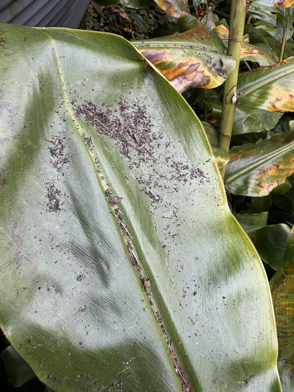
January 25, 2026 — Pele's hair and ash on a ginger leaf in Volcano after Kīlauea episode 41
January 25, 2026 — Pele's hair and ash on a ginger leaf in Volcano after Kīlauea episode 41Photo of broken pieces of reticulite, fine ash, and Pele's hair on a ginger leaf in the Volcano area, following episode 41 of lava fountaining on January 24, 2026. This photo was taken at a residence about 7.3 km (4.5 miles) away from the eruptive vents in Halemaʻumaʻu at the summit of Kīlauea.

Visualizing Land Cover with MRLC Tools
This video is a recording of a previous webinar entitled: “Visualizing Land Cover with MRLC Tools”. This webinar was recorded on January 20, 2026.
This video is a recording of a previous webinar entitled: “Visualizing Land Cover with MRLC Tools”. This webinar was recorded on January 20, 2026.
")
Top 5 Yellowstone geological stories of 2025 (Yellowstone monthly update - January 2026)
Top 5 Yellowstone geological stories of 2025 (Yellowstone monthly update - January 2026)Happy New Year! Let's go back and take a look at the top five geologic stories for Yellowstone in 2025.
Number five: Rumors. It was a year of internet rumors, mostly related to animals fleeing the park, and none of which were true.