Female McKay's Bunting with berry stained feathers
Female McKay's Bunting with berry stained feathersFemale McKay's Bunting with berry stained feathers on St. Matthew Island, Alaska.

Official websites use .gov
A .gov website belongs to an official government organization in the United States.
Secure .gov websites use HTTPS
A lock () or https:// means you’ve safely connected to the .gov website. Share sensitive information only on official, secure websites.
Access all multimedia to include images, video, audio, webcams, before-after imagery, and more. Filter and explore with filtering options to refine search.

Female McKay's Bunting with berry stained feathers on St. Matthew Island, Alaska.
Female McKay's Bunting with berry stained feathers on St. Matthew Island, Alaska.

This video describes how to use SAC-GUI in the field to plot high-water mark profiles. Plotting high-water marks in the field is required for most indirect measurement techniques
This video describes how to use SAC-GUI in the field to plot high-water mark profiles. Plotting high-water marks in the field is required for most indirect measurement techniques

This video describes the field selection of roughness coefficients, or Manning's "n" values. Both the comparative (photos) and analytical (Cowan's) methods are discussed.
This video describes the field selection of roughness coefficients, or Manning's "n" values. Both the comparative (photos) and analytical (Cowan's) methods are discussed.

Abnormally high spring rainfall and subsequent flooding in the Midwest in 2019 had a season-long impact on cropland production.
Abnormally high spring rainfall and subsequent flooding in the Midwest in 2019 had a season-long impact on cropland production.

This video describes how to survey high-water marks and cross-sections for indirect measurements. Included are tips and tricks for getting across non-wadeable sections of the stream.
This video describes how to survey high-water marks and cross-sections for indirect measurements. Included are tips and tricks for getting across non-wadeable sections of the stream.

Hydrologic Technician Dan Restivo of the USGS Washington Water Science Center admires the view while measuring discharge at the base of the South Cascade Glacier station 12181090 South Cascade Middle Tarn near Marblemount, WA.
Hydrologic Technician Dan Restivo of the USGS Washington Water Science Center admires the view while measuring discharge at the base of the South Cascade Glacier station 12181090 South Cascade Middle Tarn near Marblemount, WA.

Red fox kits on St. Matthew Island, Alaska
Red fox kits on St. Matthew Island, Alaska

Canada goose (Branta canadensis), Anchorage, AK
Canada goose (Branta canadensis), Anchorage, AK

Southwest-oriented view of the Bandera water supply tower near the Bandera County Courthouse, Bandera, Texas, December 2018 (photograph by Frank L. Engel, U.S. Geological Survey).
SIR 2019-5067
Southwest-oriented view of the Bandera water supply tower near the Bandera County Courthouse, Bandera, Texas, December 2018 (photograph by Frank L. Engel, U.S. Geological Survey).
SIR 2019-5067
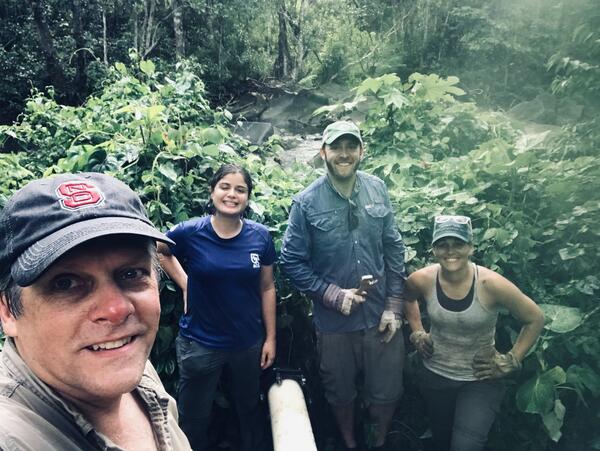
Dr. Tom Kwak, Dr. Gus Engman, Ámbar Torres Molinari, and Bonnie Myers working on rebuilding artificial streams to run experiments on native and non-native fish responses to extreme climate events.
Dr. Tom Kwak, Dr. Gus Engman, Ámbar Torres Molinari, and Bonnie Myers working on rebuilding artificial streams to run experiments on native and non-native fish responses to extreme climate events.
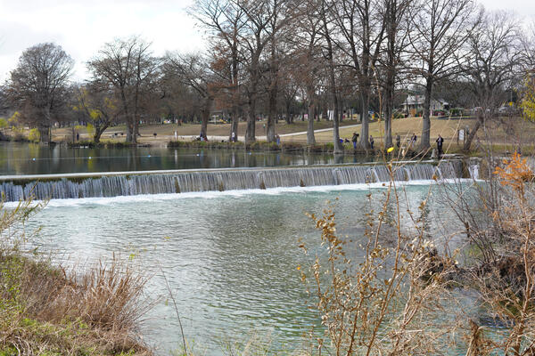
West-oriented view of the Medina River looking upstream near State Route 16 in Bandera, Texas, December 2018 (photograph by Frank L. Engel, U.S. Geological Survey).
SIR 2019-5067
West-oriented view of the Medina River looking upstream near State Route 16 in Bandera, Texas, December 2018 (photograph by Frank L. Engel, U.S. Geological Survey).
SIR 2019-5067

This video goes into detail about where to flag high-water marks and how to survey a slope-area measurement. A simple one-setup Total Station survey is demonstrated.
This video goes into detail about where to flag high-water marks and how to survey a slope-area measurement. A simple one-setup Total Station survey is demonstrated.

This video covers the theory behind a slope-area indirect measurement, the most common type of indirect measurement used in the USGS.
This video covers the theory behind a slope-area indirect measurement, the most common type of indirect measurement used in the USGS.

Lesser Snow Geese are captured using a helicopter to herd them into large pens to await banding.
Lesser Snow Geese are captured using a helicopter to herd them into large pens to await banding.

A Black-legged Kittiwake with two chicks at Gull Island, Alaska.
A Black-legged Kittiwake with two chicks at Gull Island, Alaska.

Northern Fulmars, Black-legged Kittiwakes, and Common Murres have all been tested for and contained harmful algal bloom (HAB) toxins in Alaska. Since 2015, the USGS has worked with a variety of stakeholders to develop testing methods and research projects to better understand the geographic extent, timing and impacts of algal toxins in Alaska marine ecosystems.
Northern Fulmars, Black-legged Kittiwakes, and Common Murres have all been tested for and contained harmful algal bloom (HAB) toxins in Alaska. Since 2015, the USGS has worked with a variety of stakeholders to develop testing methods and research projects to better understand the geographic extent, timing and impacts of algal toxins in Alaska marine ecosystems.

This video is a recording of the webinar “Climate Projections as a Way to Illustrate Future Possibilities" that is part of the USGS National Climate Adaptation Science Center (NCASC), in partnership with the National Conservation Training Center (NCTC), 2019 webinar series.
This video is a recording of the webinar “Climate Projections as a Way to Illustrate Future Possibilities" that is part of the USGS National Climate Adaptation Science Center (NCASC), in partnership with the National Conservation Training Center (NCTC), 2019 webinar series.

Telephoto views of water in the bottom of Halema‘uma‘u taken during a helicopter lidar survey on July 25, 2019 (left), when the pond was first observed, and a USGS overflight on August 1, 2019 (right). The pond grew slightly in size and depth between the two dates; an "X" marks the same rock in both photos for comparison.
Telephoto views of water in the bottom of Halema‘uma‘u taken during a helicopter lidar survey on July 25, 2019 (left), when the pond was first observed, and a USGS overflight on August 1, 2019 (right). The pond grew slightly in size and depth between the two dates; an "X" marks the same rock in both photos for comparison.

Lesser Snow Geese are captured using a helicopter to herd them into large pens to await banding.
Lesser Snow Geese are captured using a helicopter to herd them into large pens to await banding.

Title: Taking the Pulse of our Planet: A 10-year status report from the USA National Phenology Network
Title: Taking the Pulse of our Planet: A 10-year status report from the USA National Phenology Network

USGS field biologist Andrea Mott displays a recently marked Lesser Snow Goose.
USGS field biologist Andrea Mott displays a recently marked Lesser Snow Goose.