



Kankakee River at Davis, IN - gage
All Multimedia
Access all multimedia to include images, video, audio, webcams, before-after imagery, and more. Filter and explore with filtering options to refine search.
Filter Total Items: 24981

Kankakee River at Davis, IN - gage

Kankakee River at Davis, IN - fall photo
Kankakee River at Davis, IN - fall photo

Kīlauea Volcano — Drone Over Lava Channel
USGS Mavic Pro drone image of the fissure 8 lava channel looking toward the vent. Overflows can be seen as incandescent spots beyond the channel margins. Drone flights and resultant imagery help scientists better identify areas of channel overflows and active flow advancement.
USGS Mavic Pro drone image of the fissure 8 lava channel looking toward the vent. Overflows can be seen as incandescent spots beyond the channel margins. Drone flights and resultant imagery help scientists better identify areas of channel overflows and active flow advancement.

Kīlauea Volcano — Fissure 8 Channel (Annotated)
Annotated drone image of Kīlauea Volcano's lower East Rift Zone fissure 8 lava channel. Image captured near Kapoho Crater looking east toward the ocean entry. Incandescent flow margin is more easily identified in the dark - specifically here in the area of Kapoho Beach Lots.
Annotated drone image of Kīlauea Volcano's lower East Rift Zone fissure 8 lava channel. Image captured near Kapoho Crater looking east toward the ocean entry. Incandescent flow margin is more easily identified in the dark - specifically here in the area of Kapoho Beach Lots.

Kīlauea Volcano — Lava at Kapoho Beach Lots
At the coast, the northern margin of the flow field is still oozing pasty lava at several points in the area of Kapoho Beach Lots.
At the coast, the northern margin of the flow field is still oozing pasty lava at several points in the area of Kapoho Beach Lots.

Kīlauea Volcano — Ocean Entry
The ocean entry being fed by a crusted over channel has fewer tiny ooze-out channels than yesterday spilling into the water. One larger ooze-out channel making dominant entry plume at the northern end of the broad ocean entry.
The ocean entry being fed by a crusted over channel has fewer tiny ooze-out channels than yesterday spilling into the water. One larger ooze-out channel making dominant entry plume at the northern end of the broad ocean entry.

Kīlauea Volcano — Open Lava Channels
Fountains from Fissure 8 spatter cone continue to supply lava to the open channel with intermittent small, short-lived overflows. Overflows appear as lighter gray to silver areas on the margins of the channel.
Fountains from Fissure 8 spatter cone continue to supply lava to the open channel with intermittent small, short-lived overflows. Overflows appear as lighter gray to silver areas on the margins of the channel.

Kīlauea Volcano — Overfows
Close up image of overflows from the fissure 8 lava channel. Photograph taken during the morning overflight.
Close up image of overflows from the fissure 8 lava channel. Photograph taken during the morning overflight.

Survey Requirements for Multiple Component Indirect Measurements
Survey Requirements for Multiple Component Indirect MeasurementsThis video describes the survey requirements for indirect measurements with multiple components, like flow going through a culvert and over a road on top of the culvert at the same time.
Survey Requirements for Multiple Component Indirect Measurements
Survey Requirements for Multiple Component Indirect MeasurementsThis video describes the survey requirements for indirect measurements with multiple components, like flow going through a culvert and over a road on top of the culvert at the same time.

Survey Requirements for Road Overflow Indirect Measurements
Survey Requirements for Road Overflow Indirect MeasurementsIn this video, you will learn what and where to survey for a road overflow or broad-crested weir indirect measurement.
Survey Requirements for Road Overflow Indirect Measurements
Survey Requirements for Road Overflow Indirect MeasurementsIn this video, you will learn what and where to survey for a road overflow or broad-crested weir indirect measurement.

Basin Characterization Model: Future Scenarios for Indian Wells Valley
Basin Characterization Model: Future Scenarios for Indian Wells ValleyAnnual time series of precipitation and average air temperature for three future climate models for Indian Wells Valley, California as simulated by the Basin Characterization Model. Three future climate projections were selected from among 20 models used for California’s Fourth Climate Change Assessment for application to Indian Wells Valley.
Basin Characterization Model: Future Scenarios for Indian Wells Valley
Basin Characterization Model: Future Scenarios for Indian Wells ValleyAnnual time series of precipitation and average air temperature for three future climate models for Indian Wells Valley, California as simulated by the Basin Characterization Model. Three future climate projections were selected from among 20 models used for California’s Fourth Climate Change Assessment for application to Indian Wells Valley.

Kīlauea Volcano — Collapse/Explosion Event at Halema‘uma‘u
Kīlauea Volcano — Collapse/Explosion Event at Halema‘uma‘u
Kīlauea Volcano — Whirlwind Above Fissure 8
In the Leilani Estates subdivision, Hawaiian Volcano Observatory field crews monitoring fissure 8 captured this video of a whirlwind above the lava channel.
In the Leilani Estates subdivision, Hawaiian Volcano Observatory field crews monitoring fissure 8 captured this video of a whirlwind above the lava channel.

Mokelumne River Bathymetry
A winding strip of rainbow colors shows the bathymetry (depth) of the bed of the Mokelumne River just above its confluence with the San Joaquin in the Sacramento-San Joaquin River Delta east of San Francisco Bay.
A winding strip of rainbow colors shows the bathymetry (depth) of the bed of the Mokelumne River just above its confluence with the San Joaquin in the Sacramento-San Joaquin River Delta east of San Francisco Bay.
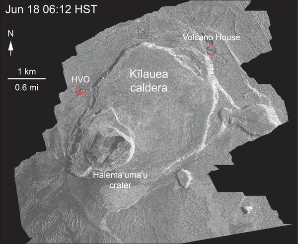
Kīlauea Volcano — Animation of Summit Drop
This animated GIF shows a sequence of radar amplitude images that were acquired by the Agenzia Spaziale Italiana CosmoSkyMed satellite system. The images illustrate changes to the caldera area of Kīlauea Volcano that occurred between May 5 and June 30 at about 6:00 a.m. HST.
This animated GIF shows a sequence of radar amplitude images that were acquired by the Agenzia Spaziale Italiana CosmoSkyMed satellite system. The images illustrate changes to the caldera area of Kīlauea Volcano that occurred between May 5 and June 30 at about 6:00 a.m. HST.

Kīlauea Volcano — Fissure 8
Fountains from the fissure 8 spatter cone continue to supply lava to an open channel.
Fountains from the fissure 8 spatter cone continue to supply lava to an open channel.

Kīlauea Volcano — Kapoho Coast
At the Kapoho coast, lava enters the ocean along the northern margin of the flow field.
At the Kapoho coast, lava enters the ocean along the northern margin of the flow field.

Kīlauea Volcano — Lava Channels from Fissure 8
Lava from fissure 8 is fed into a channel that travels about 13 km (8 mi) to the sea. A plumemarks the location of fissure 8, visible in the upper right; a small plume in the upper center marks the location of fissure 22.
Lava from fissure 8 is fed into a channel that travels about 13 km (8 mi) to the sea. A plumemarks the location of fissure 8, visible in the upper right; a small plume in the upper center marks the location of fissure 22.

Kīlauea Volcano — Lava Flowing Around Channel Islands
Kīlauea Volcano — Lava Flowing Around Channel IslandsLava flows around islands in the lava channel. The direction of flow is from the upper right to lower left. Field crews can make a rough calculation of velocity by timing large blocks as they pass between two landmarks that are a known distance apart.
Kīlauea Volcano — Lava Flowing Around Channel Islands
Kīlauea Volcano — Lava Flowing Around Channel IslandsLava flows around islands in the lava channel. The direction of flow is from the upper right to lower left. Field crews can make a rough calculation of velocity by timing large blocks as they pass between two landmarks that are a known distance apart.

Kīlauea Volcano — Ocean Entry at Kapoho
Lava was entering the ocean over a broad area this morning. This image shows an active entry area along the northern flow front at Kapoho. View to the south.
Lava was entering the ocean over a broad area this morning. This image shows an active entry area along the northern flow front at Kapoho. View to the south.

Kīlauea Volcano — Summit Rockfalls
View of Kīlauea Volcano's summit. The brown visible dust coming from Halema‘uma‘u is from rockfalls.
View of Kīlauea Volcano's summit. The brown visible dust coming from Halema‘uma‘u is from rockfalls.