
USGS scientists measure biological soil crust cover in the study grassland.
Images
Explore our planet through photography and imagery, including climate change and water all the way back to the 1800s when the USGS was surveying the country by horse and buggy.
Filter Total Items: 21365

Grassland in Canyonlands National Park
USGS scientists measure biological soil crust cover in the study grassland.

Large blocks of failed coastal bluff on Barter Island
Large blocks of failed coastal bluff on Barter IslandLarge blocks of coastal bluff tumble down onto the beach of Barter Island, on the North Slope of Alaska.
Large blocks of failed coastal bluff on Barter Island
Large blocks of failed coastal bluff on Barter IslandLarge blocks of coastal bluff tumble down onto the beach of Barter Island, on the North Slope of Alaska.
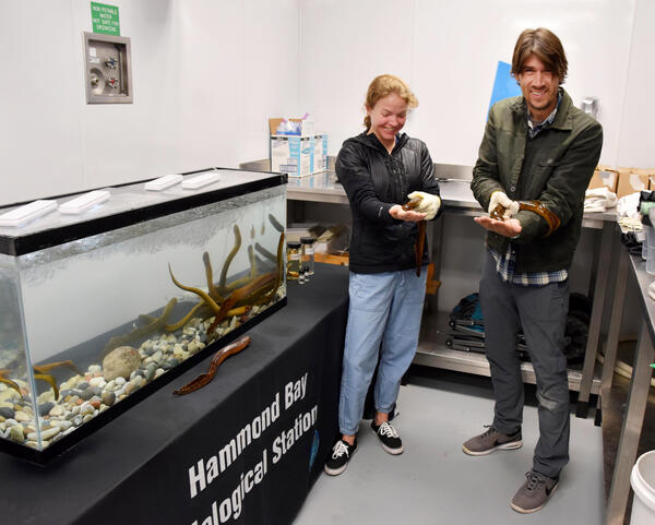
Live Sea Lamprey at the Hammond Bay Biological Station
Live Sea Lamprey at the Hammond Bay Biological StationNational Geographic photographer, Keith Ladzinski (right), and assistant, Angie Payne (left), hold live sea lamprey while visiting the GLSC’s Hammond Bay Biological Station during September 2019. An interview of Keith aired on Good Morning America on November 21, 2020, which included footage from their visit to the station. GLSC communications associate, Dr.

Low-oblique view of Barter Island bluffs
Example of a low-oblique photograph taken with an unmanned aerial system (UAS), or drone, of the coastal bluffs of Barter Island on North Slope of Alaska. The photographs from different time periods can be compared, using a technique called structure-from-motion photogrammetry, to measure changes in the coastal bluffs.
Example of a low-oblique photograph taken with an unmanned aerial system (UAS), or drone, of the coastal bluffs of Barter Island on North Slope of Alaska. The photographs from different time periods can be compared, using a technique called structure-from-motion photogrammetry, to measure changes in the coastal bluffs.
New Technology for Scanning Sediment
(Left) EPA and Kent State University scientists (left-to-right), Dr. Janet Nestlerode, Taylor Michael, and Dr. Elizabeth Hinchey, on the R/V Muskie with the SPI cam. (Right) High-resolution image of a cross-section of the sediment including the sediment water interface to ~25 cm below surface from a site in the central basin of Lake Erie.
(Left) EPA and Kent State University scientists (left-to-right), Dr. Janet Nestlerode, Taylor Michael, and Dr. Elizabeth Hinchey, on the R/V Muskie with the SPI cam. (Right) High-resolution image of a cross-section of the sediment including the sediment water interface to ~25 cm below surface from a site in the central basin of Lake Erie.

Oblique view of Barter Island bluffs
Example of a high-oblique photograph taken with an unmanned aerial system (UAS), or drone, of the coastal bluffs of Barter Island on North Slope of Alaska. The photographs from different time periods can be compared, using a technique called structure-from-motion photogrammetry, to measure changes in the coastal bluffs.
Example of a high-oblique photograph taken with an unmanned aerial system (UAS), or drone, of the coastal bluffs of Barter Island on North Slope of Alaska. The photographs from different time periods can be compared, using a technique called structure-from-motion photogrammetry, to measure changes in the coastal bluffs.

Polar bear print
Cordell Johnson holds his hand next to a polar bear's footprint.
Cordell Johnson holds his hand next to a polar bear's footprint.

Seismic sled used for sub-bottom surveying
USGS scientist Chelsea Stalk stands on a floating sled that enables sub‐bottom surveying in shallow water, nearshore, and shore‐face environments. The sled is equipped with an EdgeTech SB‐512i CHIRP system and single‐beam sonar. This equipment is used to collect seismic sub‐bottom profiles and single‐beam bathymetry.
USGS scientist Chelsea Stalk stands on a floating sled that enables sub‐bottom surveying in shallow water, nearshore, and shore‐face environments. The sled is equipped with an EdgeTech SB‐512i CHIRP system and single‐beam sonar. This equipment is used to collect seismic sub‐bottom profiles and single‐beam bathymetry.

Thermal photograph of Barter Island bluffs
Example of a thermal photograph of Barter Island's bluffs, on the North Slope of Alaska. Two USGS scientists stand waving on the right side of the photo. Lighter areas are warmer, darker areas are colder. Thermal photography makes it easy to detect areas of permafrost, or the lack thereof.
Example of a thermal photograph of Barter Island's bluffs, on the North Slope of Alaska. Two USGS scientists stand waving on the right side of the photo. Lighter areas are warmer, darker areas are colder. Thermal photography makes it easy to detect areas of permafrost, or the lack thereof.

USGS PCMSC UAS
An remotely piloted aircraft (RPA) or drone, equipped with a camera, sits on the Arctic tundra awaiting a radio signal that tells it to fly.
An remotely piloted aircraft (RPA) or drone, equipped with a camera, sits on the Arctic tundra awaiting a radio signal that tells it to fly.

Using unique methods to measure nearshore and coastal geology
Using unique methods to measure nearshore and coastal geologyUSGS scientists use specialized equipment to measure sediment dynamics in nearshore and coastal systems. Access by boat is limited in these areas, so personal watercraft are equipped with GPS and echosounders to collect bathymetric data. Seismic sleds are pulled along transects from the beach across the water to measure changes in sediment type below the water.

Fume Hood in Carbon Lab
Horiba Aqaulog - simultaneously measures absorbance spectra and fluorescence Excitation-Emission Matrices
Horiba Aqaulog - simultaneously measures absorbance spectra and fluorescence Excitation-Emission Matrices

USGS wildlife biologist piloting an UAS for use in walrus survey
USGS wildlife biologist piloting an UAS for use in walrus surveyUSGS wildlife biologist, Anthony Fischbach, piloting an unmanned aerial system (UAS) for use in surveying walruses while they rest on shore. The UAS is flown above 300 feet altitude such that it enables survey data collection with minimal risk to the walruses.

Another timelapse view of the summit water pond
This timelapse video covers about 30 minutes of activity at the water pond in Halema‘uma‘u at the summit of Kīlauea. Water appears to be flowing into the pond from several locations, including the southern boundary (right side in this image). A small amount of material is also seen floating on the surface at the eastern end of the pond (top of image).
This timelapse video covers about 30 minutes of activity at the water pond in Halema‘uma‘u at the summit of Kīlauea. Water appears to be flowing into the pond from several locations, including the southern boundary (right side in this image). A small amount of material is also seen floating on the surface at the eastern end of the pond (top of image).

Flora and Fauna - Cottonwoods Galleries
Both Powell’s crew and this year’s modern expedition camped along the river with views of cottonwood galleries.
Both Powell’s crew and this year’s modern expedition camped along the river with views of cottonwood galleries.

Flora and Fauna - Emerging Aquatic Insects
USGS scientists collected the adult life stage of emerging aquatic insects each evening of the recent Sesquicentennial Colorado River Exploring Expedition.
USGS scientists collected the adult life stage of emerging aquatic insects each evening of the recent Sesquicentennial Colorado River Exploring Expedition.

HVO measures water table at Keller Well
HVO field engineers and staff conducted quarterly work at a deep borehole, known as the Keller Well, at the summit of Kīlauea Volcano today (Sept. 24). They lowered a sensor into the well to measure the distance between the ground surface and the top of the water table, which was 505 m (1657 ft) below the ground surface today.
HVO field engineers and staff conducted quarterly work at a deep borehole, known as the Keller Well, at the summit of Kīlauea Volcano today (Sept. 24). They lowered a sensor into the well to measure the distance between the ground surface and the top of the water table, which was 505 m (1657 ft) below the ground surface today.

Pacific walruses in water jousting with their tusks, Alaska
Pacific walruses in water jousting with their tusks, AlaskaPacific walruses jousting with their tusks on the eastern shore of the Chukchi Sea, Alaska (Photo taken during USGS research efforts permitted under US Fish and Wildlife Service Permit No. MA801652-7.)

Pacific walruses on beach and in water, Chukchi Sea, Alaska
Pacific walruses on beach and in water, Chukchi Sea, AlaskaPacific walruses resting on the beach of the eastern shore of the Chukchi Sea (Photo taken during USGS research efforts permitted under US Fish and Wildlife Service Permit No. MA801652-7.)

Scientists track Hurricane Dorian effects on Low Country Coast
Scientists track Hurricane Dorian effects on Low Country CoastA storm-tide sensor deployed on Florida's Indian River Lagoon, at Indian River Drive in St. Lucie County, on Aug. 30, 2019 in preparation for Hurricane Dorian. NOTE: Though the story is about the Carolinas, the photo is from Florida. No photos of the Carolinas deployment were available at the time this story was published.

USGS biologist piloting an UAS for Pacific walrus survey, Alaska
USGS biologist piloting an UAS for Pacific walrus survey, AlaskaUSGS wildlife biologist, Anthony Fischbach, piloting an unmanned aerial system (UAS) for use in surveying walruses while they rest on shore. The UAS is flown above 300 feet altitude such that it enables survey data collection with minimal risk to the walruses.