
The last night, as we neared Desolation Canyon, the bluffs got taller. Since the Green River is calmer here, it reflected the colors of the sunset. I was so worried about making it before the sun went down that I climbed the peak in my chaco sandals, a decision I regretted the next day since my foot were banged up.
Images
Explore our planet through photography and imagery, including climate change and water all the way back to the 1800s when the USGS was surveying the country by horse and buggy.
Filter Total Items: 21365

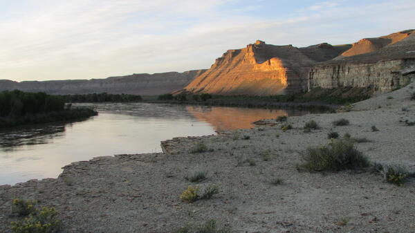
The last camp sunset over the Green River
The last night, as we neared Desolation Canyon, the bluffs got taller. Since the Green River is calmer here, it reflected the colors of the sunset. I was so worried about making it before the sun went down that I climbed the peak in my chaco sandals, a decision I regretted the next day since my foot were banged up.

The photo above has been cropped here to better show agitation on the pond surfa
The photo above has been cropped here to better show agitation on the pond surfaThe photo above has been cropped here to better show agitation on the pond surface. The agitation could be due to escaping gases from below rising through the water, or from the water boiling, or, perhaps, a combination of both.

View of the boats and river from a lunch hike vista
View of the boats and river from a lunch hike vistaMost of our views were from the river level, where you are intimately connected to subtleties in flow, wind, and temperature. It was a welcome opportunity to view the river from above and gain context. We stopped here on the last full day on the river.

We find rock art from prehistoic peoples during a lunch stop.
We find rock art from prehistoic peoples during a lunch stop.These lands have never been empty, although in some places it feels that way. Before western settlers arrived, these lands were polulated by other peoples throughout prehistory. Tom McKinley estimates that these images were drawn during the Fremont age. Some images are clearly human, one may be a fish, others are less clear.

Beaver lodge and drained impoundment in tributary of the Noatak River
Beaver lodge and drained impoundment in tributary of the Noatak RiverBeaver lodge and drained impoundment in tributary of the Noatak River, Noatak National Preserve
Beaver lodge and drained impoundment in tributary of the Noatak River
Beaver lodge and drained impoundment in tributary of the Noatak RiverBeaver lodge and drained impoundment in tributary of the Noatak River, Noatak National Preserve

Electrofishing on Eighteenmile Creek, NY
A USGS field crew captures fish during a boat electrofishing survey
A USGS field crew captures fish during a boat electrofishing survey

Impounded water above beaver dam on the Wrench Creek
Impounded water above beaver dam on the Wrench CreekImpounded water above beaver dam on the Wrench Creek, Noatak National Preserve
Impounded water above beaver dam on the Wrench Creek
Impounded water above beaver dam on the Wrench CreekImpounded water above beaver dam on the Wrench Creek, Noatak National Preserve

CMHRP investigations help protect natural and cultural resources
CMHRP investigations help protect natural and cultural resourcesThe CMHRP has been conducting scientific investigations at Fire Island in order to protect natural and cultural resources.
CMHRP investigations help protect natural and cultural resources
CMHRP investigations help protect natural and cultural resourcesThe CMHRP has been conducting scientific investigations at Fire Island in order to protect natural and cultural resources.

GCMRC sediment monitoring application landing page
GCMRC sediment monitoring application landing pageImage screen shot of GCMRC sediment monitoring application
GCMRC sediment monitoring application landing page
GCMRC sediment monitoring application landing pageImage screen shot of GCMRC sediment monitoring application

Littlefield Creek middle study site
Littlefield Creek middle study site

PCMSC research vessel Parke Snavely departs for deployment
PCMSC research vessel Parke Snavely departs for deploymentThe PCMSC research vessel R/V Parke Snavely heads out of the Vallejo Marina on June 11, 2019 to deploy instrument frames in Grizzly Bay for the ERO19 study.
PCMSC research vessel Parke Snavely departs for deployment
PCMSC research vessel Parke Snavely departs for deploymentThe PCMSC research vessel R/V Parke Snavely heads out of the Vallejo Marina on June 11, 2019 to deploy instrument frames in Grizzly Bay for the ERO19 study.

Photos before and after Hurricane Sandy opened a breach on Fire Island
Photos before and after Hurricane Sandy opened a breach on Fire IslandUSGS researchers have been monitoring changes in a breach in the island that occurred during Hurricane Sandy (modified from Hapke et al., 2017).
Photos before and after Hurricane Sandy opened a breach on Fire Island
Photos before and after Hurricane Sandy opened a breach on Fire IslandUSGS researchers have been monitoring changes in a breach in the island that occurred during Hurricane Sandy (modified from Hapke et al., 2017).

A tent is pitched on a ledge overlooking the Green River.
A tent is pitched on a ledge overlooking the Green River.This was our final campsite before we left the river, approximately 9 miles upstream of Sand Wash. The scenery was beginning to transition from the flat and expansive Uinta basin to the high canyon walls that were upcoming in Desolation-Gray.

Fernhill Sample Site 18
View of lake at Fernhill Natural Treatment Wetlands.
View of lake at Fernhill Natural Treatment Wetlands.

Six rafts are parked by the river's edge, getting loaded down with sup
Six rafts are parked by the river's edge, getting loaded down with supWe camped on a 20-30 ft. tall hill our last night, so shuttling kitchen gear up and down from the rafts was no easy task.
Six rafts are parked by the river's edge, getting loaded down with sup
Six rafts are parked by the river's edge, getting loaded down with supWe camped on a 20-30 ft. tall hill our last night, so shuttling kitchen gear up and down from the rafts was no easy task.

Sunrise in canyon country from our last campsite
Early morning panorama of cliffs that signal the start of Desolation Canyon. This was our last, and probably most spectacular, campsite of this section of Uinta Basin. It was approximately 9 miles from our take-out at Sand Wash.
Early morning panorama of cliffs that signal the start of Desolation Canyon. This was our last, and probably most spectacular, campsite of this section of Uinta Basin. It was approximately 9 miles from our take-out at Sand Wash.
Sunrise lights the bluffs as this expedition leg nears its end.
Sunrise lights the bluffs as this expedition leg nears its end.On our last day of the expedition the landscape was dominated by the Green River Formation, famous for its fish fossils (although none were found in camp).
Sunrise lights the bluffs as this expedition leg nears its end.
Sunrise lights the bluffs as this expedition leg nears its end.On our last day of the expedition the landscape was dominated by the Green River Formation, famous for its fish fossils (although none were found in camp).

The last sunrise from my tent illuminates the nearby cliffs
The last sunrise from my tent illuminates the nearby cliffsThe final morning view from my text as the sun rose from the east and illuminated cliffs on the west. This trip was so wonderful and exceeded all of our expectations, it was hard to go back to reality.

Tripod preparation for ERO19
Lukas Winkler-Prins checks on the frame setup on June 10, 2019. This tripod has an RBR CTD, an RBR bursting pressure sensor, an RBR optical backscatter sensor, a LISST-200X, an altimeter, and two Nortek ADVs + Seapoint optical backscatter sensors, which will reveal information about water temperature and salinity, wave height and period, total s
Lukas Winkler-Prins checks on the frame setup on June 10, 2019. This tripod has an RBR CTD, an RBR bursting pressure sensor, an RBR optical backscatter sensor, a LISST-200X, an altimeter, and two Nortek ADVs + Seapoint optical backscatter sensors, which will reveal information about water temperature and salinity, wave height and period, total s

USGS Cascades Volcano Observatory staff, June 2019
USGS Cascades Volcano Observatory staff, June 2019USGS Cascades Volcano Observatory staff, June 2019
USGS Cascades Volcano Observatory staff, June 2019
USGS Cascades Volcano Observatory staff, June 2019USGS Cascades Volcano Observatory staff, June 2019

USGS scientist rowing a raft on the Green River.
Although we were all hoping it would never end, the final day on the river was a bittersweet reminder of the amazing experiences we had in the Uinta Basin.
Although we were all hoping it would never end, the final day on the river was a bittersweet reminder of the amazing experiences we had in the Uinta Basin.