
Alexa Van Eaton is a physical volcanologist at the U.S. Geological Survey Cascades Volcano Observatory.
Images
Volcano Hazard Program images.
Filter Total Items: 6274

Alexa Van Eaton
Alexa Van Eaton is a physical volcanologist at the U.S. Geological Survey Cascades Volcano Observatory.

Kīlauea summit monitoring data November 1, 2021, to January 22, 2022
Kīlauea summit monitoring data November 1, 2021, to January 22, 2022Plots showing the correlation between Kīlauea summit sulfur dioxide emissions (SO2) in tonnes per day (top panel), ground tilt in microradians (middle panel), and seismic tremor (RSAM) (lower panel) for the period of November 1, 2021, to January 22, 2022. Eruptive pauses and highly diminished activity are highlighted in blue. USGS plots.

Types of explosive clasts found at the summit of Mauna Loa
Types of explosive clasts found at the summit of Mauna LoaTypes of explosive clasts found in the debris fan deposits at the summit of Mauna Loa: (A) unaltered ponded lava flow, (B) unaltered pāhoehoe, (C) altered ponded lava flow, often has a red to pink hue, (D) thermally altered pāhoehoe, often has a red-to-pink hue, (E) gabbroic xenolith, the most crystalline rocks we found, (F) bread-crust outer surfaces and vesicular

Map of explosive deposits at the edge of Moku‘āweoweo, the summit caldera of Mauna Loa.
Map of explosive deposits at the edge of Moku‘āweoweo, the summit caldera of Mauna Loa.Map of explosive deposits at the edge of Moku‘āweoweo, the summit caldera of Mauna Loa. Map showing the size distribution of ejecta, sorted by maximum length in centimeters (one inch is about 2.5 cm). The colors indicate the different size fractions in centimeters. The largest blocks were found closest to the rim.

Seismicity in the Yellowstone region during 2021
Map of seismicity (red circles) in the Yellowstone region during 2021. Gray lines are roads, black dashed line shows the caldera boundary, Yellowstone National Park is outlined by black dot-dashed line, and gray dashed lines denote state boundaries.
Map of seismicity (red circles) in the Yellowstone region during 2021. Gray lines are roads, black dashed line shows the caldera boundary, Yellowstone National Park is outlined by black dot-dashed line, and gray dashed lines denote state boundaries.

Michael Randall
Michael Randall is a software engineer who develops applications to view volcanic monitoring data for the USGS Volcano Science Center.
Michael Randall is a software engineer who develops applications to view volcanic monitoring data for the USGS Volcano Science Center.

Olivine in Hawaiian basalt
(L) Green olivine crystals in lava from Mauna Loa’s 1868 eruption. (R) Microscope image of a single olivine crystal extracted from tephra at Kīlauea. This crystal is about 1 mm (less than 1/16 of an inch) tall.
(L) Green olivine crystals in lava from Mauna Loa’s 1868 eruption. (R) Microscope image of a single olivine crystal extracted from tephra at Kīlauea. This crystal is about 1 mm (less than 1/16 of an inch) tall.
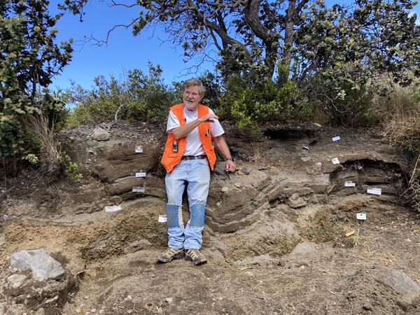
Don Swanson describing Keanakāko‘i Tephra deposits
Don Swanson describing Keanakāko‘i Tephra depositsDon Swanson describes the stratigraphy of Keanakāko‘i deposits near Uēkahuna Bluff at Kīlauea summit within Hawai‘i Volcanoes National Park.
Don Swanson describing Keanakāko‘i Tephra deposits
Don Swanson describing Keanakāko‘i Tephra depositsDon Swanson describes the stratigraphy of Keanakāko‘i deposits near Uēkahuna Bluff at Kīlauea summit within Hawai‘i Volcanoes National Park.

Boiling River near Mammoth Hot Springs, Yellowstone National Park
Boiling River near Mammoth Hot Springs, Yellowstone National ParkBoiling River near Mammoth Hot Springs, Yellowstone National Park. Photo by R. Robinson.
Boiling River near Mammoth Hot Springs, Yellowstone National Park
Boiling River near Mammoth Hot Springs, Yellowstone National ParkBoiling River near Mammoth Hot Springs, Yellowstone National Park. Photo by R. Robinson.

Siliceous sinter in the field and viewed via Scanning Electron Microscope
Siliceous sinter in the field and viewed via Scanning Electron MicroscopeLeft photo shows a loose piece of siliceous sinter that was precipitated around a photosynthetic microbial mat in the Lower Geyser Basin. The microbial mat died when the outflow channel changed positions.

Castle Geyser features and Scanning Electron Microscope image of algal filament in a silica sheath
Castle Geyser features and Scanning Electron Microscope image of algal filament in a silica sheathOn the left is Castle Geyser during an eruption with a pool from nearby Tortoise Shell Spring showing photosynthetic pigments at the bottom. The middle image is of a small pool in the Geyser Hill Group in the Upper Geyser Basin with an outflow channel full of yellow, green, orange, red, and brown pigmented phototrophic microbial mats.
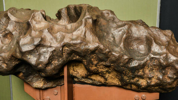
A 200-kilogram (440-pound) fragment of the Canyon Diablo meteorite that was found at Meteor Crater in Arizona
A 200-kilogram (440-pound) fragment of the Canyon Diablo meteorite that was found at Meteor Crater in ArizonaA 200-kilogram (440-pound) fragment of the Canyon Diablo meteorite that was found at Meteor Crater in Arizona.

2022 Volcano Awareness Month program calendar
Island of Hawai‘i Volcano Awareness Month 2022 calendar of programs, with descriptions.
Island of Hawai‘i Volcano Awareness Month 2022 calendar of programs, with descriptions.

Eruptive activity resumes at west vent in Halema‘uma‘u
Eruptive activity resumes at west vent in Halema‘uma‘uEruptive activity resumed today in Halema‘uma‘u crater, at the summit of Kīlauea volcano, after a brief pause of several days. This photograph shows spattering and lava effusion from the west vent, which has built a steep spatter cone. USGS image by M. Patrick.

Halemaʻumaʻu lava pond on December 30, 2021
During recent multi-day pauses in the ongoing Kīlauea summit eruption, a small portion of the Halemaʻumaʻu lava lake has consistently remained active: a small, ovular lava pond just north of the briefly dormant western fissure.
During recent multi-day pauses in the ongoing Kīlauea summit eruption, a small portion of the Halemaʻumaʻu lava lake has consistently remained active: a small, ovular lava pond just north of the briefly dormant western fissure.

Island of Hawai‘i seismicity
Two weeks of earthquake activity preceding the September 29, 2021, eruption at Kīlauea summit. The regions of interest indicated on the map include: KS (Kīlauea summit); ML (Mauna Loa summit); P (Pāhala).
Two weeks of earthquake activity preceding the September 29, 2021, eruption at Kīlauea summit. The regions of interest indicated on the map include: KS (Kīlauea summit); ML (Mauna Loa summit); P (Pāhala).

Lava lake topography during an eruption pause
On the afternoon of December 27, 2021, the summit eruption of Kīlauea was paused and showed only intermittent and weak crustal foundering in the formerly active west side of the lava lake in Halema‘uma‘u. This photo, looking down and toward the east, shows the topography of the formerly active pond of lava during the eruption pause.
On the afternoon of December 27, 2021, the summit eruption of Kīlauea was paused and showed only intermittent and weak crustal foundering in the formerly active west side of the lava lake in Halema‘uma‘u. This photo, looking down and toward the east, shows the topography of the formerly active pond of lava during the eruption pause.

[V1cam] image taken December 23, 2021
View of the west vent in Halemaʻumaʻu and the lava lake, from the northwest rim of the caldera, looking east [V1cam]. Image taken December 23, 2021.
View of the west vent in Halemaʻumaʻu and the lava lake, from the northwest rim of the caldera, looking east [V1cam]. Image taken December 23, 2021.

Hannah Kruse
Hannah Kruse is a geologist with the USGS USAID Volcano Disaster Assistance Program who focuses on volcanic eruption chronologies past and present.
Hannah Kruse is a geologist with the USGS USAID Volcano Disaster Assistance Program who focuses on volcanic eruption chronologies past and present.

Laura Clor
Laura Clor is a gas geochemist who works with the five U.S. Geological Survey volcano observatories.
Laura Clor is a gas geochemist who works with the five U.S. Geological Survey volcano observatories.

Christopher Harpel
Christopher Harpel is a geologist with the USGS-USAID Volcano Disaster Assistance Program.
Christopher Harpel is a geologist with the USGS-USAID Volcano Disaster Assistance Program.