U.S. flag

An official website of the United States government

Multimedia

The USGS Volcano Observatories host videos, photos, web camera views, and sometimes podcasts to share visual and audio information about volcanic eruptions and volcanic processes. 

Images

Wide aerial view of Kīlauea summit caldera
March 14, 2025—Kīlauea summit eruption overflight

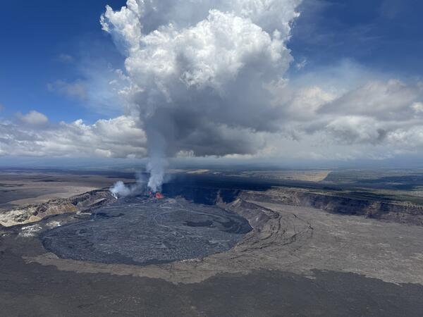
Hawaiian Volcano Observatory geologists captured this aerial view of Kīlauea summit on March 14, 2025, during a helicopter overflight. Three days after the end of episode 13 of the ongoing eruption, the north and south cones are degassing in the southwest corner of Halema‘uma‘u.

Hawaiian Volcano Observatory geologists captured this aerial view of Kīlauea summit on March 14, 2025, during a helicopter overflight. Three days after the end of episode 13 of the ongoing eruption, the north and south cones are degassing in the southwest corner of Halema‘uma‘u.

A wide aerial view of the summit caldera (Kaluapele) at Kīlauea volcano
March 14, 2025 —Aerial view of Kīlauea summit

A wide aerial view of the summit caldera (Kaluapele) at Kīlauea volcano, showing recent lava flows (center of photo) filling the deepest portion of Halema‘uma‘u crater. The white outgassing plume from the recently active vents is carried to the southwest in the tradewinds.

A wide aerial view of the summit caldera (Kaluapele) at Kīlauea volcano, showing recent lava flows (center of photo) filling the deepest portion of Halema‘uma‘u crater. The white outgassing plume from the recently active vents is carried to the southwest in the tradewinds.

A view of Halema‘uma‘u and the downdropped block
March 14, 2025 —Aerial view of Halema‘uma‘u crater

A closer view of Halema‘uma‘u and the downdropped block, within the deepest portion of Kīlauea's summit caldera. Lava flows have crept eastward (towards bottom left in photo) as the crater floor rises with recent infilling. USGS photo taken on March 14, 2025, by M. Patrick.

A closer view of Halema‘uma‘u and the downdropped block, within the deepest portion of Kīlauea's summit caldera. Lava flows have crept eastward (towards bottom left in photo) as the crater floor rises with recent infilling. USGS photo taken on March 14, 2025, by M. Patrick.

A white plume of volcanic gas rises from a volcanic vent in a crater
March 14, 2025 — Kīlauea summit eruption overflight with Mauna Loa in the background

A low-angle aerial view of the vents where episodic fountaining has been occurring since the start of the ongoing Kīlauea summit eruption on December 23, 2024. A white plume of volcanic gas rises from the north vent (center right) and south vent (center left) cones in the southwest corner of Halema‘uma‘u crater, as viewed during a monitoring overflight.

A low-angle aerial view of the vents where episodic fountaining has been occurring since the start of the ongoing Kīlauea summit eruption on December 23, 2024. A white plume of volcanic gas rises from the north vent (center right) and south vent (center left) cones in the southwest corner of Halema‘uma‘u crater, as viewed during a monitoring overflight.

Close up aerial view of the north vent cone degassing in the southwest corner of Halema‘uma‘u
March 14, 2025 — Kīlauea eruption remains on pause during summit overflight

On the morning of March 14, USGS Hawaiian Volcano Observatory scientists conducted an overflight of Kīlauea summit to capture thermal and surficial imagery of the ongoing (paused) eruption. Three days after the end of episode 13, this telephoto aerial view shows the north cone degassing in the southwest corner of Halema‘uma‘u.

On the morning of March 14, USGS Hawaiian Volcano Observatory scientists conducted an overflight of Kīlauea summit to capture thermal and surficial imagery of the ongoing (paused) eruption. Three days after the end of episode 13, this telephoto aerial view shows the north cone degassing in the southwest corner of Halema‘uma‘u.

Brown volcanic cones partially buried by recent solidified black lava flows
March 14, 2025 —Aerial view of September 2023 Kīlauea cones

On the morning of March 14, USGS Hawaiian Volcano Observatory scientists conducted a monitoring overflight of Kīlauea. This aerial view shows cones formed during the September 2023 eruption, surrounded and partially buried by lava erupted within the past few weeks during the ongoing (and currently paused) eruption within Halema‘uma‘u. USGS photo by N. Deligne.

On the morning of March 14, USGS Hawaiian Volcano Observatory scientists conducted a monitoring overflight of Kīlauea. This aerial view shows cones formed during the September 2023 eruption, surrounded and partially buried by lava erupted within the past few weeks during the ongoing (and currently paused) eruption within Halema‘uma‘u. USGS photo by N. Deligne.

Videos

Phot of Cleveland Volcano in eruption and title of presentation by J. Lowenstern The Challenge of Volcano Monitoring, Eruption Forecasting, and Protecting Vulnerable Populations
The Challenge of Volcano Monitoring, Eruption Forecasting, and Protecting Vulnerable Populations

This presentation by Dr. Jake Lowenstern was prepared for the AGU 2024-2025 Distinguished Lecture Series. It discusses the challenges of volcano monitoring, eruption forecasting, and protecting vulnerable populations.

This presentation by Dr. Jake Lowenstern was prepared for the AGU 2024-2025 Distinguished Lecture Series. It discusses the challenges of volcano monitoring, eruption forecasting, and protecting vulnerable populations.

Biscuit Basin Update, Hydrothermal Explosion on July 23, 2024 Biscuit Basin Hydrothermal Explosion Update (Yellowstone Monthly Update — October 2024)
Biscuit Basin Hydrothermal Explosion Update (Yellowstone Monthly Update — October 2024)

Let’s get you caught up on what we’ve learned about the July 23, 2024, hydrothermal explosion in Biscuit Basin, in this Yellowstone Volcano Observatory Monthly Update for October 2024. 

Read Caldera Chronicles

Let’s get you caught up on what we’ve learned about the July 23, 2024, hydrothermal explosion in Biscuit Basin, in this Yellowstone Volcano Observatory Monthly Update for October 2024. 

Read Caldera Chronicles

Is there oil in Yellowstone? Is there oil in Yellowstone? (Yellowstone Monthly Update - September 2024)
Is there oil in Yellowstone? (Yellowstone Monthly Update - September 2024)

Is it true that there's oil in Yellowstone? Watch this month's Yellowstone Monthly update and find out.

Morning Glory Pool Was Blue? Morning Glory Pool Was Blue? (Yellowstone Monthly Update - July 2024)
Morning Glory Pool Was Blue? (Yellowstone Monthly Update - July 2024)

The beautiful Morning Glory pool is located near Old Faithful. However, it has changed over time because of people and  past climate. But how? 

The beautiful Morning Glory pool is located near Old Faithful. However, it has changed over time because of people and  past climate. But how? 

A scientist is sitting in the lab, surrounded by volcano gas monitoring equipment, talking about his work. Gas Geochemistry and the USAID-USGS Volcano Disaster Assistance Program
Gas Geochemistry and the USAID-USGS Volcano Disaster Assistance Program

The purpose of the USAID USGS Volcano Disaster Assistance Program is to make sure that volcanic eruptions don't become volcanic disasters. VDAP’s focus is to support volcano observatories through a combination of in-country or virtual support during volcanic eruptions or unrest and long-term capacity building through donations and training.

The purpose of the USAID USGS Volcano Disaster Assistance Program is to make sure that volcanic eruptions don't become volcanic disasters. VDAP’s focus is to support volcano observatories through a combination of in-country or virtual support during volcanic eruptions or unrest and long-term capacity building through donations and training.

Swimming Pools at Yellowstone? Swimming Pools at Yellowstone? (Yellowstone Monthly Update - June 2024)
Swimming Pools at Yellowstone? (Yellowstone Monthly Update - June 2024)

Up until the 1950s, visitors to the Old Faithful area could take a dip. Not at a geyser, but in a real swimming pool. The full story is in this month’s video update. 

Up until the 1950s, visitors to the Old Faithful area could take a dip. Not at a geyser, but in a real swimming pool. The full story is in this month’s video update. 

Audio

Kīlauea's Summit Vent Churns and Pops as Rocks Fall Into the Lava L...
Kīlauea's Summit Vent Churns and Pops as Rocks Fall Into Lava Lake
Lava lake activity from inside Halema`uma`u Crater
Kīlauea's Summit Vent Churns and Pops as Rocks Fall Into the Lava L...
Kīlauea's Summit Vent Churns and Pops as Rocks Fall Into Lava Lake
Lava lake activity from inside Halema`uma`u Crater

Sounds of lava lake activity within Kilauea Volcano's summit vent inside Halema`uma`u Crater on the afternoon of February 14, 2011. The continuous "crashing wave" noise is the sound of churning lava as gases are released from the lake surface, which is in nearly constant motion.

Kīlauea's Summit Vent Churns and Pops as Rocks Fall Into the Lava L...
Kīlauea's Summit Vent Churns and Pops as Rocks Fall Into Lava Lake

Sounds of lava lake activity within Kilauea Volcano's summit vent inside Halema`uma`u Crater on the afternoon of February 14, 2011. The continuous "crashing wave" noise is the sound of churning lava as gases are released from the lake surface, which is in nearly constant motion.

CoreFacts
CoreFacts Album Artwork
How far did the ash from Mount St. Helens travel?
CoreFacts
CoreFacts Album Artwork
How far did the ash from Mount St. Helens travel?

Welcome to CoreFacts, where we're always short on time and big on science. I'm Brian Campbell. Today's question is …

How far did the ash from Mount St. Helens travel?

Welcome to CoreFacts, where we're always short on time and big on science. I'm Brian Campbell. Today's question is …

How far did the ash from Mount St. Helens travel?

USGS CoreCast
USGS CoreCast Series
Dramatic Developments at Kilauea Volcano
USGS CoreCast
USGS CoreCast Series
Dramatic Developments at Kilauea Volcano

Kilauea Volcano in Hawaii has experienced its first explosive eruption in more than 80 years and is now spewing noxious gas at 10 times the normal rate. John Eichelberger, head of the USGS Volcano Hazards Program, fills us in on the situation.

Kilauea Volcano in Hawaii has experienced its first explosive eruption in more than 80 years and is now spewing noxious gas at 10 times the normal rate. John Eichelberger, head of the USGS Volcano Hazards Program, fills us in on the situation.

Webcams

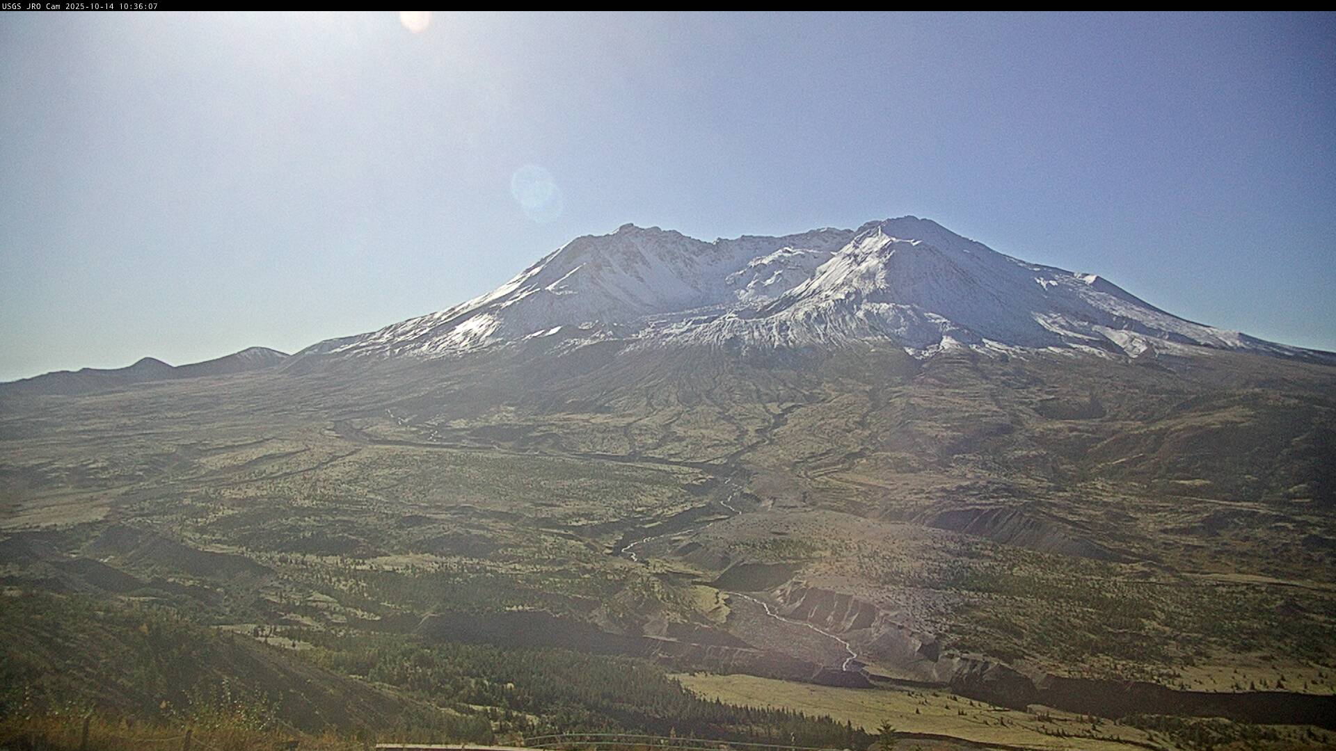
Image of Mount St. Helens looking south from the north of the volcano
Johnston Ridge Observatory, Mount St. Helens

This static image is from a USGS Cascades Volcano Observatory research camera located at the Johnston Ridge Observatory, north of Mount St. Helens.  The view is to the south.  This camera is intended to assist the USGS with situational awareness. At times, clouds, rain, and snow obscure visibility.

This static image is from a USGS Cascades Volcano Observatory research camera located at the Johnston Ridge Observatory, north of Mount St. Helens.  The view is to the south.  This camera is intended to assist the USGS with situational awareness. At times, clouds, rain, and snow obscure visibility.

Webcam image view of volcano flank
[HLcam] Live Image of Mauna Loa's northwest flank from Hualālai volcano
[HLcam] Live Image of Mauna Loa's northwest flank from Hualālai volcano
[HLcam] Live Image of Mauna Loa's northwest flank from Hualālai volcano

Live view of the northwest flank of Mauna Loa; the view is from the southeast flank of Hualālai [HLcam]. This camera is a pan-tilt-zoom model and the view may change depending on activity.

Live view of the northwest flank of Mauna Loa; the view is from the southeast flank of Hualālai [HLcam]. This camera is a pan-tilt-zoom model and the view may change depending on activity.

Live webcam view of lava erupting from Mauna Loa volcano
[MK2cam] Mauna Loa's Summit and Northeast Rift Zone from Mauna Kea
[MK2cam] Mauna Loa's Summit and Northeast Rift Zone from Mauna Kea
[MK2cam] Mauna Loa's Summit and Northeast Rift Zone from Mauna Kea

Live Image of Mauna Loa's Summit and Northeast Rift Zone from Mauna Kea [MK2cam]. This camera is a pan-tilt-zoom model and the view may change depending on activity.

Live Image of Mauna Loa's Summit and Northeast Rift Zone from Mauna Kea [MK2cam]. This camera is a pan-tilt-zoom model and the view may change depending on activity.

Webcam image view of volcanic vent in summit crater
[V1cam] Kīlauea volcano, Hawaii (west Halemaʻumaʻu crater)
[V1cam] Kīlauea volcano, Hawaii (west Halemaʻumaʻu crater)
[V1cam] Kīlauea volcano, Hawaii (west Halemaʻumaʻu crater)

Live view of Halemaʻumaʻu crater within Kaluapele (Kīlauea caldera), from the northwest rim of the crater [V1cam]. This camera is a pan-tilt-zoom model and the view may change depending on activity.

Disclaimer

Live view of Halemaʻumaʻu crater within Kaluapele (Kīlauea caldera), from the northwest rim of the crater [V1cam]. This camera is a pan-tilt-zoom model and the view may change depending on activity.

Disclaimer

This image is from a temporary research camera positioned just south of Puʻu ʻŌʻō, looking north at the southern flank of Puʻ
[PScam] Puʻu ʻŌʻō South Flank from the South Rim
[PScam] Puʻu ʻŌʻō South Flank from the South Rim
[PScam] Puʻu ʻŌʻō South Flank from the South Rim

This image is from a temporary research camera positioned just south of Puʻu ʻŌʻō, looking north at the southern flank of Puʻu ʻŌʻō's cone.


Disclaimer

This image is from a temporary research camera positioned just south of Puʻu ʻŌʻō, looking north at the southern flank of Puʻu ʻŌʻō's cone.


Disclaimer

View from webcam
[B1cam] - Kīlauea caldera down-dropped block and Halemaʻumaʻu
[B1cam] - Kīlauea caldera down-dropped block and Halemaʻumaʻu
[B1cam] - Kīlauea caldera down-dropped block and Halemaʻumaʻu

Live view of Kīlauea caldera down-dropped block and Halemaʻumaʻu crater from the east rim of the caldera.

Live view of Kīlauea caldera down-dropped block and Halemaʻumaʻu crater from the east rim of the caldera.

Was this page helpful?