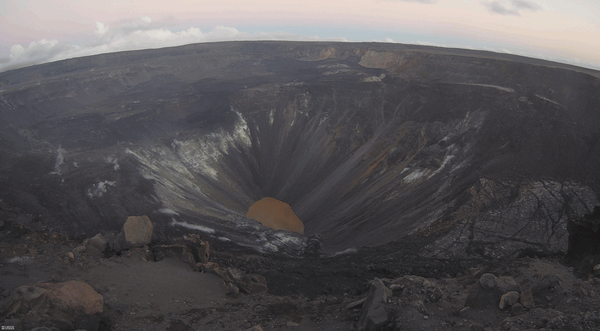
ANIMATED GIF: At Kīlauea summit, the KWcam webcam recorded several small color changes along the lake margin following rockfalls which impacted the lake surface. These rockfalls immediately followed a M3.1 earthquake Wednesday evening, December 2, at 5:59 p.m. HST. This animated image file (GIF) continuously loops two consecutive webcam images from 5:50 p.m.
Images
Volcano Hazard Program images.
ANIMATED GIF: At Kīlauea summit, the KWcam webcam recorded several small color changes along the lake margin following rockfalls which impacted the lake surface. These rockfalls immediately followed a M3.1 earthquake Wednesday evening, December 2, at 5:59 p.m. HST. This animated image file (GIF) continuously loops two consecutive webcam images from 5:50 p.m.
moon setting over Mauna Loa's broad Northeast Rift Zone
moon setting over Mauna Loa's broad Northeast Rift ZoneThis photo was taken from the west rim of Kīlauea caldera at dawn, and shows the moon setting over Mauna Loa's broad Northeast Rift Zone. USGS photo by M. Patrick.
moon setting over Mauna Loa's broad Northeast Rift Zone
moon setting over Mauna Loa's broad Northeast Rift ZoneThis photo was taken from the west rim of Kīlauea caldera at dawn, and shows the moon setting over Mauna Loa's broad Northeast Rift Zone. USGS photo by M. Patrick.
Tephra layers preserved at the summit of Kīlauea from at least three different eruptions. Deposits below the top of the scale are predominantly juvenile and deposits above it containing many lithics. Notice the larger size of the yellow pumice clasts compared to the much denser and finer grey lapilli and ash surrounding them from 7 to 18 on the scale.
Lidar hillshade map of part of the Blackfoot Volcanic Field
Lidar hillshade map of part of the Blackfoot Volcanic FieldLidar hillshade map of part of the Blackfoot Volcanic Field, showing rhyolite domes and fault scarps.
Lidar hillshade map of part of the Blackfoot Volcanic Field
Lidar hillshade map of part of the Blackfoot Volcanic FieldLidar hillshade map of part of the Blackfoot Volcanic Field, showing rhyolite domes and fault scarps.
Volcanic rocks in SE Idaho that are related to the Yellowstone hotspot
Volcanic rocks in SE Idaho that are related to the Yellowstone hotspotMap of southeastern Idaho showing volcanic rocks related to the Yellowstone hotspot. Basalt is shown in red and rhyolite in yellow. Blue circles indicate the location of past Yellowstone calderas; caldera names and approximate ages are shown (Ma = million years old).
Temperature records from sites on Yellowstone Lake bottom
Temperature records from sites on Yellowstone Lake bottomYear-long (August 2017 to August 2018) temperature records from two hydrothermal vents (“A” and “B”) in the Deep Hole area of Yellowstone Lake.
Temperature records from sites on Yellowstone Lake bottom
Temperature records from sites on Yellowstone Lake bottomYear-long (August 2017 to August 2018) temperature records from two hydrothermal vents (“A” and “B”) in the Deep Hole area of Yellowstone Lake.
Dark brown colors dominated the central and western portions of the lake at Kīlauea's summit. The greenish hues were present in areas that appear to be zone of hot water influx into the lake. USGS photo by M. Patrick.
A quick visit to the western caldera rim provided brief views of Kīlauea's summit lake between rain showers. The lake colors were particularly vibrant today, with a deep blue-green color in the western end (bottom of photo), with dark brown near the center. USGS photo by M. Patrick.
Map of Waiʻōhinu area, Island of Hawaiʻi, showing the location of the 3,740 year old age.
Upper Southwest Rift Zone of Kīlauea Volcano—October 22, 2020
Upper Southwest Rift Zone of Kīlauea Volcano—October 22, 2020View looking southwest along the Southwest Rift Zone of Kīlauea Volcano. The unvegetated nature of the Southwest Rift Zone is on full display with the Keanakākoʻi Tephra in the foreground overlying lava flows from Cone Peak (the cone in the middle ground to the right).
Old Faithful bathhouse during 1914-1933 (top) and 1934-1951 (bottom)
Old Faithful bathhouse during 1914-1933 (top) and 1934-1951 (bottom)Old Faithful bathhouse as it appeared in 1914-1933 (top) and 1934-1951 (bottom).
Old Faithful bathhouse during 1914-1933 (top) and 1934-1951 (bottom)
Old Faithful bathhouse during 1914-1933 (top) and 1934-1951 (bottom)Old Faithful bathhouse as it appeared in 1914-1933 (top) and 1934-1951 (bottom).
Photograph of Obsidian Cliff along Grand Loop Road between Norris and Mammoth Hot Springs. Photograph by John Good, U.S. National Park Service, 1965.
Yellowstone map with rhyolite eruptions highlighted
Yellowstone map with rhyolite eruptions highlightedMap of Yellowstone National Park adapted from Christiansen and others (2007). The pink regions are rhyolite flows erupted within Yellowstone caldera; these flows contain 5% to 15% crystals by volume. The purple region is the Obsidian Cliff flow, which contains close to 0% crystals.
Angular unconformity atop Mount Everts, Yellowstone National Park
Angular unconformity atop Mount Everts, Yellowstone National ParkAn unconformity at the top of Mount Everts is located where the Huckleberry Ridge Tuff, 2.1 million years old, lies directly on top of Cretaceous sediments that are ~60 million years old and greater. Right at the unconformity are conspicuous orange and black colors. The orange is oxidation of the sedimentary unit where it is in contact with the ash, whic
Highway 89 winding through Silver Gate in Yellowstone National Park
Highway 89 winding through Silver Gate in Yellowstone National ParkA few miles south of Mammoth Hot Springs in Yellowstone National Park, Highway 89 winds through the white/gray jumble of rocks known as the Hoodoos, or Silver Gate, that formed when travertine from Terrace Mountain collapsed in a landslide.
Silver Gate landslide complex in Yellowstone National Park
Silver Gate landslide complex in Yellowstone National ParkSilver Gate landslide complex in Yellowstone National Park. The jumbled nature of the calcium-carbonate rocks is evidence that the deposit was formed by collapse of a travertine hot-spring terrace that might once have looked like Mammoth Hot Springs does today.
Geophysicist checks data output at Mount Rainier station
Geophysicist checks data output at Mount Rainier stationA seismologist with the Cascades Volcano Observatory checks the data output on a newly installed monitoring station at Mount Rainier.
Geophysicist checks data output at Mount Rainier station
Geophysicist checks data output at Mount Rainier stationA seismologist with the Cascades Volcano Observatory checks the data output on a newly installed monitoring station at Mount Rainier.
Mount Rainier's seismic and infrasound station PARA
Mount Rainier's seismic and infrasound station PARASeismic and infrasound station PARA, installed October 6-8, 2020 at Mount Rainier.
Mount Rainier's seismic and infrasound station PARA
Mount Rainier's seismic and infrasound station PARASeismic and infrasound station PARA, installed October 6-8, 2020 at Mount Rainier.
A geophysicist notes location of new seismometer at Mount Rainier
A geophysicist notes location of new seismometer at Mount RainierA geophysicist from the Cascades Volcano Observatory notes the location of a newly buried seismometer at station PARA, on Mount Rainier.
A geophysicist notes location of new seismometer at Mount Rainier
A geophysicist notes location of new seismometer at Mount RainierA geophysicist from the Cascades Volcano Observatory notes the location of a newly buried seismometer at station PARA, on Mount Rainier.
NAGT intern installs infrasound sensors at Mount Rainier
NAGT intern installs infrasound sensors at Mount RainierNAGT intern Emily Bryant installs one of three infrasound sensors at volcano monitoring station PARA, at Mount Rainier.
NAGT intern installs infrasound sensors at Mount Rainier
NAGT intern installs infrasound sensors at Mount RainierNAGT intern Emily Bryant installs one of three infrasound sensors at volcano monitoring station PARA, at Mount Rainier.
Finishing the installation of seismic/GPS station YOCR, at Mount Hood
Finishing the installation of seismic/GPS station YOCR, at Mount HoodA USGS Cascades Volcano Observatory field team finishes the installation of the combined seismic/GPS station, YOCR, at Mount Hood, Oregon.
Finishing the installation of seismic/GPS station YOCR, at Mount Hood
Finishing the installation of seismic/GPS station YOCR, at Mount HoodA USGS Cascades Volcano Observatory field team finishes the installation of the combined seismic/GPS station, YOCR, at Mount Hood, Oregon.