USGS Cascades Volcano Observatory staff, June 2019
USGS Cascades Volcano Observatory staff, June 2019USGS Cascades Volcano Observatory staff, June 2019

Official websites use .gov
A .gov website belongs to an official government organization in the United States.
Secure .gov websites use HTTPS
A lock () or https:// means you’ve safely connected to the .gov website. Share sensitive information only on official, secure websites.
Volcano Hazard Program images.

USGS Cascades Volcano Observatory staff, June 2019
USGS Cascades Volcano Observatory staff, June 2019

During field observations on August 8, HVO scientists noted that all three ponds are now joined, indicating that the water at the bottom of Halema‘uma‘u continues to slowly rise. Rangefinder measurements also suggested continued pond deepening.
During field observations on August 8, HVO scientists noted that all three ponds are now joined, indicating that the water at the bottom of Halema‘uma‘u continues to slowly rise. Rangefinder measurements also suggested continued pond deepening.

Synchrotron X-Ray microtomography 3D image (a) and cathodoluminescence slice (b) from the same reentrant-bearing quartz crystal from the Lava Creek Tuff. The reentrants are in darker blue in (a) and the black cavities in (b). Note their relationship to quartz growth bands. Red domains are small magnetite crystals.
Synchrotron X-Ray microtomography 3D image (a) and cathodoluminescence slice (b) from the same reentrant-bearing quartz crystal from the Lava Creek Tuff. The reentrants are in darker blue in (a) and the black cavities in (b). Note their relationship to quartz growth bands. Red domains are small magnetite crystals.

Computer model of Lone Star Geyser constructed from multiple overlapping and scaled photographs and looking down into the geyser vent. This is a perspective that is only possible with images collected specifically to build a 3D model. Only the inner portion is obscured because in all the images, this area is continuously blanketed in opaque vapor.
Computer model of Lone Star Geyser constructed from multiple overlapping and scaled photographs and looking down into the geyser vent. This is a perspective that is only possible with images collected specifically to build a 3D model. Only the inner portion is obscured because in all the images, this area is continuously blanketed in opaque vapor.

A close-up of the water ponds at the bottom of Halema‘uma‘u, using a zoom lens on the thermal camera. The smaller hot patches above the main pond show areas of warm water in the smaller ponds.
A close-up of the water ponds at the bottom of Halema‘uma‘u, using a zoom lens on the thermal camera. The smaller hot patches above the main pond show areas of warm water in the smaller ponds.

The water level continues to slowly rise at the bottom of Halema‘uma‘u, resulting in enlargement and merging of the small ponds. Today, the second and third ponds (top of image) observed over the weekend have merged, and are nearly connected to the main pond (bottom of image). For scale, the main pond is about 15 meters (yards) wide.
The water level continues to slowly rise at the bottom of Halema‘uma‘u, resulting in enlargement and merging of the small ponds. Today, the second and third ponds (top of image) observed over the weekend have merged, and are nearly connected to the main pond (bottom of image). For scale, the main pond is about 15 meters (yards) wide.

Zooming in on the bottom of Halema‘uma‘u, the small puddle between the two greenish ponds is more visible. USGS photo by J. Babb, 08/04/2019.
Zooming in on the bottom of Halema‘uma‘u, the small puddle between the two greenish ponds is more visible. USGS photo by J. Babb, 08/04/2019.

USGS scientists Rebecca Kramer and Dan Dzurisin install a solar panel and GPS antenna (green square) at a semipermanent GPS station in the southern part of Yellowstone National Park. The work first required digging through 4 feet of snow!
USGS scientists Rebecca Kramer and Dan Dzurisin install a solar panel and GPS antenna (green square) at a semipermanent GPS station in the southern part of Yellowstone National Park. The work first required digging through 4 feet of snow!

With the help of a powerful telephoto lens, HVO geologists confirmed today that there are two areas of ponded water at the bottom of Halema‘uma‘u. Using a laser range finder from their observation site, they were able to measure the two greenish ponds.
With the help of a powerful telephoto lens, HVO geologists confirmed today that there are two areas of ponded water at the bottom of Halema‘uma‘u. Using a laser range finder from their observation site, they were able to measure the two greenish ponds.

This image shows an area of greenish fume (near top of photo) east of the water pond (center) at the bottom of Halema‘uma‘u. This fume could suggest another emerging area of ponded water, but this has not yet been confirmed. HVO continues to closely monitor the area, and will report any significant changes.
This image shows an area of greenish fume (near top of photo) east of the water pond (center) at the bottom of Halema‘uma‘u. This fume could suggest another emerging area of ponded water, but this has not yet been confirmed. HVO continues to closely monitor the area, and will report any significant changes.

While making observations today, HVO geologists noted a koa‘e kea (white-tailed tropicbird) gliding across the ponded water at the bottom of Halema‘uma‘u. The bird is visible in the top left quarter of the photo. USGS photo by M. Patrick, 08/03/2019.
While making observations today, HVO geologists noted a koa‘e kea (white-tailed tropicbird) gliding across the ponded water at the bottom of Halema‘uma‘u. The bird is visible in the top left quarter of the photo. USGS photo by M. Patrick, 08/03/2019.

The water pond deep within Halema‘uma‘u is impossible to see from most areas along the rim of Kīlauea's caldera. But one potential viewpoint on the rim was examined today by HVO geologists, who were able to see the small pond of water at the bottom of the crater, despite poor weather and fleeting views through fog.
The water pond deep within Halema‘uma‘u is impossible to see from most areas along the rim of Kīlauea's caldera. But one potential viewpoint on the rim was examined today by HVO geologists, who were able to see the small pond of water at the bottom of the crater, despite poor weather and fleeting views through fog.

A slightly closer view of the water in the bottom of Halema‘uma‘u taken with a telephoto lens during HVO's overflight today (August 1, 2019). USGS photo by S. Conway, 08/01/2019.
A slightly closer view of the water in the bottom of Halema‘uma‘u taken with a telephoto lens during HVO's overflight today (August 1, 2019). USGS photo by S. Conway, 08/01/2019.

Zooming in even closer, an HVO scientist captured this image of the water on the floor of the crater during today's overflight. For more information, please read "Water or no water: that is (or was) the question"—HVO's Aug.
Zooming in even closer, an HVO scientist captured this image of the water on the floor of the crater during today's overflight. For more information, please read "Water or no water: that is (or was) the question"—HVO's Aug.

Photographs of Cistern Spring showing the draining behavior that occurs after major water eruptions of Steamboat Geyser. Left: about 2.5 hours after the onset of a major Steamboat eruption. Right: about 19.5 hours after that eruption.
Photographs of Cistern Spring showing the draining behavior that occurs after major water eruptions of Steamboat Geyser. Left: about 2.5 hours after the onset of a major Steamboat eruption. Right: about 19.5 hours after that eruption.

This huge boulder was dropped by a retreating glacier on the north rim of the Grand Canyon of the Yellowstone in Yellowstone National Park, and it is a testament to Yellowstone's icy past.
This huge boulder was dropped by a retreating glacier on the north rim of the Grand Canyon of the Yellowstone in Yellowstone National Park, and it is a testament to Yellowstone's icy past.

An HVO geologist walks along the Mauna Loa summit trail, with Mauna Kea visible in the distant background.
An HVO geologist walks along the Mauna Loa summit trail, with Mauna Kea visible in the distant background.

HVO staff visited the summit of Mauna Loa on foot to repair the webcam on April 24. The weather was perfectly clear and views of the caldera floor showed nothing unusual.
HVO staff visited the summit of Mauna Loa on foot to repair the webcam on April 24. The weather was perfectly clear and views of the caldera floor showed nothing unusual.

Rockslide damage to the Golden Gate area near Mammoth Hot Springs, Yellowstone National Park, as a result of the 1959 Hebgen Lake earthquake.
Rockslide damage to the Golden Gate area near Mammoth Hot Springs, Yellowstone National Park, as a result of the 1959 Hebgen Lake earthquake.

Seismic geyser in eruption in 1970. Photo by John Brandow.
Seismic geyser in eruption in 1970. Photo by John Brandow.
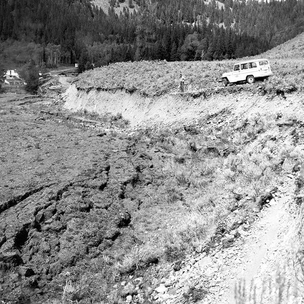
Hebgen Lake fault scarp in 1959. USGS photo by J. R. Stacy.
Hebgen Lake fault scarp in 1959. USGS photo by J. R. Stacy.