
Scenic shots of Rocky Mountain National Park, Grand Lake near the South entrance to the park.
Images
Explore photos, graphics, and illustrations related to projects from across the CASC Network. And be sure to check out our Climate Illustrations page, featuring free-to-download illustrations that help describe tricky climate concepts and explain how climate change affects the world around us.
Filter Total Items: 639

Rocky Mountain National Park
Scenic shots of Rocky Mountain National Park, Grand Lake near the South entrance to the park.

Rocky Mountain National Park
Scenic shots of Rocky Mountain National Park, near Bear Lake.
Scenic shots of Rocky Mountain National Park, near Bear Lake.
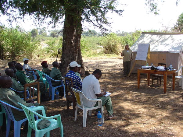
Mara Weisenberger instructing village scouts in Tanzania
Mara Weisenberger instructing village scouts in TanzaniaWorking with FWS partner, Mara Weisenberger, to instruct village scouts in monitoring and data collection methods for Tanzania’s Wildlife Management Areas Program, 2010 (DOI-ITAP). (credit - M. Eaton)
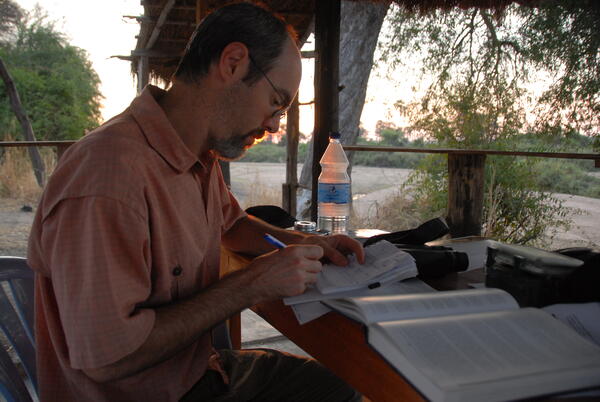
Taking notes while observing elephants in Ruaha, Tanzania
Taking notes while observing elephants in Ruaha, TanzaniaTaking notes while observing elephants at a waterhole in Ruaha, Tanzania while on a short-term mission in 2010 with DOI’s International Technical Assistance Program (ITAP) to develop methods and train scouts in wildlife monitoring for Tanzania’s village-based Wildlife Management Areas. (credit – M. Weisenberger, DOI)

Autumn Vista Along the Snake River
Autumn foliage on the Snake River.
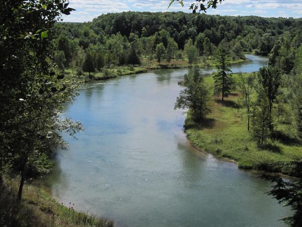
Manistee River, MI
Manistee River, MI in the Midwestern US.
Manistee River, MI in the Midwestern US.

Bluffs along the Little Missouri River
Little Missouri River at Marmarth, North Dakota, streamflow 65.5 cubic feet per second.
Little Missouri River at Marmarth, North Dakota, streamflow 65.5 cubic feet per second.

Black Skimmers
Birds found in and around the Salton Sea, California.
By

Medano Creek Wildfire
Medano Creek after wildfire.

North Dakota Sky, Water, and Prairie
View near a groundwater well in North Dakota.
View near a groundwater well in North Dakota.

Smoke From Schultz Pass Forest Fire, Flagstaff, Arizona, June 20, 2010
Smoke From Schultz Pass Forest Fire, Flagstaff, Arizona, June 20, 2010Panorama (180 degree field of view) photograph of smoke rising from the Schultz Pass fire near Flagstaff, Arizona, at 1:34 p.m. on its day of ignition, June 20, 2010. Over the following 10 days, the fire burned an estimated 15,075 acres, or more than 23 square miles of northern Arizona forest, and cost more than \$8.6 million to fight.

Hills along the Missouri River Valley
View near a groundwater well site, looking at Missouri River, near Huff, North Dakota.
View near a groundwater well site, looking at Missouri River, near Huff, North Dakota.

Hillside in the Missouri River Valley
View from a groundwater well site. Missouri River in the distance, near Huff, North Dakota.
View from a groundwater well site. Missouri River in the distance, near Huff, North Dakota.

Rufous Hummingbird in Bellingham, Washington
Rufous Hummingbird in Bellingham, Washington. Rufous Hummingbirds are present in southeast and some select southcentral locations in Alaska.
Rufous Hummingbird in Bellingham, Washington. Rufous Hummingbirds are present in southeast and some select southcentral locations in Alaska.

Mountains over Copper River, AK
Mountains towering above the mouth of the Copper River from the coastal Gulf of Alaska.
Mountains towering above the mouth of the Copper River from the coastal Gulf of Alaska.
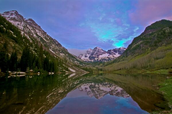
Maroon Bells at Sunrise
Maroon Bells at Sunrise.
Maroon Bells at Sunrise.

Coastal Erosion in San Francisco
Winter storm erosion of coastal bluffs at Ocean Beach, San Francisco.
Winter storm erosion of coastal bluffs at Ocean Beach, San Francisco.

Upper Colorado River near Moab, Utah
The Colorado River near Moab, Utah. The entire Colorado River Basin currently supports 50 million people, and that amount is expected to increase by 23 million between 2000 and 2030. A new USGS study shows more than half of the streamflow in the Upper Colorado River Basin originates as groundwater. Photo by M. Miller.
The Colorado River near Moab, Utah. The entire Colorado River Basin currently supports 50 million people, and that amount is expected to increase by 23 million between 2000 and 2030. A new USGS study shows more than half of the streamflow in the Upper Colorado River Basin originates as groundwater. Photo by M. Miller.

Ken Pierce providing geology lesson during field trip Jackson Hole
Ken Pierce providing geology lesson during field trip Jackson HoleKen Pierce, at the Curtis Canyon Overlook in Jackson Hole, leading the 2003 INQUA (International Union of Quaternary Research) field trip, one of his many geologic field trips about the Greater Yellowstone Geoecosystem.


Unidentified Spruce (Picea Sp.)
Unidentified spruce tree with rain dripping from it.
Unidentified spruce tree with rain dripping from it.