



Regional Super El Niño Impacts: Alaska
Explore the forecasted impacts of the 2026 El Niño in Alaska and its implications for the management of resources.
What Does El Niño Mean for Alaska?
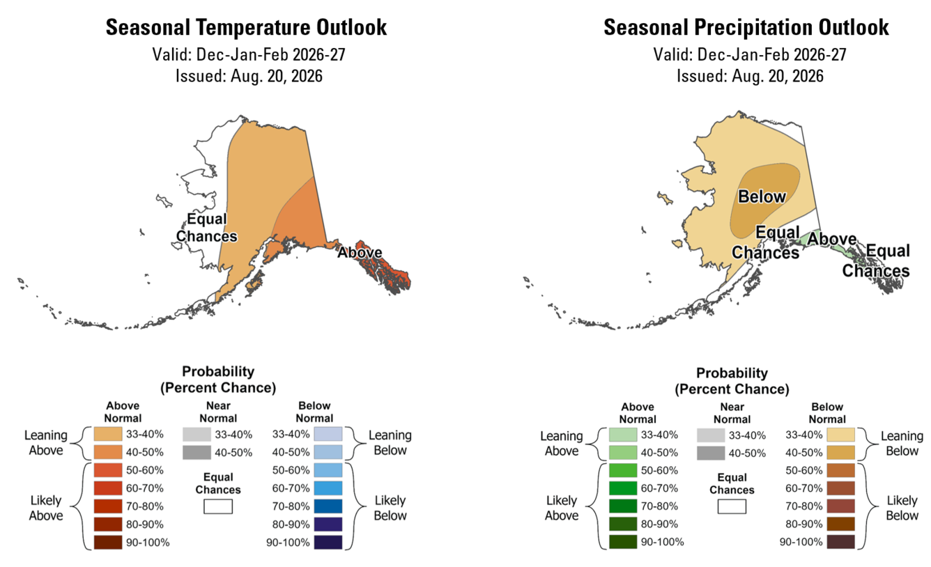
Unlike other regions, the linkage between El Niño and seasonal climate patterns is weak for most of Alaska. Alaska’s weather patterns during the autumn and winter are more closely connected to the persistence of the Aleutian Low, ocean temperatures in the North Pacific and Bering Sea, and the rate and coverage of sea ice development. These other factors can attenuate or accentuate the influence of El Niño, and they are largely not predictable many months in advance. Current and forecasted ocean temperature in the North Pacific and Bering Sea are a little warm, but not very warm, in areas of ocean that most influence the persistence of the Aleutian Low.
Temperature
During an El Niño event, odds generally increase only 5%-10% for a slightly warmer than normal winter, with the strongest signal in Southeast Alaska to no change in the odds for Northwest Alaska. In the four strongest El Niño events, three displayed generally modest differences from normal, with above- to much-above winter temperatures along Alaska’s southern and southeastern coasts. The winter of 2015–2016 was incredibly warm, the second warmest on record, statewide. However, further analysis of the weather dynamics that winter determined that El Niño was at most a modest contributor.
Precipitation
El Niño is also associated with slightly increased odds of higher-than-normal precipitation. This includes a small increase in the odds for storms in southern Alaska and a small decrease in odds for storms in Interior Alaska. Looking at past strong El Niño events demonstrates that it does not provide much predictability for Alaska. During the winters of 1982–1983 and 1997–1998, most of Alaska was slightly drier than normal, with some areas of the southern and southeastern coast receiving near or just above normal precipitation. The winter of 1991–1992 delivered above normal precipitation to eastern Alaska, including Southeast Alaska’s Panhandle and normal to dry conditions over the northern and western parts of the state. The 2015–2016 El Niño developed during a mid- and high-latitude marine heatwave sometimes referred to as “the Blob”. That winter, western and central Alaska experienced record dry conditions and parts of interior Alaska received the second and third lowest precipitation on record.
Snowfall
Snowfall has a more complex relationship with El Niño as compared to total precipitation. For Alaska, the challenge comes from the combined shift in odds toward slightly warmer and wetter conditions that potentially result in both more or less snowfall depending on localized weather dynamics for any given storm. For landscapes that historically experience temperatures closer to those needed for snow, warmer conditions can lead to less snow. For areas that have been, in the past, typically (or always) sufficiently cold and dry, such as those at higher elevations, wetter conditions can lead to more snowfall. Other factors, including Arctic dynamics, North Pacific and Bering Sea water temperatures, and sea ice formation either favor rainfall or snowfall given their interactions with the tropical influences of a Super El Niño and physiography of regional landforms. While we don’t have many Super El Niño events to use as analogs, we do know that these variable interactions play a large role and are not reliably predictable several months out.
Learn more about El Niño and snow>>
What Does This Mean for the Management of Natural Resources?
Odds are slightly increased for lower-than-normal snowfall accumulation and earlier melt in most of Alaska, but those odds aren't much higher than equal without knowledge of other factors. The fact that long-term (decadal plus) trends in seasonal temperature are warmer likely skews the odds further toward warmer, wetter, and marginally less snow accumulation and snow season duration.
Questions?
Contact the Alaska CASC if you’d like to discuss this El Niño and adaptation strategies for management of your resources.